- Bradford, New Hampshire
Infobox Settlement
official_name = Bradford, New Hampshire
nickname =
motto =
image_
imagesize =
image_caption =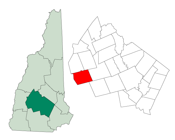
mapsize = 250px
map_caption = Location in Merrimack County,New Hampshire
settlement_type = Town
mapsize1 =
map_caption1 =
subdivision_type = Country
subdivision_name =United States
subdivision_type1 = State
subdivision_name1 =New Hampshire
subdivision_type2 = County
subdivision_name2 = Merrimack
government_type =
leader_title =Board of Selectmen
leader_name = Peter Fenton, Chairman
Andrew Pinard
Charles "Chip" Meany
established_title = Incorporated
established_date = 1787
area_magnitude = 1 E8
area_total_km2 = 93.3
area_total_sq_mi = 36.0
area_land_km2 = 91.5
area_land_sq_mi = 35.3
area_water_km2 = 1.8
area_water_sq_mi = 0.7
area_water_percent = 1.94
population_as_of = 2000
population_note =
population_total = 1454
population_density_km2 = 15.9
population_density_sq_mi = 41.2
timezone = Eastern
utc_offset = -5
timezone_DST = Eastern
utc_offset_DST = -4
latd = 43 |latm = 16 |lats = 12 |latNS = N
longd = 71 |longm = 57 |longs = 36 |longEW = W
elevation_m = 209
elevation_ft = 686
website = [http://www.bradfordnh.com/ www.bradfordnh.com]
postal_code_type =ZIP code
postal_code = 03221
area_code = 603
blank_name = FIPS code
blank_info = 33-06980
blank1_name = GNIS feature ID
blank1_info = 0873549
footnotes =Bradford is a town in Merrimack County,
New Hampshire ,United States . The population was 1,454 at the 2000 census.History
Originally granted as New Bradford in 1771, the town was later called Bradfordton, then finally Bradford upon incorporation in 1787.
Geography
According to the
United States Census Bureau , the town has a total area of convert|36.0|sqmi|km2, of which convert|35.3|sqmi|km2|abbr=on is land and convert|0.7|sqmi|km2|abbr=on is water, comprising 1.94% of the town. The village of Bradford is located near the northern border of the town, at the intersection of routes 103 and 114, just north of theWarner River and adjacent to the outlet of Todd Lake. The largest water body in the town isLake Massasecum , near the town's eastern border.The highest point in Bradford is an unnamed convert|2096|ft|m|adj=on summit overlooking Ayers Pond on the town's western border. Knights Hill—convert|1910|ft|m|abbr=on above
sea level —and Rowes Hill—convert|1950|ft|m|abbr=on—constitute a large, hilly mass occupying the southern portion of town. Bradford lies fully within theMerrimack River watershed.cite book |title=Water Use in New Hampshire: An Activities Guide for Teachers |url=http://nh.water.usgs.gov/Publications/nh.intro.html |last=Foster |first=Debra H. |coauthors=Batorfalvy, Tatianna N.; and Medalie, Laura |publisher=U.S. Department of the Interior and U.S. Geological Survey |year=1995]Demographics
As of the
census GR|2 of 2000, there were 1,454 people, 559 households, and 403 families residing in the town. Thepopulation density was 41.2 people per square mile (15.9/km²). There were 762 housing units at an average density of 21.6/sq mi (8.3/km²). The racial makeup of the town was 97.25% White, 0.28% African American, 0.34% Native American, 0.14% Asian, 0.28% from other races, and 1.72% from two or more races. Hispanic or Latino of any race were 1.10% of the population.There were 559 households out of which 34.3% had children under the age of 18 living with them, 57.6% were married couples living together, 11.3% had a female householder with no husband present, and 27.9% were non-families. 20.2% of all households were made up of individuals and 7.7% had someone living alone who was 65 years of age or older. The average household size was 2.56 and the average family size was 2.96.
In the town the population was spread out with 25.2% under the age of 18, 7.2% from 18 to 24, 27.0% from 25 to 44, 28.0% from 45 to 64, and 12.7% who were 65 years of age or older. The median age was 40 years. For every 100 females there were 99.7 males. For every 100 females age 18 and over, there were 94.1 males.
The median income for a household in the town was $49,018, and the median income for a family was $57,083. Males had a median income of $34,803 versus $25,938 for females. The
per capita income for the town was $22,240. About 2.5% of families and 4.1% of the population were below thepoverty line , including 2.2% of those under age 18 and 6.2% of those age 65 or over.References
External links
* [http://www.bradfordnh.com Town website]
* [http://www.nh.gov/nhes/elmi/htmlprofiles/bradford.html New Hampshire Economic and Labor Market Information Bureau Profile]
Wikimedia Foundation. 2010.