- Bristol, New Hampshire
Infobox Settlement
official_name = Bristol, New Hampshire
nickname =
motto =
image_
imagesize =
image_caption =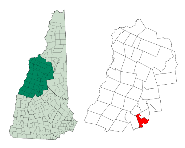
mapsize = 250px
map_caption = Location inGrafton County, New Hampshire
settlement_type = Town
mapsize1 =
map_caption1 =
subdivision_type = Country
subdivision_name =United States
subdivision_type1 = State
subdivision_name1 =New Hampshire
subdivision_type2 = County
subdivision_name2 = Grafton
government_type =
leader_title =Board of Selectmen
leader_name = Rick Alpers, Chair
Joseph Denning
Bruce VanDervan
Steve Favorite
Paul Fraser
established_title = Incorporated
established_date = 1819
area_magnitude = 1 E8
area_total_km2 = 57.7
area_total_sq_mi = 22.3
area_land_km2 = 44.9
area_land_sq_mi = 17.3
area_water_km2 = 12.7
area_water_sq_mi = 4.9
area_water_percent = 22.10
population_as_of = 2000
population_note =
population_total = 3033
population_density_km2 = 67.5
population_density_sq_mi = 174.9
timezone = Eastern
utc_offset = -5
timezone_DST = Eastern
utc_offset_DST = -4
latd = 43 |latm = 35 |lats = 28 |latNS = N
longd = 71 |longm = 44 |longs = 12 |longEW = W
elevation_m = 142
elevation_ft = 466
website = [http://www.townofbristolnh.org www.townofbristolnh.org]
postal_code_type =ZIP code
postal_code = 03222
area_code = 603
blank_name = FIPS code
blank_info = 33-07700
blank1_name = GNIS feature ID
blank1_info = 0873552
footnotes =Bristol is a town in Grafton County,
New Hampshire ,United States . The population was 3,033 at the 2000 census. It is home toWellington State Park andSugar Hill State Forest . Surrounded by hills and lakes, Bristol includes the lower two-thirds ofNewfound Lake , a resort area. The primary settlement in town, where over 55% of the population resides, is defined by the U.S. Census Bureau as the Bristolcensus-designated place (CDP) and is located at the intersection of New Hampshire Routes 3A and 104.History
The town was incorporated in 1819. Extensive deposits of fine
sand orclay similar to the "Bristol sand" used inBristol ,England to makefine china andpottery gave the town its name. Here the sand was used to make a superior qualitybrick , marketed as "Bristol brick." Withwater power from thePemigewasset River , the town was a center of manufacturing in the early days for goods such aspaper ,leather ,woolen s,flannel , bedsteads and piano stools.Bristol is one of four towns with shoreline on Newfound Lake, which has been a tourist destination since the mid-1800s. Farmers at first rented rooms and provided meals, but in the 1870s, hotels including the Hotel Bristol and G.G. Brown Hotel were built. In the 1920s, W.F. Darling created a compound of about 100 cottages for rent, first known as "Hiland Park" and later as "Bungalo Village". In 2005, the compound was sold to a proprietor who sold individual cottages to permanent owners.
Notable inhabitants
*
John Cheever , writer (summer resident)
*Thomas A. Watson , inventor (summer resident) Fact|date=July 2007Geography
According to the
United States Census Bureau , the town has a total area of convert|22.3|sqmi|km2, of which convert|17.3|sqmi|km2 is land and convert|4.99|sqmi|km2 is water, comprising 22.10% of the town. Bristol is drained by thePemigewasset River (forming the southeastern boundary of the town), the Smith River (on the town's short southern boundary) and the Newfound River, draining Newfound Lake and most of the center of town. The highest point in town is Bristol Peak, elevation convert|1803|ft|m abovesea level . Bristol lies fully within theMerrimack River watershed.cite book |title=Water Use in New Hampshire: An Activities Guide for Teachers |url=http://nh.water.usgs.gov/Publications/nh.intro.html |last=Foster |first=Debra H. |coauthors=Batorfalvy, Tatianna N.; and Medalie, Laura |publisher=U.S. Department of the Interior and U.S. Geological Survey |year=1995]The town center, defined as a
census-designated place (CDP), covers an area of convert|4.8|sqmi|km2, about 21.5% of the area of the town.Demographics
As of the
census of 2000, there were 3,033 people, 1,219 households, and 830 families residing in the town. Thepopulation density was 174.9 people per square mile (67.5/km²). There were 2,073 housing units at an average density of 46.2 persons/km² (119.5 persons/sq mi). The racial makeup of the town was 96.08% White, 0.26%African American , 0.40% Native American, 1.38%Asia n, 0.03% Pacific Islander, 0.49% from other races, and 1.35% from two or more races. 0.96% of the population wereHispanic orLatino of any race.There were 1,219 households out of which 31.3% had children under the age of 18 living with them, 53.3% were married couples living together, 11.0% have a woman whose husband does not live with her, and 31.9% were non-families. 24.8% of all households were made up of individuals and 9.1% had someone living alone who was 65 years of age or older. The average household size was 2.47 and the average family size was 2.94.
In the town the population was spread out with 24.3% under the age of 18, 7.0% from 18 to 24, 29.9% from 25 to 44, 24.6% from 45 to 64, and 14.2% who were 65 years of age or older. The median age was 38 years. For every 100 females there were 97.3 males. For every 100 females age 18 and over, there were 91.5 males.
The median income for a household in the town was $38,032, and the median income for a family was $44,766. Males had a median income of $31,088 versus $22,406 for females. The
per capita income for the town was $19,807. 6.9% of the population and 5.5% of families were below the poverty line. Out of the total people living in poverty, 7.6% are under the age of 18 and 8.4% are 65 or older.Town center
As of the
census of 2000, there were 1,670 people, 692 households, and 458 families residing in the CDP (census-designated place ) occupying the town center. Thepopulation density was 352.1 people per square mile (136.0/km²). There were 928 housing units at an average density of 75.6 persons/km² (195.7 persons/sq mi). The racial makeup of the town was 96.53% White, 0.06%African American , 0.42% Native American, 1.20%Asia n, 0.00% Pacific Islander, 0.06% from other races, and 1.74% from two or more races. 1.14% of the population wereHispanic orLatino of any race.There were 692 households out of which 31.9% had children under the age of 18 living with them, 48.1% were married couples living together, 14.2% have a woman whose husband does not live with her, and 33.8% were non-families. 28.3% of all households were made up of individuals and 12.0% had someone living alone who was 65 years of age or older. The average household size was 2.39 and the average family size was 2.90.
In the CDP the population was spread out with 24.8% under the age of 18, 8.3% from 18 to 24, 29.2% from 25 to 44, 22.8% from 45 to 64, and 15.0% who were 65 years of age or older. The median age was 38 years. For every 100 females there were 94.9 males. For every 100 females age 18 and over, there were 88.0 males.
The median income for a household is $32,992, and the median income for a family was $40,804. Males had a median income of $30,478 versus $21,741 for females. The
per capita income for the town was $20,011. 9.8% of the population and 7.7% of families were below the poverty line. Out of the total people living in poverty, 10.6% are under the age of 18 and 14.0% are 65 or older.References
External links
* [http://www.townofbristolnh.org Town website]
* [http://www.nhstateparks.org/state-parks/alphabetical-order/wellington-state-park/ Wellington State Park]
* [http://www.nh.gov/nhes/elmi/htmlprofiles/bristol.html New Hampshire Economic and Labor Market Information Bureau Profile]
Wikimedia Foundation. 2010.