- Plaistow, New Hampshire
Infobox Settlement
official_name = Plaistow, New Hampshire
nickname =
motto =
image_
imagesize =
image_caption =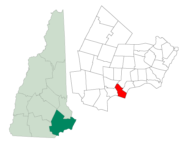
mapsize = 250px
map_caption = Location in Rockingham County,New Hampshire
settlement_type = Town
mapsize1 =
map_caption1 =
subdivision_type = Country
subdivision_name =United States
subdivision_type1 = State
subdivision_name1 =New Hampshire
subdivision_type2 = County
subdivision_name2 = Rockingham
government_type =
leader_title =Board of Selectmen
leader_name = John A. Sherman, Chair
Lawrence W. Gil
Charles L. Blinn, Jr.
Robert J. Gray
Daniel J. Poliquin
established_title = Incorporated
established_date = 1746
area_magnitude = 1 E8
area_total_km2 = 27.6
area_total_sq_mi = 10.6
area_land_km2 = 27.5
area_land_sq_mi = 10.5
area_water_km2 = 0.1
area_water_sq_mi = 0.1
area_water_percent = 0.09
population_as_of = 2007
population_note =
population_total = 7,657
population_density_km2 = 278.4
population_density_sq_mi = 729.3
timezone = Eastern
utc_offset = -5
timezone_DST = Eastern
utc_offset_DST = -4
latd = 42 |latm = 50 |lats = 11 |latNS = N
longd = 71 |longm = 05 |longs = 41 |longEW = W
elevation_m = 31
elevation_ft = 102
website = [http://www.plaistow.com/ www.plaistow.com]
postal_code_type =ZIP code
postal_code = 03865
area_code = 603
blank_name = FIPS code
blank_info = 33-62500
blank1_name = GNIS feature ID
blank1_info = 0873701
footnotes =Plaistow is a town in Rockingham County,
New Hampshire ,United States . The population was 7,747 at the 2000 census. The name of the town is pronounced as "Plass-tow" (IPAEng|plæstaʊ, where "tow" rhymes with "now") or as "Plass-toe" (IPAEng|plæstoʊ).History
According to the Plaistow website, the town was officially established in 1746 after a boundary dispute between the
Massachusetts Bay Colony and theNew Hampshire Grants . It is the only town outside theUnited Kingdom with the name Plaistow. In 1776 the western part of Plaistow became its own town, Atkinson.The presenttown hall was built in 1895. Each year, the town celebrates 'Old Home Day', with a parade, fireworks, and carnival-type atmosphere on the Town Hall Lawn to celebrate the town's anniversary.Geography
According to the
United States Census Bureau , the town has a total area of convert|10.6|sqmi|km2, of which 0.09% is water. The highest point in Plaistow is an unnamed summit at convert|384|ft|m abovesea level near the town's northern end.Demographics
As of the
census GR|2 of 2000, there were 7,747 people, 2,871 households, and 2,150 families residing in the town. Thepopulation density was 728.8 people per square mile (281.4/km²). There were 2,927 housing units at an average density of 275.4/sq mi (106.3/km²). The racial makeup of the town was 98.33% White, 0.21% African American, 0.10% Native American, 0.50% Asian, 0.30% from other races, and 0.56% from two or more races. Hispanic or Latino of any race were 1.32% of the population.There were 2,871 households out of which 35.6% had children under the age of 18 living with them, 60.1% were married couples living together, 10.7% had a female householder with no husband present, and 25.1% were non-families. 19.1% of all households were made up of individuals and 6.0% had someone living alone who was 65 years of age or older. The average household size was 2.69 and the average family size was 3.10.
In the town the population was spread out with 25.8% under the age of 18, 7.0% from 18 to 24, 32.0% from 25 to 44, 25.0% from 45 to 64, and 10.1% who were 65 years of age or older. The median age was 37 years. For every 100 females there were 95.7 males. For every 100 females age 18 and over, there were 94.9 males.
The median income for a household in the town was $61,707, and the median income for a family was $66,852. Males had a median income of $45,756 versus $31,657 for females. The
per capita income for the town was $25,255. About 2.1% of families and 3.2% of the population were below thepoverty line , including 1.4% of those under age 18 and 7.5% of those age 65 or over.Education
Plaistow is home to
Timberlane Regional High School (grades 9-12) andTimberlane Regional Middle School (grades 6-8), which serve as middle and high school for the towns of Plaistow, Atkinson, Danville and Sandown. Plaistow is also home toPollard Elementary School , which services only Plaistow children grades 1-5. The school has had noticeable success in both music and wrestling as well as field hockey.Economy and transportation
Plaistow's economy is centered along
New Hampshire Route 125 , a north-south road that connects the town with Haverhill,Massachusetts to the south and Kingston, Epping, and Rochester to the north. Local businesses and numerous large chain stores are located along Route 125, which has become known for problems with heavy traffic during weekday commuting and weekend shopping hours.Route 125 intersects with Interstate 495 in Massachusetts two miles south of Plaistow. Commuters to Massachusetts are able to use a New Hampshire
park and ride facility located on Westville Road, just east of Route 125. The main railroad line from Boston to Portland,Maine , utilized byAmtrak and by freight trains, passes through Plaistow. Passenger stations for the AmtrakDowneaster are available in Haverhill to the south and Exeter to the north.Neighboring towns and cities
Geographic Location (8-way)
Centre =
References
External links
* [http://www.plaistow.com Town website]
* [http://www.plaistowlibrary.com/ Plaistow Library web site]
* [http://www.plaistowhistorical.org/ Plaistow Historical Society web site]
* [http://www.nh.gov/nhes/elmi/htmlprofiles/plaistow.html New Hampshire Economic and Labor Market Information Bureau Profile]
* [http://www.pollardschool.com/ Pollard Elementary School]
* [http://www.timberlanems.com/ Timberlane Regional Middle School]
* [http://www.timberlanehs.com/ Timberlane Regional High School]

Wikimedia Foundation. 2010.