- Pembroke, New Hampshire
Infobox Settlement
official_name = Pembroke, New Hampshire
nickname =
motto =
image_
imagesize =
image_caption =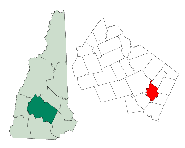
mapsize = 250px
map_caption = Location in Merrimack County,New Hampshire
settlement_type = Town
mapsize1 =
map_caption1 =
subdivision_type = Country
subdivision_name =United States
subdivision_type1 = State
subdivision_name1 =New Hampshire
subdivision_type2 = County
subdivision_name2 = Merrimack
government_type =
leader_title =Board of Selectmen
leader_name = Brian B. Tufts
Larry W. Young, Sr.
Daniel D. Crean
Larry J. Preston
Fred Kline
established_title = Incorporated
established_date = 1759
area_magnitude = 1 E8
area_total_km2 = 59.5
area_total_sq_mi = 23.0
area_land_km2 = 59.1
area_land_sq_mi = 22.8
area_water_km2 = 0.4
area_water_sq_mi = 0.2
area_water_percent = 0.70
population_as_of = 2000
population_note =
population_total = 6897
population_density_km2 = 116.6
population_density_sq_mi = 302.1
timezone = Eastern
utc_offset = -5
timezone_DST = Eastern
utc_offset_DST = -4
latd = 43 |latm = 08 |lats = 48 |latNS = N
longd = 71 |longm = 27 |longs = 27 |longEW = W
elevation_m = 126
elevation_ft = 413
website = [http://www.pembroke-nh.com/ www.pembroke-nh.com]
postal_code_type =ZIP code
postal_code = 03275
area_code = 603
blank_name = FIPS code
blank_info = 33-60020
blank1_name = GNIS feature ID
blank1_info = 0873696
footnotes =Pembroke is a town in Merrimack County,
New Hampshire ,United States . The population was 6,897 at the 2000 census. Pembroke includes part of the village of Suncook. Thecenter of population of New Hampshire is located in Pembroke. [cite web| url=http://www.census.gov/geo/www/cenpop/statecenters.txt| title="Population and Population Centers by State: 2000"| publisher=U.S. Census Bureau| accessdate=2008-05-06]History
First granted in 1728, the town was known as "Lovewell's Town", in honor of Captain John Lovewell, who built the
stockade at Ossipee. Shortly afterward, the town took the name of "Suncook", thePennacook Abenaki name for the river flowing through the area. When the town was incorporated in 1759 by Colonial GovernorBenning Wentworth , it was given the name "Pembroke" in honor of Henry Herbert, ninthEarl of Pembroke in southernWales .Pembroke's early history is reflected in the various mills of the downtown area, located to use
water power from theSuncook River . The better-known mills were the Pembroke Mills, Webster Manufacturing and China Manufacturing, all producing print cloth. Pembroke industries includedbrickmaking , with bricks manufactured fromclay along theMerrimack River . In 1852, the Portsmouth to ConcordRailroad established a station in Pembroke.Education
There are currently four public schools in Pembroke. The Village School is located in the village of Suncook and houses kindergarten and first grade. The Hill School is attended by children in the second, third, and fourth grades. Three Rivers School, named after the three rivers that form most of the borders of the town, was built in the early 1990s and contains fifth through eighth grade.The town's high school is Pembroke Academy, founded in 1818 as a private school. The school today is public and takes students from Pembroke and from the neighboring towns of Allenstown, Epsom, Chichester, and historically, Deerfield. With approximately 1,000 students, the school is Class I in athletics, the second highest class, and the mascot of the school is the Spartan.
Notable inhabitants
*
Megan McTavish (b. 1949), Daytime Emmy winner and soap opera writer ("All My Children ", "Guiding Light ", "One Life to Live ", "General Hospital ")
*Plausawa (c.1700-1754), Native American who lived on Plausawa Hill. Both the hill and the golf course are named after him.
*Caleb Stark (1759 - 1838), Revolutionary War officer and son of Gen.John Stark
*Laurence F. Whittemore (1894 - 1960), president of theFederal Reserve Bank of Boston (1946-1948)Geography
According to the
United States Census Bureau , the town has a total area of convert|23.0|sqmi|km2|1, of which convert|22.8|sqmi|km2|abbr=on|1 is land and convert|0.2|sqmi|km2|abbr=on|1 is water, comprising 0.70% of the town. Pembroke is drained by the Suncook, Soucook and Merrimack rivers. The highest point in town, Plausawa Hill, elevation convert|1000|ft|m|sigfig=3 abovesea level , is in the north.Demographics
As of the
census GR|2 of 2000, there were 6,897 people, 2,661 households, and 1,876 families residing in the town. Thepopulation density was 302.1 people per square mile (116.6/km²). There were 2,734 housing units at an average density of 119.8/sq mi (46.2/km²). The racial makeup of the town was 97.84% White, 0.38% African American, 0.26% Native American, 0.38% Asian, 0.03% from other races, and 1.12% from two or more races. Hispanic or Latino of any race were 0.43% of the population.There were 2,661 households out of which 37.3% had children under the age of 18 living with them, 55.7% were married couples living together, 10.4% had a female householder with no husband present, and 29.5% were non-families. 23.0% of all households were made up of individuals and 7.3% had someone living alone who was 65 years of age or older. The average household size was 2.59 and the average family size was 3.06.
In the town the population was spread out with 26.9% under the age of 18, 6.9% from 18 to 24, 33.1% from 25 to 44, 23.1% from 45 to 64, and 9.9% who were 65 years of age or older. The median age was 37 years. For every 100 females there were 98.3 males. For every 100 females age 18 and over, there were 94.5 males.
The median income for a household in the town was $49,494, and the median income for a family was $57,106. Males had a median income of $37,786 versus $26,781 for females. The
per capita income for the town was $20,800. About 3.0% of families and 5.4% of the population were below thepoverty line , including 3.2% of those under age 18 and 10.9% of those age 65 or over.References
External links
* [http://www.pembroke-nh.com Town website]
* [http://www.nh.gov/nhes/elmi/htmlprofiles/pembroke.html New Hampshire Economic and Labor Market Information Bureau Profile]
* [http://www.sau53.org/ School District Website]
Wikimedia Foundation. 2010.