- Sutton, New Hampshire
-
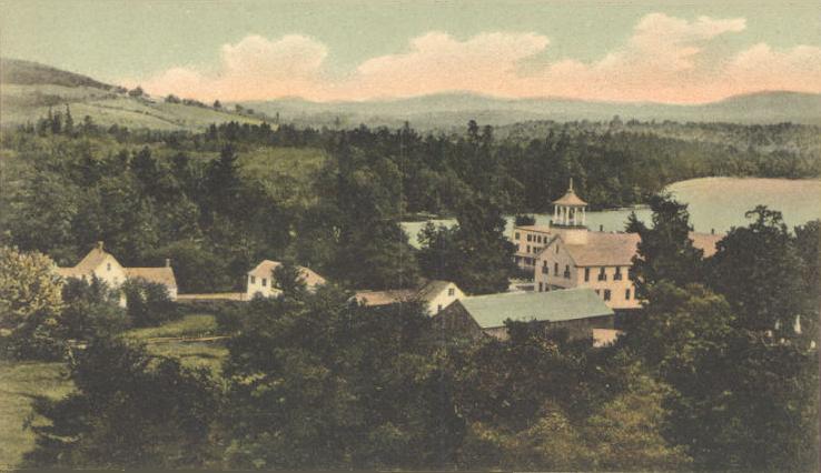
Sutton, New Hampshire — Town — View of North Sutton c. 1905 Location within the state of New Hampshire
 Sutton, New Hampshire
Coordinates: 43°20′38″N 71°56′28″W / 43.34389°N 71.94111°W Country United States State New Hampshire County Merrimack Incorporated 1784 Government – Board of selectmen Robert Wright Jr., Chair
Walter Baker, Jr.
Richard GoddardArea – Total 43.1 sq mi (111.7 km2) – Land 42.3 sq mi (109.7 km2) – Water 0.8 sq mi (2.1 km2) Elevation 928 ft (283 m) Population (2010) – Total 1,837 – Density 42.6/sq mi (16.5/km2) Time zone Eastern (EST) (UTC-5) – Summer (DST) EDT (UTC-4) Area code(s) 603 FIPS code 33-75460 GNIS feature ID 0873734 Website http://www.sutton-nh.gov/ Sutton is a town in Merrimack County, New Hampshire, United States. The population was 1,837 at the 2010 census.[1] Sutton is home to Wadleigh State Beach on Kezar Lake.
Contents
History
The town was granted in 1749 by the Masonian Proprietors to inhabitants of Haverhill, Newbury and Bradford, Massachusetts, as well as Kingston, New Hampshire. It was called Perrystown after Obadiah Perry, one of the proprietors. But the French and Indian War delayed settlement until 1767, when David Peaslee arrived. Many proprietors forfeited their claims, even with an extension in 1773, so the town was regranted in 1784. The second group of settlers were from Sutton, Massachusetts, source of the town's current name.[2]
Geography
According to the United States Census Bureau, the town has a total area of 43.1 square miles (111.6 km2), of which 42.3 sq mi (109.6 km2) is land and 0.8 sq mi (2.1 km2) (1.85%) is water. The highest point in Sutton is the summit of Kings Hill, at approximately 1,930 feet (590 m) above sea level, in the northwest corner of the town.
The town is drained primarily by tributaries of the Warner River, which flows to the Contoocook River and ultimately the Merrimack River. The Lane River, a tributary of the Warner, drains a large portion of the center of town. The northern portion of town is drained by tributaries of the Blackwater River, another tributary of the Contoocook. The extreme northwest corner of town is part of the Lake Sunapee watershed, draining via the Sugar River of western New Hampshire into the Connecticut River.
Sutton is served by Interstate 89 and New Hampshire Route 114.
Demographics
As of the census[3] of 2000, there were 1,544 people, 621 households, and 457 families residing in the town. The population density was 36.5 people per square mile (14.1/km²). There were 826 housing units at an average density of 19.5 per square mile (7.5/km²). The racial makeup of the town was 97.54% White, 0.06% African American, 0.32% Native American, 0.45% Asian, 0.06% Pacific Islander, 0.39% from other races, and 1.17% from two or more races. Hispanic or Latino of any race were 0.97% of the population.
There were 621 households out of which 30.0% had children under the age of 18 living with them, 65.1% were married couples living together, 6.0% had a female householder with no husband present, and 26.4% were non-families. 20.9% of all households were made up of individuals and 7.6% had someone living alone who was 65 years of age or older. The average household size was 2.47 and the average family size was 2.88.
In the town the population was spread out with 22.2% under the age of 18, 5.2% from 18 to 24, 26.5% from 25 to 44, 30.4% from 45 to 64, and 15.8% who were 65 years of age or older. The median age was 43 years. For every 100 females there were 94.9 males. For every 100 females age 18 and over, there were 92.9 males.
The median income for a household in the town was $50,924, and the median income for a family was $56,685. Males had a median income of $34,250 versus $30,658 for females. The per capita income for the town was $24,432. About 2.8% of families and 5.0% of the population were below the poverty line, including 8.0% of those under age 18 and 4.7% of those age 65 or over.
Notable residents
- John Eaton, general and commissioner of education
- Jonathan Harvey, congressman
- Matthew Harvey, congressman and governor of New Hampshire
- John S. Pillsbury, businessman and governor of Minnesota
References
- ^ United States Census Bureau, American FactFinder, 2010 Census figures. Retrieved March 23, 2011.
- ^ Coolidge, Austin J.; John B. Mansfield (1859). A History and Description of New England. Boston, Massachusetts. p. 661. http://books.google.com/books?id=OcoMAAAAYAAJ&lpg=PA9&dq=coolidge%20mansfield%20history%20description%20new%20england%201859&pg=PA661#v=onepage&q=&f=false.
- ^ "American FactFinder". United States Census Bureau. http://factfinder.census.gov. Retrieved 2008-01-31.
External links
- Official web site
- Sutton Free Library
- Wadleigh State Beach
- Sutton RidgeRunners Snowmobile Club
- New Hampshire Economic and Labor Market Information Bureau Profile
- Sunapee-Ragged-Kearsarge Greenway Coalition
Municipalities and communities of Merrimack County, New Hampshire Cities 
Towns Allenstown | Andover | Boscawen | Bow | Bradford | Canterbury | Chichester | Danbury | Dunbarton | Epsom | Henniker | Hill | Hooksett | Hopkinton | Loudon | New London | Newbury | Northfield | Pembroke | Pittsfield | Salisbury | Sutton | Warner | Webster | Wilmot
Villages Blodgett Landing | Contoocook | East Andover | Elkins | Penacook | South Hooksett | Suncook | Tilton-Northfield‡
Footnotes ‡This populated place also has portions in an adjacent county or counties
Coordinates: 43°20′03″N 71°57′05″W / 43.33417°N 71.95139°W
Categories:- Towns in Merrimack County, New Hampshire


Wikimedia Foundation. 2010.