- Warner, New Hampshire
Infobox Settlement
official_name = Warner, New Hampshire
nickname =
motto =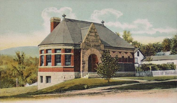
image_
imagesize =
image_caption = Pillsbury Free Library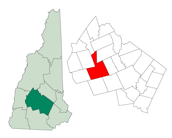
mapsize = 250px
map_caption = Location in Merrimack County,New Hampshire
settlement_type = Town
mapsize1 =
map_caption1 =
subdivision_type = Country
subdivision_name =United States
subdivision_type1 = State
subdivision_name1 =New Hampshire
subdivision_type2 = County
subdivision_name2 = Merrimack
government_type =
leader_title =Board of Selectmen
leader_name = David Hartman, Chairman
Wayne Eigabroadt
Richard Cook
established_title = Incorporated
established_date = 1774
area_magnitude = 1 E8
area_total_km2 = 144.8
area_total_sq_mi = 55.9
area_land_km2 = 144.1
area_land_sq_mi = 55.7
area_water_km2 = 0.6
area_water_sq_mi = 0.2
area_water_percent = 0.43
population_as_of = 2000
population_note =
population_total = 2760
population_density_km2 = 19.1
population_density_sq_mi = 49.6
timezone = Eastern
utc_offset = -5
timezone_DST = Eastern
utc_offset_DST = -4
latd = 43 |latm = 16 |lats = 49 |latNS = N
longd = 71 |longm = 48 |longs = 57 |longEW = W
elevation_m = 136
elevation_ft = 446
website = [http://www.warner.nh.us/ warner.nh.us]
postal_code_type =ZIP code
postal_code = 03278
area_code = 603
blank_name = FIPS code
blank_info = 33-78580
blank1_name = GNIS feature ID
blank1_info = 0873745
footnotes =Warner is a town in Merrimack County,
New Hampshire ,United States . The population was 2,760 at the 2000 census. Warner includes the settlements of Davisville and Waterloo. The town is home to Magdalen College,Rollins State Park and Mount Kearsarge State Forest.History
The town was granted in 1735 as Number One by Colonial Governor
Jonathan Belcher to petitioners largely fromAmesbury, Massachusetts . Called New Amesbury, it was part of a line of settlements running between the Merrimack and Connecticut rivers intended to help defend Massachusetts againstNew France 's predations. It was regranted by the Masonian Proprietors in 1749, when it was settled with four houses and asawmill . Called Jennesstown, it was abandoned and destroyed during theFrench and Indian War . The town was granted again in 1767 to Jonathan Barnard and others, who called it Amesbury. But onSeptember 3 ,1774 , it was incorporated as Warner, named after Jonathan Warner, a leading Portsmouth citizen, namesake of the Warner House and relative of Governor John Wentworth. It was one of the last towns established under English provincial rule prior to the Revolution.Warner developed into a prosperous
farming community which producedmeat s,dairy goods,vegetable s,hay andapple s. TheWarner River and its tributaries providedwater power for mills, which in 1832 included 12sawmill s, 6gristmill s, apaper mill and 2clothing factories. By 1858, there was also acabinet manufacturer andbottle manufacturer. In 1885, industries included abedstead factory,chain factory,woolen cloth factory,iron foundry , tannery andglove manufacturer. OnSeptember 9 ,1821 , the town was hit by what is known as the Norfolk and Long Island Hurricane. It leveled houses and forests in a 16 to 18 mile (27 to 30 km) long swath of destruction beginning west ofLake Sunapee , through New London and Sutton, over the southwest spur of Mount Kearsarge and ending at the Webster line. The storm killed 4 people in Warner, seriously injured others and destroyed considerable property.Each October, on
Columbus Day weekend, Warner hosts the annual Fall Foliage Festival, attracting thousands of people from all overNew England and beyond.Notable inhabitants
*
William C. Dowling , scholar, author, social critic
* David Elliott, children's author
* Walter Harriman, governor
*Maxine Kumin , poetess
*Nehemiah G. Ordway , politician
*Charles Alfred Pillsbury , industrialist
*John Sargent Pillsbury , businessman and politicianGeography
According to the
United States Census Bureau , the town has a total area of convert|55.9|sqmi|km2|lk=on|1, of which convert|55.7|sqmi|km2|abbr=on|1 is land and convert|0.2|sqmi|km2|abbr=on|1 is water, comprising 0.43% of the town. Warner is drained by the Lane and Warner rivers. Twocovered bridges span the Warner River: the Dalton Bridge and the Waterloo Bridge.Mount Kearsarge, elevation convert|2937|ft|m|lk=on above
sea level , located in the extreme north of the town, is the highest point in Warner. Two state parks are located on the mountain:Rollins State Park in Warner and Winslow State Park in Wilmot. Mount Kearsarge is a popular hiking destination, due both to its bare, rocky summit, and to the fact that a paved road climbs from Rollins State Park to within a half mile of the summit. The peak is the highest point along the convert|75|mi|km|adj=on Sunapee-Ragged-Kearsarge Greenway, a hiking trail which links 10 towns and encircles theLake Sunapee region of western New Hampshire.The town is crossed by
Interstate 89 andNew Hampshire Route 103 . State routes 114 and 127 cross the extreme southwestern and southeastern corners of the town, respectively. Warner borders the towns of Wilmot, Andover and Salisbury to the north, Webster to the east, Hopkinton and Henniker to the south, Bradford to the west, and Sutton to the northwest.Demographics
As of the
census GR|2 of 2000, there were 2,760 people, 1,048 households, and 728 families residing in the town. Thepopulation density was 49.6 people per square mile (19.1/km²). There were 1,228 housing units at an average density of 22.1/sq mi (8.5/km²). The racial makeup of the town was 98.33% White, 0.04% African American, 0.25% Native American, 0.22% Asian, 0.11% from other races, and 1.05% from two or more races. Hispanic or Latino of any race were 0.72% of the population.There were 1,048 households out of which 33.2% had children under the age of 18 living with them, 56.6% were married couples living together, 8.9% had a female householder with no husband present, and 30.5% were non-families. 25.1% of all households were made up of individuals and 8.2% had someone living alone who was 65 years of age or older. The average household size was 2.51 and the average family size was 3.01.
In the town the population was spread out with 24.5% under the age of 18, 7.9% from 18 to 24, 28.9% from 25 to 44, 26.5% from 45 to 64, and 12.2% who were 65 years of age or older. The median age was 40 years. For every 100 females there were 98.7 males. For every 100 females age 18 and over, there were 92.0 males.
The median income for a household in the town was $44,142, and the median income for a family was $50,926. Males had a median income of $36,143 versus $25,848 for females. The
per capita income for the town was $21,588. About 5.0% of families and 6.8% of the population were below thepoverty line , including 11.0% of those under age 18 and 4.2% of those age 65 or over.ites of interest
* [http://www.indianmuseum.org/ Mount Kearsarge Indian Museum]
* [http://www.nhstateparks.org/state-parks/alphabetical-order/rollins-state-park Rollins State Park]
* [http://www.wfff.org/ Warner Fall Foliage Festival]
* [http://www.warnerhistorical.org/ Warner Historical Society & Museum]References
* [http://www.warner.nh.us/historical_sketches.htm Historical Sketches of the Town of Warner, New Hampshire (1832)]
* A. J. Coolidge & J. B. Mansfield, "A History and Description of New England", 1859; H. O. Houghton & Company, printers; Cambridge, MassachusettsExternal links
* [http://www.warner.nh.us Town of Warner, New Hampshire]
* [http://www.warner.lib.nh.us/ Pillsbury Free Library]
* [http://www.magdalen.edu/ Magdalen College]
* [http://www.nh.gov/nhes/elmi/htmlprofiles/warner.html New Hampshire Economic and Labor Market Information Bureau Profile]
Wikimedia Foundation. 2010.