- Groton, New Hampshire
-
Groton, New Hampshire — Town — Location in Grafton County, New Hampshire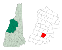
Coordinates: 43°42′06″N 71°50′08″W / 43.70167°N 71.83556°WCoordinates: 43°42′06″N 71°50′08″W / 43.70167°N 71.83556°W Country United States State New Hampshire County Grafton Incorporated 1796 Government – Board of Selectmen Miles Sinclair
Kyle Andrews
Christina McClayArea – Total 40.8 sq mi (105.7 km2) – Land 40.8 sq mi (105.6 km2) – Water 0.1 sq mi (0.1 km2) 0.12% Elevation 636 ft (194 m) Population (2010) – Total 593 – Density 14.5/sq mi (5.6/km2) Time zone Eastern (UTC-5) – Summer (DST) Eastern (UTC-4) Area code(s) 603 FIPS code 33-32180 GNIS feature ID 0873614 Website www.town-of-groton.com Groton is a town in Grafton County, New Hampshire, United States. The population was 593 at the 2010 census.[1]
Contents
History
The town was originally named Cockermouth in honor of Charles Wyndham, Baron Cockermouth and Earl of Egremont, who was Secretary of State for the Southern Department from 1761 to 1763. Due to non-settlement the land was regranted in 1776, and one of the later grantees, Samuel Blood, succeeded in renaming the town Groton after his hometown, Groton, Massachusetts, in 1792.
Geography
According to the United States Census Bureau, the town has a total area of 40.8 square miles (106 km2), of which approximately 40.8 sq mi (106 km2) is land and 0.1 sq mi (0.26 km2) is water, comprising 0.12% of the town. The highest point in Groton is the summit of Tenney Mountain, at 2,350 feet (720 m) above sea level. The Cockermouth River flows from west to east across the center of the town. Groton lies fully within the Merrimack River watershed.[2]
Demographics
As of the census[3] of 2000, there were 456 people, 175 households, and 127 families residing in the town. The population density was 11.2 people per square mile (4.3/km²). There were 342 housing units at an average density of 8.4 per square mile (3.2/km²). The racial makeup of the town was 97.81% White, 0.22% Native American, 0.88% Asian, and 1.10% from two or more races.
There were 175 households out of which 30.3% had children under the age of 18 living with them, 65.1% were married couples living together, 2.9% had a female householder with no husband present, and 27.4% were non-families. 21.1% of all households were made up of individuals and 5.7% had someone living alone who was 65 years of age or older. The average household size was 2.61 and the average family size was 2.98.
In the town the population was spread out with 25.9% under the age of 18, 6.6% from 18 to 24, 29.8% from 25 to 44, 26.3% from 45 to 64, and 11.4% who were 65 years of age or older. The median age was 40 years. For every 100 females there were 117.1 males. For every 100 females age 18 and over, there were 113.9 males.
The median income for a household in the town was $37,083, and the median income for a family was $46,250. Males had a median income of $28,906 versus $25,417 for females. The per capita income for the town was $18,680. About 6.7% of families and 6.7% of the population were below the poverty line, including 3.9% of those under age 18 and 22.0% of those age 65 or over.
References
- ^ United States Census Bureau, American FactFinder, 2010 Census figures. Retrieved March 23, 2011.
- ^ Foster, Debra H.; Batorfalvy, Tatianna N.; and Medalie, Laura (1995). Water Use in New Hampshire: An Activities Guide for Teachers. U.S. Department of the Interior and U.S. Geological Survey. http://nh.water.usgs.gov/Publications/nh.intro.html.
- ^ "American FactFinder". United States Census Bureau. http://factfinder.census.gov. Retrieved 2008-01-31.
External links
Municipalities and communities of Grafton County, New Hampshire City 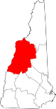
Towns Alexandria | Ashland | Bath | Benton | Bethlehem | Bridgewater | Bristol | Campton | Canaan | Dorchester | Easton | Ellsworth | Enfield | Franconia | Grafton | Groton | Hanover | Haverhill | Hebron | Holderness | Landaff | Lincoln | Lisbon | Littleton | Lyman | Lyme | Monroe | Orange | Orford | Piermont | Plymouth | Rumney | Sugar Hill | Thornton | Warren | Waterville Valley | Wentworth | Woodstock
Township Villages East Hebron | Enfield Center | Etna | Glencliff | Lyme Center | Montcalm | Mountain Lakes | North Woodstock | Pike | West Lebanon | Woodsville
Categories:- Towns in Grafton County, New Hampshire


Wikimedia Foundation. 2010.