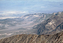
- Dante's View
-
Dante's View is a viewpoint terrace at 5,475 feet (1,669 meters) height, on the north side of Coffin Peak, along the crest of the Black Mountains, overlooking Death Valley. Dante's View is about 15 miles (25 kilometers) south of Furnace Creek in Death Valley National Park.
Contents
Viewpoint
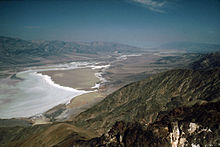
From the Dante's View parking lot, visitors can take several paths, one of which leads to the very brink of the edge, offering a dramatic panoramic view. Another path leads north 350 yards (320 m) to a rest area with picnic tables. The best time to visit Dante's View is in the cooler morning hours, when the sun is in the east. Dante's View is an excellent venue for night time star viewing with telescopes.
General
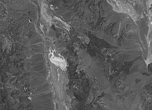
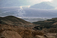
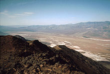
Dante's View provides a panoramic view of the southern Death Valley basin. To the south, the Owlshead Mountains, 19 miles (30 kilometers) away can be seen, and to the north, the Funeral Mountains 31 miles (50 kilometers) distant, are visible beyond Furnace Creek. To the West, across Badwater Basin, the Panamint Range rises dramatically to Telescope Peak. To the east is found the Greenwater Range. On very clear days, the highest and lowest points in the contiguous 48 states of the United States: Mount Whitney 14,505 feet (4,421 m) high and Badwater - 282 ft. (-86 m) can be seen.
- A part of the Devil's Golf Course is to the west-northwest, where it appears like a great sparkling ocean - instead it is solid halite salt. The crust of salt is 1 to 2 yards (0,90 to 1,80 meters) thick and changes form after rain in the winter season dissolves the salt, to be recrystalized as the water evaporates.
- to the west-northwest, directly under Dante's View, is the Badwater Basin.
- west across the Badwater Basin, lies the Panamint Range, with Trail Canyon, Death Valley Canyon and Hanaupah Canyon visible. At the crest of the Panamints, Telescope Peak 11,049 ft (3.367 m.) is 13 miles (20 kilometers) distant.
- to the south, the Owlshead Mountains.
- east is seen the Great Basin ranges of Nevada.
Etymology
Dante's View is named from Dante Alighieri, who wrote the Divina Commedia (Divine Comedy), in which there are described the nine circles of Hell, the seven terrace of Purgatory and the nine spheres of Paradise.
In April 1926, some businessmen of the Pacific Coast Borax Company informed of the touristic attractive of the Death Valley, were trying with the best seen position of the Death Valley. They had nearly chosen Chloride Cliff in the Funeral Mountains when the Deputy Sheriff of Greenwater, Charlie Brown carried them on this peak to little distance, on the Black Mountains. The group was immediately converted and promptly called this point Dante's View.
Geological
Main article: Geology of the Death Valley areaDante's View is part of the Black Mountains, a part of Amargosa Range, that was geological Mesozoic volcanos. These mountains are created when the surface of the earth was under extensional, forming horst or a pulling force, forming graben. The crust responds to this force by rupture and consequent eruption of lava that deposit up the precedent sedimentary rock.
See also
- Places of interest in the Death Valley area
- Death Valley pupfish
- Racetrack Playa
- Richard Benyo
- Stan Jones (songwriter)
- Mark Calaway
Bibliography
External links
- Death Valley, Dante's View travel guide from Wikitravel
- Dante's View 3D pictures
- Dante's View pictures
- Research on the geology of Death Valley
- Dante's View video Nov 2006
Death Valley and Death Valley National Park Fauna, flora and minerals Amargosa springsnail · Borax · Chuckwalla · Death Valley monkeyflower · Death Valley pupfish · Death Valley June beetle · Devil's Hole pupfish · Saratoga Springs pupfish
History Amargosa Opera House and Hotel · Badwater · Death Valley Railroad · Greenwater · Harmony Borax Works · Lake Manly (Badwater Basin) · Skidoo · Tonopah and Tidewater Railroad · Twenty-mule team
Places Amargosa Range / River / Valley · Ash Meadows NWR · Badwater Basin · Ballarat · Beatty · Black Mountains · Chloride City · Cottonwood Mountains · Darwin Falls · Death Valley Junction · Eureka Valley / Dunes · Funeral Mountains · Furnace Creek · Panamint City / Range / Springs / Valley · Racetrack · Rhyolite · Saline Valley · Saratoga Springs · Scotty's Castle · Stovepipe Wells · Telescope Peak · Trona · Ubehebe Crater · Zabriskie Point
Transportation Coordinates: 36°13′14″N 116°43′35″W / 36.2206°N 116.7264°W
Categories:- Death Valley
- Death Valley National Park
- Landforms of California
- Landforms of Inyo County, California
- Landforms of San Bernardino County, California
- Dante Alighieri
Wikimedia Foundation. 2010.

