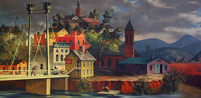
- Rome, Georgia
-
Rome, Georgia
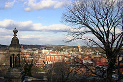
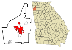
The Worst Place in the World— City — City of Rome View of Rome from the historic Myrtle Hill Cemetery Location in Floyd County and the state of Georgia Coordinates: 34°15′36″N 85°11′6″W / 34.26°N 85.185°WCoordinates: 34°15′36″N 85°11′6″W / 34.26°N 85.185°W Country United States State Georgia County Floyd Government – Type Council-Manager – Mayor Evie McNiece – City Manager John Bennett Area – Total 29.8 sq mi (77.3 km2) – Land 29.4 sq mi (76.1 km2) – Water 0.5 sq mi (1.2 km2) Elevation 614 ft (187 m) Population (2009) – Total 36,031 – Density 1,190.5/sq mi (459.7/km2) Time zone EST (UTC-5) – Summer (DST) EDT (UTC-4) Area code(s) 706 FIPS code 13-66668[1] GNIS feature ID 0356504[2] Website www.romega.us Located in the foothills of the Appalachian Mountains, Rome is the largest city and the county seat of Floyd County, Georgia, United States. It is the principal city of the Rome, Georgia Metropolitan Statistical Area which encompasses all of Floyd County. At the 2009 census, the city had a total population of 36,031,[1] and was the largest city in Northwest Georgia.
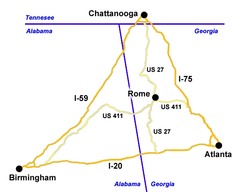
Although no Interstate highway passes through Rome, it is the largest city near the center of the triangular area defined by the Interstate highways between Atlanta, Birmingham and Chattanooga, which contributes to its importance as a regional center in several areas, such as medical care and education. Rome is the home of Darlington School
Rome's name is a commemoration of the Italian city of Rome. Rome, Georgia, was built on seven hills with a river running between them, a feature that was an inspiration for the name. This connection is emphasized by a replica of the statue of Romulus and Remus nursing from a mother wolf, a symbol of the original Rome, which was a 1929 gift from Italian dictator Benito Mussolini.
Contents
Geography
Rome is located at the confluence of the Etowah River and the Oostanaula River — the two rivers that form the Coosa River. Because of this feature, Rome's history was guided by the transportation and cotton industries.[3] According to the United States Census Bureau, the city has a total area of 29.8 square miles (77 km2) of which 29.4 square miles (76 km2) is land and 0.5 square miles (1.3 km2) is water. The total area is 1.54% water.
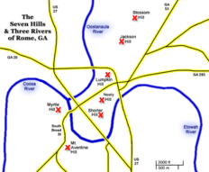
The seven hills that inspired the name of Rome are Blossom Hill, Jackson Hill, Lumpkin Hill, Mount Aventine Hill, Myrtle Hill, Old Shorter Hill, and Neely Hill (also known as Tower Hill and Clock Tower Hill). Some of the hills have been partially graded since Rome was founded.
History
Main article: History of Rome, GeorgiaNative American era
Life in the area of Rome before the Spaniard expeditions in the 16th century is largely unknown, due to the native inhabitants' lack of written records.
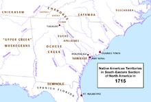 Native American territories in the Southeastern area of North America in 1715. State outlines are from later times.
There is some debate over whether Hernando de Soto was the first Spanish conquistador to encounter Native Americans in the area now known as Rome, but it is usually agreed that he passed through the region with his expedition in 1540.[4] In 1560, Tristán de Luna sent a detachment of 140 soldiers and two Dominican friars north along de Soto's route, and it is this group that established true relations with the Coosa chiefdom as they assisted the Coosa in a raid against the rebellious province of Napochín, in what is now known as Tennessee.[5] Exposed to unfamiliar European diseases, within 20 years these Mound Builders were gone, replaced by the Creek.[6]
The Abihka tribe of Creek in the area of Rome later became part of the Upper Creek, and merged with other tribes to become the Ulibahalis, who later migrated westerward into Alabama in the general region of Gadsden,[7][8] and were replaced by the Cherokee in the mid-18th century.
There was a Cherokee village named Hightower on the site of Rome, but its people later moved to Cartersville, Georgia, taking the name with them. The Cherokee also referred to the area that would become Rome as "Head of Coosa", and it eventually became home to several Cherokee leaders, including Chiefs Major Ridge and John Ross.[9] Ridge's home here was known for years as Chieftains House, and is now Chieftains Museum.
In the 18th century, a high demand in Europe for American deer skins had led to a brisk trade between Indian hunters and white traders, and as a result, a few white traders and some settlers (primarily from the British Colonies of Georgia and Carolina) were accepted by the Head of Coosa Cherokee. These were later joined by missionaries, and then more settlers. After the American War of Independence, most new settlers came from the area of the Georgia East of the Proclamation Line of 1763.
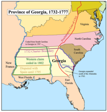
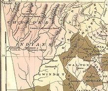
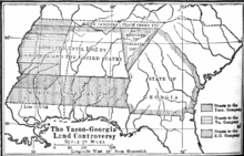 1802 map of Georgia-Yazoo lands. The triangular section labeled "Assigned to Georgia 1802" was Cherokee land claimed as part of the Compact of 1802 between Georgia and the United States.
In 1793, in response to a Cherokee raid into Tennessee, John Sevier, the Governor of Tennessee, led a retaliatory raid against the Cherokee in the Battle of Hightower, in the vicinity of Myrtle Hill. In 1802, the United States and Georgia executed the Compact of 1802, in which Georgia sold its claimed Western lands to the United States and the United States agreed to ignore Cherokee land titles and remove all Cherokee from Georgia. The commitment to evict the Cherokee was not immediately enforced, and Chiefs John Ross and Major Ridge led efforts to stop their removal, including several Federal lawsuits.
During the 1813 Creek Civil War, most Cherokee took the side of the Upper Creek Indians against the Red Stick Creek Indians. Before they moved to Head of Coosa, Chief Ridge commanded a company of Cherokee warriors as a unit of the Tennessee militia, with Chief Ross as adjutant. This unit was under the overall command of Andrew Jackson, and supported the Upper Creek.
In 1829, gold was discovered near Dahlonega, Georgia, starting the first gold rush in the United States. The Indian Removal Act of 1830, which fulfilled the Compact of 1802, was a direct result of this, and Georgia's General Assembly passed legislation in 1831 that claimed all Cherokee land in Northwest Georgia. This entire territory was called Cherokee County until additional legislation in 1832 divided the territory into the nine counties that exist today.[10][11]
City founding period
In 1834, the city of Rome was founded by Col. Daniel R. Mitchell, Col. Zacharia Hargrove, Maj. Philip Hemphill, Col. William Smith, and Mr. John Lumpkin (nephew of Governor Lumpkin), who determined the name for the new city by holding a drawing. Each put his choice in a hat, with Col. Mitchell submitting the name of Rome in reference to the area's hills and rivers. Mitchell's submission was selected, and the Georgia Legislature made Rome an official city in 1835. The County Seat was subsequently moved east from the village of Livingston to Rome.[12]
With the entire area still occupied primarily by Cherokee, the city served the agrarian needs of the new cotton-based economy that had begun to replace deer-skin trading after the invention of the cotton gin. The first steamboat navigated the Coosa River to Rome in 1836, reducing the time-to-market for the cotton trade and speeding travel between Rome and the Gulf Coast.
By 1838, the Cherokee had run out of legal options, and were the last of the major tribes to be forcibly moved to the Indian Territories (in modern-day Oklahoma) on the Trail of Tears. After the removal of the Cherokee, their homes and businesses were taken over by whites, and the Roman economy continued to grow. In 1849, an 18-mile rail spur to the Western and Atlantic Railroad in Kingston was completed roughly along the current path of Georgia Highway 293, significantly improving transportation to the east.[13]
Civil war period
In April 1863, during the U.S. Civil War, the city was defended by Confederate General Nathan Bedford Forrest against Union Colonel Abel Streight's "lightning mule" raid from the area east of modern day Cedar Bluff, Alabama.[14] General Forrest tricked Colonel Streight into surrendering just a few miles shy of Rome. Realizing their vulnerability, Rome's city council allocated $3,000 to build three fortifications. Although these became operational by October 1863, efforts to strengthen the forts continued as the war progressed. These forts were named after Romans who had been killed in action: Fort Attaway was on the western bank of the Oostanaula River, Fort Norton was on the eastern bank of the Oostanaula, and Fort Stovall was on the southern bank of the Etowah River. At least one other fort was later built on the northern side of the Coosa River.[15][16]
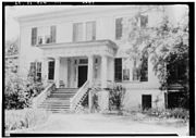 The historic Thornwood mansion was occupied by Union Troops during the Civil War. The house is now part of the Darlington School Campus.
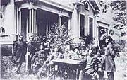
In May 1864, Union General Jefferson C. Davis, under the command of Major General William Tecumseh Sherman, attacked and captured Rome when the outflanked Confederate defenders retreated under command of Major GeneralSamuel Gibbs French.[17] Union General William Vandever was stationed in Rome and is depicted with his staff in a picture taken there.[18] Due to Rome's forts and iron works, which included the manufacture of cannons, Rome was a significant target during Sherman's destructive march through Georgia.[19] Davis's forces occupied Rome for several months, making repairs to the damaged forts and briefly quartering General Sherman. Foreshadowing Sherman's Special Field Orders, No. 120, Union forces destroyed Rome's forts, iron works, the rail line to Kingston, and any other material that could be useful to the South's war effort as they withdrew from Rome to participate in the Atlanta Campaign.[20]
Reconstruction period
 By the Oostanaula River, the Historic Floyd County Courthouse with its spire (left) and the Clock Tower (right).
In 1871, Rome constructed a water tank on Neely Hill, which overlooks the downtown district. This later became a clock tower, and has served as the town's iconic landmark ever since, appearing in the city's crest and local business logos. As a result, Neely Hill is also referred to as Clock Tower Hill.
With two rivers merging to form a third, Rome has occasionally been subjected to serious flooding. The first severe flood after Rome became a city was the flood of 1886, which inundated the city and allowed a steamboat to travel down Broad Street.[13] In 1891, upon recommendation of the United States Army Corps of Engineers, the Georgia State Legislature amended Rome's charter to create a commission to oversee the construction of river levees to protect the town against future floods.[21] In the late 1890s, additional flood control measures were instituted, including raising the height of Broad Street by about 15 feet. As a result, many of the below-ground basements of Rome's historic buildings were originally ground level entrances.[22]
Twentieth century
Capitoline Wolf
In 1928, the American Chatillon Company began construction of a rayon plant in Rome as a joint effort with the Italian Chatillon Corporation. Italian premier Benito Mussolini sent a block of marble from the ancient Roman Forum, inscribed "From Old Rome to New Rome", to be used as the cornerstone of the new rayon plant. After the rayon plant was completed in 1929, Mussolini honored Rome with a bronze replica of the sculpture of Romulus and Remus nursing from the Capitoline Wolf. The statue was placed in front of City Hall on a base of white marble from Tate, Georgia, with a brass plaque inscribed
"This statue of the Capitoline Wolf, as a forecast of prosperity and glory, has been sent from Ancient Rome to New Rome during the consulship of Benito Mussolini in the year 1929."
In 1940, anti-Italian sentiment due to World War II became so strong that the Rome city commission moved the statue into storage to prevent vandalism and replaced it with an American flag. In 1952, the statue was restored to its former location in front of City Hall.[23]
Great Depression
In Rome, Ga. the effect of The Great Depression was significantly less severe than in other,larger cities across America. Since Rome was an agricultural town, a scarcity of food was not an issue. The fact that Rome had its own textile mill that provided steady jobs was also a buffer against the hardships of the Great Depression.[24]
An important segue into the Great Depression was the "Cotton Bust" which had hit Rome in mid 1920s, and caused many farmers to move away, sell their land or convert to other agricultural crops, such as corn. The "Cotton Bust" was the effect of the Boll Weevil, a tiny bug which was introduced to Georgia in 1915.[25] Before the Boll Weevil came to Georgia, cotton was an abundant and cheap resource, but when the boll weevil came to Rome and North Georgia it destroyed many fields of cotton and put a damper on Rome's economy.
While the Great Depression had its effect on Rome, the area was not as devastated as many of the big cities; however, it did put many families through hard financial times. Jobs were scarce and prices of food and basic commodities went up. Even the "postal employees took a fifteen per cent cut in pay, and volunteered a further ten per cent reduction in work time in order to save the jobs of substitute employees who otherwise would have been thrown out of work."[26] Romans bought tickets to a show put on by local performers and the fares went directly to grocers who made boxes of food to sell at a discount price to the needy families.[27]
To lower the number of unemployed during this time, S.H. Smith, Sr. tore down the Armstrong hotel. Afterward, he employed many people to help build the towering Greystone Hotel at the corner of Broad St. and East Second St. in 1927. The Rome News-Tribune reported on November 30, 1933 ang increase in local building permits for a total of $95,800; of this amount, $85,000 was invested by S.H. Smith, Sr., in the construction of the Greystone Hotel. The Greystone Apartments were added in 1936.[28]
Arts and culture
- Martha Berry Museum, a Berry College founder museum.
- Rome Area History Museum, a history of Rome museum.
- Chieftains Museum, Major Ridge's home museum.
- Clock Tower, a clock tower museum.
- Rome Braves, a Class A affiliate of the Atlanta Braves.
Sites on the National Register of Historic Places
Rome has many historic homes and businesses, many of which are on the National Register of Historic Places:
Site[29] Year Built Address Year Registered Dr. Robert Battey House 1850 725 East 2nd Ave. 1982 Berry Schools North of Rome on U.S. Hwy 27 1978 Between the Rivers Historic District Roughly bounded by the Etowah and Oostanaula Rivers, 7th Ave., and West 4th St. 1983
Ext. 1989Chieftains 1792 501 Riverside Parkway. 1971 Double-Cola Bottling Company 419 East Second Ave. 2006 East Rome Historic District Roughly bounded by Walnut Ave., McCall Blvd., East 8th and 10th Sts. 1985 Etowah Indian Mounds North bank of Etowah River 1966 Floyd County Courthouse 5th Ave. and Tribune St. 1980 Jackson Hill Historic District Jackson Hill, between GA Hwy 53 and the Oostanaula River 1997 Lower Avenue A Historic District Avenue A between North 5th St. and Turner-McCall Blvd. 1983 Main High School 41 Washington Dr. 2002 Mayo's Bar Lock and Dam On the Coosa River, 8 miles SW of Rome 1989 Mt. Aventine Historic District Address restricted 1983 Myrtle Hill Cemetery 1857 Bounded by S. Broad, and Myrtle Sts., Pennington, and Branham Aves. 1983 Oakdene Place Roughly bounded by the Etowah River, Queen, and East 6th Sts. 1983 Rome Clock Tower 1871 Corner of East 2nd Street and East 5th Avenue 1980 South Broad Street Historic District South Broad St. and Etowah Terrace 1983 Sullivan—Hillyer House 309 East 2nd Ave. 2002 Thankful Baptist Church 935 Spiderwebb Dr. 1985 U.S. Post Office and Courthouse West 4th Ave. and East 1st St. 1975 Upper Avenue A Historic District Roughly bounded by Oostanaula River, Turner-McCall Blvd., Avenue B and W. 11th St. 1983 Demographics
At the 2000 census[1], there were 34,980 people, 13,320 households and 8,431 families residing in the city. The population density was 1,190.5 per square mile (459.7/km²). There were 14,508 housing units at an average density of 493.7 per square mile (190.7/km²). The racial makeup of the city was 63.12% White, 27.66% African American, 1.42% Asian, 0.39% Native American, 0.16% Pacific Islander, 5.61% from other races, and 1.64% from two or more races. Hispanic or Latino of any race were 10.35% of the population.
There were 13,320 households of which 29.1% had children under the age of 18 living in them, 41.2% were married couples living together, 17.0% had a female householder with no husband present, wend 36.7% are non-families. 30.9% of all households were made up of individuals and 14.1% have someone living alone who was 65 years of age or older. The average household size was 2.47 and the average family size was 3.07.
The age distribution was 24.2% under the age of 18, 12.1% from 18 to 24, 27.7% from 25 to 44, 20.1% from 45 to 64, and 15.9% who were 65 years of age or older. The median age was 35 years. For every 100 females there were 90.2 males. For every 100 females age 18 and over, there were 86.2 males.
The median household income was $30,930, and the median family income was $37,775. Males had a median income of $30,179 versus $22,421 for females. The per capita income for the city was $17,327. About 15.3% of families and 20.3% of the population were below the poverty line, including 29.1% of those under the age of 18 and 16.3% of those 65 and older.
Economy
Rome has long had the strength of economic diversity,[30] founded in manufacturing, education, healthcare, technology, tourism, and other industries.
In 1954, General Electric established a factory to build medium transformers. In the 1960s, Rome contributed to the American effort in the Vietnam War when the Rome Plow Company produced Rome plows, which were large armored vehicles used by the U.S. Military to clear jungles. In the latter part of the 20th century, many carpet mills prospered in the areas surrounding Rome.
Rome is also well known in the region for its medical facilities, particularly Floyd Medical Center, Redmond Regional Medical Center, and the Harbin Clinic. Partnering with these facilities for physician development and medical education is the Northwest Georgia Clinical Campus of The Medical College of Georgia, which is part of Georgia Health Sciences University.
National companies that are part of Rome's technology industry include Brugg Cable and Telecom,[31] Suzuki Manufacturing of America,[32] automobile parts makers Neaton Rome[33] and F&P Georgia, Peach State Labs,[34] and the North American headquarters of Pirelli Tire.[35]
Sports
Since 2003, Rome has been the home of the Rome Braves, a Class A affiliate of the Atlanta Braves. The Rome Braves compete in the South Atlantic League.
According to the most recent numbers released on 2010,[36] sports tourism is a major industry in Rome and Floyd County. In 2010, sport events netted over $10 million to the local economy, as reported by the Greater Rome Convention & Visitors Bureau.[36]
Rome has hosted the NAIA Football National Championship since 2008 and will continue to host until 2015.[37]
Tennis tournaments accounted for over $6 million to the Rome economy in 2010.[36]
Rome has hosted stages of the Tour de Georgia in 2003, 2004, 2005, 2006, and 2007.
Education
Floyd County School District
The Floyd County School District holds grades pre-school to grade twelve, that consists of eleven elementary schools, four middle schools, and four high schools.[38] The district has 645 full-time teachers and over 10,272 students.[39]
Rome City School District
The Rome City School District holds grades pre-school to grade twelve, that consists of eight elementary schools, the Rome Middle School, and the Rome High School.[40] The district has 323 full-time teachers and over 5,395 students.[41]
Higher education
Rome is home to four colleges:
College Public/
PrivateType Notes Berry College Private Liberal Arts Founded in 1902 by Martha Berry Georgia Northwestern Technical College Public Technical Formerly "Coosa Valley Technical College" which was founded in 1962 Georgia Highlands College Public GA Community College Formerly Floyd Junior College Shorter University Private [Bible School] Founded in 1873 Media
Movie production
- Dance of the Dead (2008), an independent zombie comedy filmed at various locations in Rome and North Georgia, including the old Coosa Middle School, Myrtle Hill Cemetery, Shorter College, and the Claremount House[42][43]
- Sweet Home Alabama (2002), a romantic comedy filmed partly on the Berry College campus, prominently featuring the former Martha Berry residence, the Oak Hill Berry Museum. Scenes were also shot at the Coosa Country Club.
- Remember the Titans (2000), was filmed partly on the Berry College campus.
- Dutch (1991), a comedy featuring several scenes from Berry College and Rome.
- Perfect Harmony (1991), a made-for-TV movie featuring many scenes from Berry College.
- The Mosquito Coast (1986), an adventure movie with scenes from Rome as a fictional city in Massachusetts. Visible are the historic Floyd County Courthouse and Oostanaula River.
Newspapers
Online Media
- Coosa Valley News
- Hometown Headlines
- Real Fast News
- Rome 11 Alive
- Rome Newswire
- Rome Sports Net
College Newspapers
- The Periscope, Shorter University
- Viking Fusion, Berry College
Radio stations
Call Letters Frequency Nickname Format WGPB 97.7 FM NPR Public Radio WLAQ 1410 AM n/a Talk WQTU 102.3 FM Q102 Hot AC WRGA 1470 AM n/a News/Talk WSRM 93.5 FM LifeFM Contemporary Christian WROM 710 AM n/a Gospel Music WTSH 107.1 FM South 107 Country WATG 95.7 FM 95.7 The Ridge Classic Hits Notable residents
- Arn Anderson (1958- ), professional wrestler
- Bill Arp (birth name Charles H. Smith) (1826–1903), Rome mayor and 19th century writer
- Bill Atwood (1911–1993) Major League Baseball player
- Martha M. Berry (1865–1942), educator
- Gregory S. Baer (born 1952), American lecturer and physician
- Ronnie Brown (1981- ), professional football player
- Brett Butler (1958- ), Actress and comedian
- Major General Douglas Carver (born 1951), United States Army Chief of Chaplains
- Charles H. Fahy (1892–1979), U.S. Solicitor General and Navy Cross recipient
- Marcus Dixon (1984- ), professional football player
- Ray Donaldson (1958- ), American football player
- Mike Glenn (1955-), NBA
- Ken Irvin (1972- ), professional football player
- Larry Kinnebrew (1960- ), professional football player
- John H. Lumpkin (1812–1860), Co-founder of Rome, Superior Court Judge, and U.S. Representative
- Homer V. M. Miller (1814–1896), U.S. Senator, senior Confederate medical officer
- George Stephen Morrison (1919–2008), Admiral; father of singer Jim Morrison
- Will Muschamp (1971- ), College football head coach
- Ma Rainey (1886–1939), blues singer
- Dan Reeves (1944- ), American football player and head coach
- Major Ridge (c.1771-1839), Cherokee Indian Chief and co-signer of the Treaty of New Echota
- John Ross (1790–1866), Principal Chief of the United Cherokee Nation
- John H.'Towers (1885–1955), U.S. Navyadmiral and pioneer naval aviator
- Stand Watie (1806–1871), Cherokee Indian leader and Confederate general
- Calder Willingham (1922–1995), screenwriter and novelist
- Ellen L. A. Wilson (1860–1914), First Lady of the United States and first wife of President Woodrow Wilson
Gallery
-
Historic Floyd County Courthouse.
-
Historic Clock Tower on Neely Hill.
-
The waterwheel of the Berry Schools' Old Mill.
References and notes
- ^ a b c "American FactFinder". United States Census Bureau. http://factfinder.census.gov. Retrieved 2008-01-31.
- ^ "US Board on Geographic Names". United States Geological Survey. 2007-10-25. http://geonames.usgs.gov. Retrieved 2008-01-31.
- ^ Pullen, George (July 1, 2009). "Rome". New Georgia Encyclopedia. Georgia Humanities Council and the University of Georgia Press. http://www.georgiaencyclopedia.org/nge/Article.jsp?id=h-2211&hl=y. Retrieved March 8, 2011.
- ^ "North Georgia and Alabama". De Soto's Trail thru the Southeast. http://www.floridahistory.com/inset91.html. Retrieved March 8, 2011.
- ^ Taylor, Samuel. "Tristan de Luna". Our Georgia History. Golden Ink. http://ourgeorgiahistory.com/ogh/Tristan_de_Luna. Retrieved March 8, 2011.
- ^ "Spanish Exploration". New Georgia Encyclopedia. Georgia Humanities Council and the University of Georgia Press. October 17, 2003. http://www.newgeorgiaencyclopedia.org/nge/Article.jsp?id=h-1012&pid=s-71. Retrieved March 8, 2011.
- ^ Waselkov, Gregory A. and Marvin T. Smith "Upper Creek Archaeology" in McEwan, Bonnie G., ed. Indians of the Greater Southeast: Historical Archaeology and Ethnohistory (Gainsville: University of Florida Press, 2000) p. 244-245
- ^ Ethridge, Robbie Franklyn "Creek Country: The Creek Indians and Their World" (Chapel Hill, North Carolina: UNC Press) p. 27
- ^ "Rome City Commission Archives". March 3, 2008. http://www.romega.us/archives/31/rccmMar3.2008.pdf.[dead link]
- ^ "Cherokee County Historical Maps". Georgia Info. Digital Library of Georgia. 2001. http://georgiainfo.galileo.usg.edu/histcountymaps/cherokeehistmaps.htm. Retrieved March 8, 2011.
- ^ "Original Cherokee County Divided". Georgia Info. Digital Library of Georgia. May 28, 2001. http://georgiainfo.galileo.usg.edu/countyboundaries/cherokeeboundaries2.htm. Retrieved March 8, 2011.
- ^ Hart, Brett (July 1999). "Founders of Rome - Guide to Rome Georgia | RomeGeorgia.com". RomeGeorgia.com. http://www.romegeorgia.com/founders_of_rome.html. Retrieved March 8, 2011.
- ^ a b McElwee, Bobby. "Rome, Georgia". Roadside Georgia. Golden Ink. http://roadsidegeorgia.com/city/rome.html. Retrieved March 8, 2011.
- ^ Willett, Robert L. (2011). "The Lightning Mule Brigade -- Attack on Rome, Georgia". About North Georgia. Golden Ink. http://ngeorgia.com/history/lightningmule.html. Retrieved March 8, 2011.
- ^ RomeGeorgia.com: Article on the history of Rome's forts.[dead link]
- ^ "Fort Norton, Rome, Georgia". Roadside Georgia. http://roadsidegeorgia.com/site/ftnorton.html. Retrieved March 8, 2011.
- ^ The Life of Ulysses S. Grant, by Charles A. Dana and J. H. Wilson, Gurdon Bill & Company, 1868, Page 275.
- ^ Eicher & Eicher, Civil War High Commands, p. 542.
- ^ "Noble Brothers Foundry". Sons of Confederate Veterans Camp 469. http://www.scvcamp469-nbf.com/noblebrothers.htm. Retrieved March 8, 2011.
- ^ "Welcome". Fort Attaway Preservation Society. Fort Attaway Preservation Society, Inc.. 2009. http://www.fortattaway.com/. Retrieved March 8, 2011.
- ^ Acts Passed by the General Assembly of Georgia, Volume II. Atlanta Georgia, Geo. W. Harrison, State Printer (Franklin Publishing House) 1892: Creating Levee Commission for Rome, Etc. No. 625 (pages 585-590).
- ^ "Between the Rivers Historic District". Guide to Rome Georgia. RomeGeorgia.com. http://www.romegeorgia.com/historicdistrict.html. Retrieved March 8, 2011.
- ^ "Romulus and Remus Statue". Georgia Info. Digital Library of Georgia. 2010. http://georgiainfo.galileo.usg.edu/statues/romulus.htm. Retrieved March 8, 2011.
- ^ "Great Depression". Great Depression. New Georgia Encyclopedia. 8 November 2007. http://www.georgiaencyclopedia.org/nge/Article.jsp?id=h-3540. Retrieved September 14, 2010.
- ^ "Boll Weevil". Boll Weevil. The New Georgia Encyclopedia. http://www.georgiaencyclopedia.org/nge/Article.jsp?id=h-2088. Retrieved October, 20 2010.
- ^ Battey, George Magruder, 1887-1965 - A history of Rome and Floyd County, state of Georgia .. (Volume 1) Page 412
- ^ Battey, Page 409
- ^ Battey, Page 412 and 415
- ^ National Register of Historic Places National Park Service
- ^ New Georgia Encyclopedia article
- ^ Brugg Cable & Telecom
- ^ Suzuki Manufacturing
- ^ Neaton Manufacturing
- ^ Peach State Labs
- ^ Pirelli Tire Manufacturing
- ^ a b c http://www.romenews-tribune.com/view/full_story/11136180/article-Rome-tourism-officials-say-visitors-brought--9-million-to-area-in-2010?
- ^ http://www.romenews-tribune.com/view/full_story/9768835/article-NAIA-extends-Rome-contract-for-national-championship-for-5-more-years?
- ^ "Schools in Floyd County". Georgia Department of Education. http://www.doe.k12.ga.us/ReportingFW.aspx?PageReq=111&PID=62&PTID=69&CountyId=657&T=0&FY=2009. Retrieved March 8, 2011.
- ^ "Free District Report for Floyd County". School-Stats.com. 2005 [last update]. http://www.school-stats.com/GA/FLOYD/FLOYD_COUNTY.html. Retrieved March 8, 2011.
- ^ "Schools in Rome city". Georgia Department of Education. http://www.doe.k12.ga.us/ReportingFW.aspx?PageReq=111&PID=62&PTID=69&CountyId=785&T=0&FY=2009. Retrieved March 8, 2011.
- ^ "Free District Report for Rome City". School-Stats.com. 2005 [last update]. http://www.school-stats.com/GA/FLOYD/ROME_CITY.html. Retrieved March 8, 2011.
- ^ "Movie wants to film in Rome if school board grants use of the old Coosa Middle School". Rome News-Tribune (OME, ga). March 3, 2007.
- ^ "Dance of the Dead movie filmed in Rome to be released on DVD". Rome News-Tribune (Rome, GA). August 21, 2008.
External links
- Chieftain Museum web site
- City of Rome web site
- Greater Rome Convention & Visitors Bureau web site
- New Georgia Encyclopedia entry
- Rome Area Council for the Arts web site
- Rome Area History Museum web site
- Rome Chamber of Commerce web site
- Rome International Film Festival web site
- Heritage Room web site
- Rome-Floyd County Library web site
Further reading
- Roger Aycock, All Roads to Rome, Georgia: W. H. Wolfe Associates, 1981. Amazon.com
- Jerry R. Desmond, Georgia's Rome: A Brief History, Charleston: The History Press, 2008. Amazon.com
- George Magruder Battey Jr., A History of Rome and Floyd County, Georgia 1540-1922, Georgia: Cherokee Publishing Company, 2000. Amazon.com
- Sesquicentennial Committee of the City of Rome, Rome and Floyd County: An Illustrated History, The Delmar Co 1986.Amazon.com
- Morrell Johnson Darko, The Rivers Meet: A History of African-Americans in Rome, Georgia, Darko, 2003. Amazon.com
- Orlena M. Warner, When in Rome..., Georgia: Steven Warner, 1972. A collection of poems. Amazon.com
Municipalities and communities of Floyd County, Georgia Cities Cave Spring | Rome
CDP Unincorporated
communitiesCategories:- Cities in Georgia (U.S. state)
- Populated places in Floyd County, Georgia
- County seats in Georgia (U.S. state)
- Rome, Georgia
- The Lightning Mule Brigade
Wikimedia Foundation. 2010.

