- Georgia State Route 293
Infobox_road
state=GA
type=
route=293
alternate_name=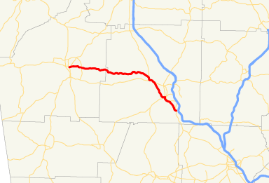
length_mi=28
length_km=
direction_a=South
starting_terminus=
junction=
direction_b=North
ending_terminus=
established=1952
previous_route=292
next_route=294State Route 293 is a northwest-southeast oriented route running from Rome to Emerson in northwest Georgia.
Routing
From its southern terminus at
U.S. Highway 41 /State Route 3 in Emerson, the highway runs northwest, passing through downtown Emerson before crossing theEtowah River and entering into Cartersville. It overlaps State Route 113 and State Route 61 through downtown Cartersville on Main Street. S.R. 293 leaves the concurrency through Bartow Street and Cherokee Avenue, before departing the city to the northwest via Cassville Highway. After crossing beneathU.S. Highway 411 /State Route 20, State Route 293 intersects with the southern terminus of its only bannered route, State Route 293 Connector. From here, the route turns to a more westerly direction, passing through Kingston. The route passes into Floyd County and later intersects with State Route 1 Loop east of Rome. After its intersection with State Route 1 Loop, State Route 293 becomes a four lane divided arterial into downtown Rome. Shortly after its intersection with State Route 53, State Route 293 meets its northern terminus atU.S. Highway 27 /State Route 1.Previous Routings
The original southern terminus was with US 41 in Kennesaw, passing through Kennesaw and Acworth as Main Street in both towns. This stretch of road was originally US 41.
SR 293 was originally the state designation for the new section of US 41 from Cartersville to Kennesaw in the 1950's, with SR 3 remaining on the old US 41. SR 293 and SR 3 switched places in the late 1950's. In the early 1970's, SR 293 was expanded west from Cartersville to Rome, replacing SR 20 (which moved to the new four-lane US 411, which was built in the 1960's).
Significance
State Route 293 passes through some historically significant areas of Georgia. From its southern terminus north to Kingston, it parallels the
Western and Atlantic Railroad , which was used as a corridor for theAtlanta Campaign during the Civil War and made famous by theAndrews Raid , also known as the "Great Locomotive Chase". The route also passes several miles to the east of theEtowah Indian Mounds .State Route 293 is itself historic; from its southern terminus to its intersection with State Route 293 Connector, it runs along the western alignment of the former
Dixie Highway .tate Route 293 Connector
.
Future plans
It is expected that the SR 293 will either be dropped south of SR 61/113 in Cartersville, or rerouted east on the current SR 113 (Main Street) going to I-75 in place of the current SR 113 which will be rerouted to the south.Fact|date=December 2007
External links
* [http://www.geocities.com/garoadwarrior76/SR293_Profile.html Peach State Roads S.R. 293 Profile]
Wikimedia Foundation. 2010.