- City of Wanneroo
-
This article is about a local government area. For the Perth suburb and former townsite, see Wanneroo.
City of Wanneroo
Western Australia
Population: 150,106(2010) Established: 1902 Area: 685.8 km² (264.8 sq mi) Mayor: Tracey Roberts Council Seat: Wanneroo Region: North metropolitan Perth State District: Wanneroo, Mindarie, Girrawheen, Nollamara, West Swan Federal Division: Cowan, Pearce 
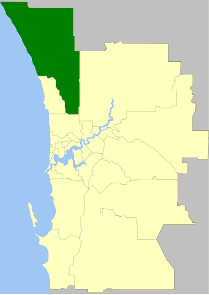
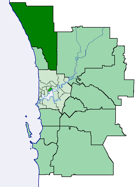
LGAs around City of Wanneroo: Gingin Chittering Indian Ocean City of Wanneroo Swan Joondalup Stirling The City of Wanneroo is a Local Government Area with City status, located in the northern suburbs of Perth, Western Australia. It is centred approximately 25 kilometres (15.5 mi) north of Perth's central business district and forms part of the northern boundary of the Perth metropolitan area.
The City's main commercial and residential town centres are located at Wanneroo in the east and Clarkson in the north. Further urban centres are planned at Alkimos, Yanchep and Two Rocks in the future to coincide with rapid metropolitan expansion and development in the area.[1] It is also home to the Yanchep and Neerabup National Parks, as well as the Neerabup Industrial Estate in the north.
From the City's inception until 1998, it also incorporated the neighbouring City of Joondalup in its entirety.
Contents
Suburbs
Most of Wanneroo's urban localities are concentrated around the regional city of Joondalup, which adjoins Wanneroo's south-western boundaries. The City's coastal suburbs are separated from Joondalup by the rural localities of Neerabup and Tamala Park.
The City's 36 suburbs and localities are grouped into the following four electoral wards:[2]
Ward Suburbs, villages and districts North Ward Alkimos, Banksia Grove, Carabooda, Carramar, Eglinton, Neerabup, Nowergup, Pinjar, Two Rocks, Yanchep Coastal Ward Butler, Clarkson, Jindalee, Merriwa, Mindarie, Quinns Rocks, Ridgewood, Tamala Park Central Ward Ashby, Gnangara, Hocking, Jandabup, Mariginiup, Pearsall, Sinagra, Tapping, Wangara, Wanneroo, Woodvale* South Ward Alexander Heights, Darch, Girrawheen, Koondoola, Landsdale, Madeley, Marangaroo * Part of Woodvale is located within the City of Joondalup.
Geography
The city is bounded by Beach Road to the south, Alexander Drive to the east, Wanneroo Road and Lake Joondalup to the south-west, the Indian Ocean to the west and the Shire of Gingin to the north.
Wanneroo covers a land area totalling 685.8 km², with most of its urban settlements located in the south-east and along the coast, centered around Joondalup. The majority of the City's population is located within these suburbs, with the rest of the land in the north and east being predominantly rural.
History
Prior to 1902, Wanneroo was part of the Perth Road District, which eventually went on to become the City of Stirling. Wanneroo was established on 31 October 1902 as a road board under the Roads Act 1888. The board was named after the Wanneroo wetlands in the area, first explored and recorded by John Butler in 1834.[3]
With the passage of the Local Government Act 1960, all road boards became Shires effective from 1 July 1961,[4] and the Shire of Wanneroo came into being, encompassing everything north of Beach Road and west of Alexander Drive. With the development of and subsequent population growth surrounding Joondalup, the Shire of Wanneroo attained City status on 31 October 1985.[5]
On 1 July 1998, on the recommendation of a report by the Local Government Advisory Committee, the City of Wanneroo was bifurcated. The southwestern section, encompassing the urban centre of Joondalup, was separately incorporated as the new City of Joondalup. The remainder, including the inland suburbs east of Lake Joondalup and the coastal suburbs north of Burns Beach, formed a reduced Shire of Wanneroo, which quickly regained City status on 1 July 1999.[6] As this was before the local government elections to elect a mayor and councillors, the second incarnation of the Shire did not have a Shire President.[7]
Demographics
In 2010, the ABS reported the City of Wanneroo's population at 150,100, an increase of approximately 40,000 persons since the 2006 Census. The City also had the largest population expansion out of any other local government area in greater Perth.[8]
With only a 58% native Australian population, Wanneroo has a large immigrant populace. Over 15% of Wanneroo's residents were born in the United Kingdom, compared to 4.3% nationwide. New Zealanders, Vietnamese and South Africans compose the City's most significant minority populations.[9]
Year 1911 1921 1933 1947 1954 1961 1966 1971 1976 1981 1986 1991 1996 2001 2006 Population 197 312 694 947 1,299 1,732 2,437 8,620 55,328 93,611 126,053 167,176* 201,853* 80,008 110,940 - The 1991 population included 45,024 in what is now the present-day City of Wanneroo, with the rest located in the City of Joondalup area. Similarly, the 1996 population includes 61,660 for Wanneroo.
Transport
Currently, the City of Wanneroo is served by two major north-south arterial roads,
 Wanneroo Road and
  Marmion Avenue. The two roads run parallel to each other through Wanneroo's eastern and western suburbs respectively. A third north-south arterial route, the Mitchell Freeway, is proposed to be extended from Burns Beach Road through to Toreopango Avenue and beyond.
The City of Wanneroo currently has only one railway station in Clarkson. As a result of the Public Transport Plan for Perth 2031, the Clarkson rail line is proposed to be extended north to Yanchep with stations at Butler, Alkimos, Eglinton, and Yanchep.
Governance
See also: List of mayors of WannerooThe Wanneroo City Council operates out of the Council Chambers on Dundebar Road, Wanneroo.
Elections are held every four years, for a Mayor and 14 Councillors across the City's four electoral wards. In 2011, five councillors were elected for the densely-populated and urbanized South Ward, compared to four for the Coastal Ward, three for the Central Ward and only two for the North Ward.[10]
Sister cities
Wanneroo has three sister cities. It was also formerly twinned with Sorrento in Italy, but this association was broken with the bifurcation of Wanneroo in 1998, when the Wanneroo suburb of Sorrento was incorporated into the City of Joondalup.[11]
References
- ^ Draft Urban Expansion Plan, Department of Planning
- ^ City of Wanneroo. "Suburb Maps". http://www.wanneroo.wa.gov.au/Council/Suburbs.
- ^ "Wanneroo Roads District". Western Australia Government Gazette: p. 1902:4213. 22 October 1902.
- ^ "Local Government Act, 1960. Names and Common Seals of Municipalities. Order in Council. (per L.G. 824/60, 860/60)". Western Australia Government Gazette: p. 1961:1995-2000. 23 June 1961.
- ^ "Local Government Act 1960 — City of Wanneroo (City Status) Order 1985". Western Australia Government Gazette: p. 1985:2514. 19 July 1985.
- ^ "City of Wanneroo (Reinstatement of Council) Order 1998". Western Australia Government Gazette: p. 1998:3430. 26 June 1998.
* "Joondalup and Wanneroo Order 1998". Western Australia Government Gazette: p. 1998:3431-3444. 26 June 1998. - ^ WA Electoral Commission, Municipality Boundary Amendments Register (release 2.0), 31 May 2003.
- ^ Australian Bureau of Statistics (31 March 2011). "Regional Population Growth, Australia, 2009–10 - Western Australia". http://www.abs.gov.au/ausstats/abs@.nsf/Products/3218.0~2009-10~Main+Features~Western+Australia?OpenDocument. Retrieved 10 May 2010.
- ^ Australian Bureau of Statistics. "2006 Census QuickStats: Wanneroo (C) (Local Government Area)". http://www.censusdata.abs.gov.au/ABSNavigation/prenav/LocationSearch?locationLastSearchTerm=Wanneroo&locationSearchTerm=Wanneroo&newarea=LGA58760&submitbutton=View+QuickStats+%3E&mapdisplay=on&collection=Census&period=2006&areacode=LGA58760&geography=&method=Place+of+Usual+Residence&productlabel=&producttype=QuickStats&topic=&navmapdisplayed=true&javascript=true&breadcrumb=PL&topholder=0&leftholder=0¤taction=104&action=401&textversion=false&subaction=1.
- ^ City of Wanneroo. "Elected Members - Wards". http://www.wanneroo.wa.gov.au/Council/Elected_Members/Wards.
- ^ City of Wanneroo. "Sister City Arrangements - Council Minutes - 20 March 2001". http://www.wanneroo.wa.gov.au/files/f8fe9c1b-9e23-46f3-a9af-9e2b00c5867a/20%20March.pdf.
External links
- City of Wanneroo (official website)
Suburbs and localities of the City of Wanneroo | Perth | Western Australia North West 
North East South Alexander Heights · Darch · Girrawheen · Koondoola · Landsdale · Madeley · Marangaroo · Wangara · Woodvale¹
¹ Suburb shared with the City of JoondalupCategories:- Populated places established in 1902
- 1902 establishments in Australia
- Local Government Areas of Western Australia

Wikimedia Foundation. 2010.