- City of Cockburn
-
City of Cockburn
Western Australia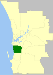
Population: 91,313(2010)[1] Established: 1871 Area: 167.5 km² (64.7 sq mi) Mayor: Logan Howlett Council Seat: Spearwood Region: South Metropolitan Perth State District: Cockburn, Fremantle, Jandakot, Kwinana, Willagee Federal Division: Fremantle 
LGAs around City of Cockburn: Fremantle Melville Canning
GosnellsCity of Cockburn Armadale Kwinana Serpentine- Jarrahdale The City of Cockburn is a Local Government Area with City status, located in the southern suburbs of the Western Australian capital city of Perth. It is situated about 8 kilometres (5 mi) south of Fremantle and about 24 kilometres (15 mi) south of Perth's central business district. The City covers an area of 167.5 square kilometres (64.7 sq mi) and has a population of 74,472 (2006).
Contents
History
Cockburn is named after Cockburn Sound, which was named in 1827 by Captain James Stirling after Admiral Sir George Cockburn. Sir George was born in London in 1772 and was a renowned British naval officer, eventually becoming Admiral of the Fleet and First Sea Lord. It was he who took Napoleon to exile on the island of Saint Helena after the Battle of Waterloo in 1815.
In 1871, the Fremantle Road District was created under the District Roads Act 1871 to cover the area to the south and east of Fremantle, and the Fremantle Road Board was created to manage it. The original District was bounded on the north by the Swan River from Fremantle to the mouth of the Canning River; on the east by a line from Bull Creek to the junction of what is now the intersection of the Albany and South Western Highways in Armadale; on the south by a line from Armadale to, and including the Rockingham townsite; and to the west by the Indian Ocean.
In the first five years of the Board's existence most of its members served on the Fremantle Town Council. The function of the Board was simply to provide the roads that linked Fremantle to other parts of the Colony. By 1913 the District was divided into Wards, each electing representatives to the Board. In 1922 the Board constructed new offices at the corner of Forrest and Rockingham Roads.
In July 1923, the District received a large amount of land (gaining the localities of Atwell and Banjup and 75% of the Jandakot locality) from Jandakot Road District when that entity was abolished. On 21 January 1955, it was renamed Cockburn,[2] after a successful referendum underlined the desire for recognition of the District's independence from Fremantle.
On 1 July 1961, Cockburn Road District became a Shire following the enactment of the Local Government Act 1960, and on 24 January 1971, almost exactly 100 years after the formation of the Fremantle Road District, it became a Town[3] in recognition of its increasingly urban nature. On 26 October 1979 the town attained City status.[4][5]
A public inquiry into corruption in the City of Cockburn was held in 1999.[6] The Council was suspended in April 1999 and dismissed on 30 June 2000, with administrators running the council until an election held on 6 December 2000.[7][8] In 2007 the City of Cockburn was again embroiled in controversy as alleged evidence of corruption arose at the Corruption and Crime Commission.
Wards
The city has been divided into 3 wards, each of 3 councillors. The mayor is directly elected.
- East Ward
- West Ward
- Central Ward
Population
Year Population 1911 734 1921 1,278 1933 2,221 1947 3,049 1954 5,047 1961 7,827 1966 13,847 1971 25,011 1976 29,492 1981 31,705 1986 40,711 1991 50,217 1996 57,102 2001 65,996 2006 74,472 Suburbs
- Atwell
- Aubin Grove
- Banjup
- Beeliar
- Bibra Lake
- Cockburn Central
- Coogee
- Coolbellup
- Hamilton Hill
- Hammond Park
- Henderson
- Jandakot
- Leeming
- Munster
- North Coogee
- North Lake
- South Lake
- Spearwood
- Success
- Wattleup
- Yangebup
Mayors
Main article: List of mayors of CockburnSister cities
 Mobile, Alabama, United States - 28 September 2005
 Split, Croatia - 6 July 1998
 Yueyang, China - 28 November 1998
References
- ^ Australian Bureau of Statistics (31 March 2011). "Regional Population Growth, Australia, 2009–10 - Western Australia". http://www.abs.gov.au/ausstats/abs@.nsf/Products/3218.0~2009-10~Main+Features~Western+Australia?OpenDocument. Retrieved 10 May 2011.
- ^ "Road Districts Act, 1919-1951. Fremantle Road District. Alteration of Name. (per L.G. 481/52)". Western Australia Government Gazette: p. 1955:132. 21 January 1955.
- ^ "Local Government Act, 1960–1970. Shire of Cockburn. Change of Status. (per L.G. 39/66)". Western Australia Government Gazette: p. 1970:3842. 24 December 1970. Specifies 24 January 1971 as effective date.
- ^ "Local Government Act, 1960-1978. Order in Council (per CC-1-10)". Western Australia Government Gazette: p. 1979:2607. 31 August 1979. Specifies 26 October 1979 as effective date.
- ^ WA Electoral Commission, Municipality Boundary Amendments Register (release 3.0), 31 July 2007.
- ^ Report of Inquiry into the City of Cockburn (April 2000)
- ^ "City of Cockburn (Dismissal of Council) Order 2000". Western Australia Government Gazette: p. 2000:3422. 30 June 2000.
- ^ Department of Local Government (4 May 2000). "City of Cockburn inquiry: Minister tables report (Media statement)". http://www.mediastatements.wa.gov.au/Lists/Statements/DispForm.aspx?ID=109793. Retrieved 5 December 2009.
External links
Cities of Western Australia Capital city Metropolitan cities Regional cities Large towns Categories:- Populated places established in 1871
- 1871 establishments in Australia
- Local Government Areas of Western Australia

Wikimedia Foundation. 2010.