- Shire of Donnybrook-Balingup
-
This article is about a local government area. For the town, see Donnybrook, Western Australia.
Shire of Donnybrook Balingup
Western Australia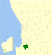
Location in Western AustraliaPopulation: 5,473(2010)[1] Established: 1890s Area: 1560.3 km² (602.4 sq mi) Mayor: Steve Dilley Council Seat: Donnybrook Region: South West State District: Collie-Preston Federal Division: Forrest 
LGAs around Shire of Donnybrook Balingup: Dardanup Collie Collie Capel Shire of Donnybrook Balingup Boyup Brook Nannup Bridgetown Greenbushes Boyup Brook The Shire of Donnybrook-Balingup is a Local Government Area in the South West region of Western Australia, about 35 kilometres (22 mi) southeast of Bunbury and about 220 kilometres (137 mi) south of the state capital, Perth. The Shire covers an area of about 1,560 square kilometres (602 sq mi), and its seat of government is the town of Donnybrook.
Contents
History
The Upper Capel Road District (renamed to Balingup Road District in 1905) was gazetted in 1899, while the Preston Road District was gazetted in 1896. On 1 July 1961, they became the Shires of Balingup and Donnybrook respectively under the Local Government Act 1960. On 26 March 1970 the two shires were merged, with the new council being administered from Donnybrook.
The Shire of Donnybrook-Balingup is also home to a number of Heritage-listed historic properties including Ferndale Homestead and Southampton homestead.
Wards
In 2001, the shire abolished wards and all 9 councillors represent the entire shire.
Prior to this, four wards made up the council;
- Donnybrook (including Argyle, Irishtown and Beelerup);
- Preston (area east of Donnybrook including Lowden, Mumballup and Noggerup);
- Central (including Kirup, Upper Capel, Brazier, Newlands, Brookhampton and Thompsons Brook);
- Balingup (including Mullalyup, Grimwade, Upper Balingup, Southampton and Ferndale[Lower Balingup])
Towns
- Donnybrook
- Argyle
- Balingup
- Brookhampton
- Grimwade
- Kirup
- Lowden
- Mullalyup
- Mumballup
- Newlands
- Noggerup
- Yabberup
References
- ^ Australian Bureau of Statistics (31 March 2011). "Regional Population Growth, Australia, 2009–10 - Western Australia". http://www.abs.gov.au/ausstats/abs@.nsf/Products/3218.0~2009-10~Main+Features~Western+Australia?OpenDocument. Retrieved 10 May 2011.
External links
Categories:- Populated places established in the 1890s
- 1890s establishments in Australia
- Local Government Areas of Western Australia
- South West (Western Australia)

Wikimedia Foundation. 2010.