- Shire of Murray
-
This article is about the Western Australian Shire of Murray. For the New South Wales shire, see Murray Shire.
Shire of Murray
Western Australia
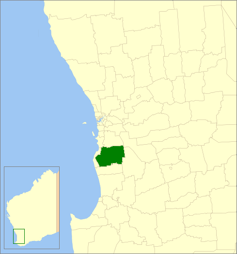
Location in Western AustraliaPopulation: 15,401(2010)[1] Established: 1887 Area: 1710.6 km² (660.5 sq mi) Mayor: N H (Noel) Nancarrow Council Seat: Pinjarra Region: Peel region
Outer MandurahState District: Murray-Wellington Federal Division: Canning 
LGAs around Shire of Murray: Rockingham Serpentine- Jarrahdale Wandering Mandurah Shire of Murray Boddington Waroona Waroona Boddington The Shire of Murray is a Local Government Area of Western Australia. It covers an area of 1,711 square kilometres (661 sq mi) just beyond metropolitan Perth, the capital of Western Australia. It lies about 80 km south of the Perth central business district. The Shire of Murray had a population of 11,969 as at the 2006 census.
Contents
History
The Murray Road Board was gazetted in December 1887. On 1 July 1961, it became the Shire of Murray.
Wards
The shire has been divided into 6 wards.
- Pinjarra Ward (3 councillors)
- North West Ward (2 councillors)
- North Ward (1 councillor)
- West Ward (4 councillors)
- South Ward (1 councillor)
- East Ward (1 councillor)
Suburbs and towns
Bold denotes major settlements
- Banksiadale
- Barragup
- Blythewood
- Birchmont
- Carcoola
- Chadoora
- Coolup
- Dwellingup
- Etmilyn
- Fairbridge
- Furnissdale
- Holyoake
- Inglehope
- Keralup
- Kooljerrenup
- Marrinup
- Meelon
- Myara
- Nambeelup
- Nirimba
- North Dandalup
- North Yunderup
- Oakley
- Pinjarra (seat)
- Point Grey
- Ravenswood
- Solus
- South Yunderup
- Stake Hill
- Teesdale
- West Coolup
- West Pinjarra
- Whittaker
Population
Year Population 1911 2,199 1921 3,400 1933 4,060 1947 4,118 1954 3,897 1961 3,592 1966 3,329 1971 4,061 1976 5,035 1981 6,306 1986 6,634 1991 8,157 1996 9,144 2001 10,035 2006 11,969 - At the 1954 census, Mandurah, which had seceded from Murray, had a population of 1,687.
Notes
- ^ Australian Bureau of Statistics (31 March 2011). "Regional Population Growth, Australia, 2009–10 - Western Australia". http://www.abs.gov.au/ausstats/abs@.nsf/Products/3218.0~2009-10~Main+Features~Western+Australia?OpenDocument. Retrieved 10 May 2010.
External links
Categories:- Populated places established in 1887
- 1887 establishments in Australia
- Local Government Areas of Western Australia
- Peel (Western Australia)
Wikimedia Foundation. 2010.