- Town of Victoria Park
Infobox Australian Place | type = lga
name = Town of Victoria Park
state = wa
imagesize= 200
caption =
pop = 27,955 (2006 census)
area = 17.62
est =
seat = Victoria Park
mayor = Trevor Vaughan
region = South Metropolitan Perth

logosize = 116
url = http://www.vicpark.ws
stategov = Victoria Park, South Perth
fedgov = Swan
near-nw = "Swan River"
near-n =
near-ne = Belmont
near-e = Belmont
near-w = South Perth
near-sw = South Perth
near-s = Canning
near-se = CanningThe Town of Victoria Park is a Local Government Area of
Western Australia . It covers an area of 17.62 km² in metropolitan Perth, the capital of Western Australia. The Town of Victoria Park maintains 154.55 km of roads, a little over 1 km² ofpark s andgarden s and has a population of 27,160 as of the 2001 census.It lies on the southern side of the Swan River, at the eastern end of the Perth CBD, and is connected to Fremantle and South Perth via
Canning Highway ; to the Perth CBD byGraham Farmer Freeway andThe Causeway ; to Belmont andPerth Airport byGreat Eastern Highway and to Cannington byShepperton Road andAlbany Highway . The Perth-Armadale rail line passes through Burswood and forms the eastern boundaries of Lathlain and Carlisle.The Town of Victoria Park is bounded on the East by the City of Belmont, on the South by the City of Canning and on the West by the City of South Perth.
History
Originally governed by a road board in 1894, it was declared a municipality in 1897 with
Hugh Duncan as the first Mayor. It was amalgamated into the City of Perth in 1917 after becoming unsustainable as an autonomous political entity. The last Mayor was Charles Harper. [cite web|url=http://register.heritage.wa.gov.au/PDF_Files/C%20-%20A-D/Cremorne%20Arcade%20(P-AD).PDF|title=Assesment documentation - Cremorne Arcade|work=Heritage Council of Western Australia|accessdate=2008-07-12]In 1993 the Government of Western Australia decided to split up the Local Government Area(LGA) of the City of Perth, creating three additional LGA's and retain a smaller City of Perth. The new LGA's were
Town of Vincent ,Town of Cambridge and the Town of Shepperton which was later changed to its current name.Wards
The Town is divided into 2 wards, each with 4 councillors:
* Victoria Park Ward
* Carlisle WardCouncillors
The Victoria Park Ward's Councillors are [http://www.vicpark.ws/council/] :
*Cr D (David) Ashton
*Cr D V (Vin) Nairn
*Cr J (Jan) Mason
*Cr J (Julie) ArmstrongThe Carlisle Ward's Councillors are [http://www.vicpark.ws/council/] :
*Cr K (Keith) Hayes
*Cr R H (Rowena) Skinner
*Cr C (Claire) Anderson
*Cr J (John) BissettNotes
Victoria Park is the eastern gateway to the Perth CBD, being the intersection of the three original eastern arterial roads: Albany Highway,
Canning Highway ,Great Eastern Highway , and the Causeway Bridge. The Causeway connects Victoria Park to Perth CBD, which is located 3 km to the northwest.The Causeway Bridge was the first major
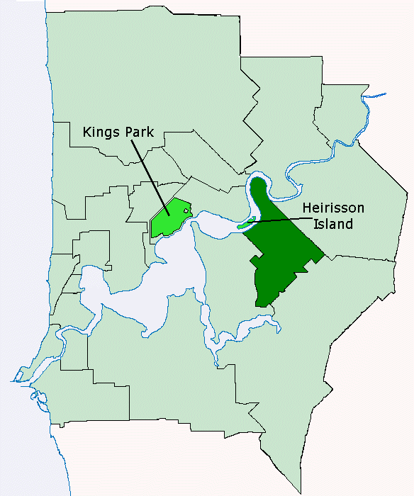
bridge engineering project in or about Perth, and involved augmenting the Heirisson mudflats into a proper island. The mudflats were at that time an important resource for theNoongar Indigenous Australians . The current bridge is the "third edition":: Originally opened in 1843;: Largely rebuilt after disastrous floods in 1862, reopened in 1867;: Improved several times in 1899, 1903, 1933 and 1943;: Completely rebuilt from 1947 and reopened in 1952.
Lathlain Park is the home of the (WAFL)
Perth Football Club .Victoria Park is also a locality within this
municipality .uburbs
* Burswood
* Carlisle
* East Victoria Park
* Lathlain
* Victoria Park
* St James (Shared with City of Canning)
* Welshpool (Shared with City of Canning)
* Bentley (Shared with City of Canning)
* Kensington (Shared with City of South Perth)
* Rivervale (Shared with City of Belmont)References
External links
* [http://www.vicpark.ws Town of Victoria Park website]
* [http://maps.google.ru/maps/ms?msa=0&msid=110879795975122207285.000445a252715c198058b Town of Victoria Bark Suburbs On Google Maps]
Wikimedia Foundation. 2010.