- Shire of Derby-West Kimberley
-
Shire of Derby-West Kimberley
Western Australia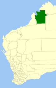
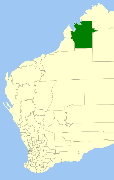
Population: 7,940(2009)[1] Area: 104080 km² (40,185.5 sq mi) Mayor: Elsia Archer Council Seat: Derby Region: Kimberley State District: Kimberley Federal Division: Durack LGAs around Shire of Derby-West Kimberley: Cocos Wyndham-East Kimberley Wyndham-East Kimberley Broome Shire of Derby-West Kimberley Halls Creek Broome East Pilbara Halls Creek The Shire of Derby-West Kimberley is one of the four Local Government Area in the Kimberley Region of northern Western Australia, covering an area of 104,080 square kilometres (40,186 sq mi), most of which is sparsely populated. The shire's estimated population in 2009 was 7,940, with most residing in the major towns of Derby, which is also the Shire's seat of government, and Fitzroy Crossing. There are also around 70 Aboriginal communities located around the shire.
The major industries of the shire include sheep and cattle for export, fishing, and tourism.
Contents
History
The Shire of Derby-West Kimberley originated as the West Kimberley Road Board in 1884. Changes in the Local Government Act in 1961 altered the name to the Shire of West Kimberley. The current name was adopted in 1983.
Wards
All nine councillors represent the whole of the Shire.
Towns
- Cockatoo Island
- Camballin
- Derby
- Looma
- Fitzroy Crossing
- Noonkanbah (Yungngora Community)
References
- ^ Australian Bureau of Statistics (30 March 2010). "Regional Population Growth, Australia, 2008–09". http://www.abs.gov.au/ausstats/abs@.nsf/Latestproducts/3218.0Main%20Features82008-09?opendocument&tabname=Summary&prodno=3218.0&issue=2008-09&num=&view=. Retrieved 4 June 2010.
External links
- Shire of Derby-West Kimberley
- Map of Aboriginal Communities in West KimberleyPDF (211 KB). Department of Indigenous Affairs (DIA).
Coordinates: 17°23′S 123°41′E / 17.39°S 123.68°E
Wikimedia Foundation. 2010.