- City of Nedlands
-
This article is about a local government area. For the suburb, see Nedlands, Western Australia.
City of Nedlands
Western Australia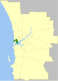
Population: 22,508(2010)[1] Established: 1893 Area: 20 km² (7.7 sq mi) Mayor: Sheryl Froese Council Seat: Nedlands Region: West Metropolitan Perth State District: Nedlands Federal Division: Curtin 
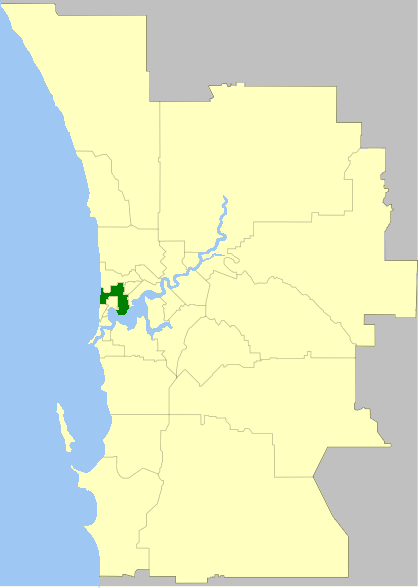
LGAs around City of Nedlands: Indian Ocean Cambridge Cambridge Indian Ocean City of Nedlands Subiaco Cottesloe Claremont Subiaco The City of Nedlands is a Local Government Area in the inner western suburbs of the Western Australian capital city of Perth, located about 7 kilometres (4 mi) west of Perth's central business district. The City covers an area of 20.0 square kilometres (7.7 sq mi), maintains 137 km of roads and a little over 380 hectares (939 acres) of parks and gardens, and has a population of over 22,000 (2008).
Contents
History
The City of Nedlands had its origins in the Claremont Road District, which was created in 1893 after a petition from ratepayers who lived in the areas of Nedlands and Claremont, which had grown substantially in population at the end of the 19th century. Seven men were nominated to the new Board, which became the first local government authority for the Nedlands/Claremont area. In 1898, Claremont itself split away to form a municipal government, which still exists today as the Town of Claremont.
In 1932, the Claremont Road Board was renamed Nedlands, and on 1 July 1959, it became a City. The City was made up of four wards – Melvista, Hollywood, Dalkeith and Coastal. These wards continue to the present day.
Wards
The town has been divided into 4 wards, each of 3 councillors. The mayor is directly elected.
- Coastal Ward
- Dalkeith Ward
- Hollywood Ward
- Melvista Ward
Suburbs
* Shared with other council areas (Subiaco; Cambridge)
Population
Year Population 1911 1,230 1921 3,557 1933 10,580 1947 18,226 1954 22,814 1961 23,218 1966 23,320 1971 22,878 1976 20,974 1981 20,257 1986 18,623 1991 20,210 1996 20,598 2001 21,047 2006 20,334 See also
- AmpFest, Youth and music festival overseen by the City of Nedlands
References
- ^ Australian Bureau of Statistics (31 March 2011). "Regional Population Growth, Australia, 2009–10 - Western Australia". http://www.abs.gov.au/ausstats/abs@.nsf/Products/3218.0~2009-10~Main+Features~Western+Australia?OpenDocument. Retrieved 10 May 2010.
External links
Western suburbs of Perth, Western Australia City Beach · Claremont · Cottesloe · Crawley · Daglish · Dalkeith · Floreat · Jolimont · Karrakatta · Mosman Park · Mount Claremont · Nedlands · Peppermint Grove · Shenton Park · Subiaco · Swanbourne · Wembley · Wembley Downs · West Leederville
Cities of Western Australia Capital city Metropolitan cities Regional cities Large towns Categories:- Populated places established in 1893
- 1893 establishments in Australia
- Local Government Areas of Western Australia
Wikimedia Foundation. 2010.