Yanchep, Western Australia
- Yanchep, Western Australia
Infobox Australian Place | type = suburb
name = Yanchep
city = Perth
state = wa
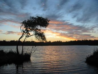
caption = Sunset over Loch McNess in Yanchep National Park
lga = City of Wanneroo
postcode = 6035
est = 1970
pop = 2,482 (2006 census)
area = 221.4
propval =
stategov = Mindarie
fedgov = Pearce
near-nw =
near-n = Two Rocks
near-ne =
near-w = "Indian Ocean"
near-e = Pinjar
near-sw =
near-s = Eglinton
near-se = Carabooda
dist1 = 56
location1= Perthcoord|-31.5506|115.634|type:city(2482)_region:AU-WA_scale:50000|format=dms|display=title
Yanchep is an outer northern suburb of Perth, the capital city of Western Australia. It was built by entrepreneur Alan Bond. It is a suburb of the City of Wanneroo. Yanchep is a popular tourist destination. There is beachside accommodation and popular caravan sites and there is also the Yanchep Inn in the National Park.
Yanchep National Park includes guided tours of Crystal Cave, bush walks, koala displays, and the Loch McNess lake. During the 1980s the area was home to popular tourist attractions including Atlantis Marine Park and the Sun City Marina.
The suburb contains a district high school, offering education from kindergarten to Year 10.
The first family to live in Yanchep were Maureen and Roy Saville, who had there house transported on a truck.
External links
Wikimedia Foundation.
2010.
Look at other dictionaries:
Western Australia — Coordinates: 26°0′S 121°0′E / 26°S 121°E / 26; 121 … Wikipedia
Western Australia — Australie Occidentale Western Australia (Australie Occidentale) … Wikipédia en Français
Neerabup, Western Australia — Neerabup Perth, Western Australia Agricultural land on Wattle Avenue … Wikipedia
Mindarie, Western Australia — Coordinates: 31°41′17″S 115°42′25″E / 31.688°S 115.707°E / 31.688; 115.707 … Wikipedia
Clarkson, Western Australia — Coordinates: 31°41′02″S 115°43′41″E / 31.684°S 115.728°E / 31.684; 115.728 … Wikipedia
Eglinton, Western Australia — Infobox Australian Place | type = suburb name = Eglinton city = Perth state = wa caption = Looking southeast from future Marmion Avenue just north of Pipidinny Road lga = City of Wanneroo area = 10 pop = 67 postcode= 6034 dist1 = 44 |… … Wikipedia
Perth, Western Australia — Perth, Australia redirects here. For the town in Tasmania, see Perth, Tasmania. For other uses, see Perth (disambiguation) and Perth, Western Australia (disambiguation). Perth Western Australia … Wikipedia
Hamersley, Western Australia — Infobox Australian Place | type = suburb name = Hamersley city = Perth state = wa caption = View east from Benjafield Way towards ABC tower lga = City of Stirling area = 3.267 postcode= 6022 pop = 4,965 (2006 census) dist1 = 14 | dir1 = NNW |… … Wikipedia
Carabooda, Western Australia — Infobox Australian Place | type = suburb name = Carabooda city = Perth state = wa caption = View from Wanneroo/Karoborup Roads. lga = City of Wanneroo area = 19.1 pop = 377 (2001 census) postcode = 6033 dist1 = 45 location1= Perth fedgov = Pearce … Wikipedia
Jindalee, Western Australia — Infobox Australian Place | type = suburb name=Jindalee city=Perth state=wa caption=Park on Jindalee Boulevard. lga=City of Wanneroo area=3 postcode=6036 dist1=40 location1=Perth fedgov=Pearce stategov=Mindarie near nw= near n=Alkimos near ne=… … Wikipedia