- Burns Beach, Western Australia
Infobox Australian Place | type = suburb
name = Burns Beach
city = Perth
state = wa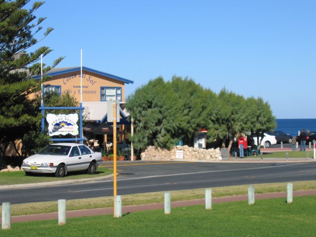
caption = Costa Del Sol Cafe and Restaurant and the Indian Ocean at Burns Beach.
lga = City of Joondalup
area = 3.3
postcode = 6028
pop = 225 (2006 census)
dist1 = 34
location1= Perth
est = 1920s
fedgov = Moore
stategov = Ocean Reef
propval =
near-nw =
near-n = Tamala Park
near-ne =
near-w = "Indian Ocean "
near-e = Kinross
near-sw =
near-s = Iluka
near-se = Currambinecoord|-31.719|115.724|type:city(225)_region:AU-WA_scale:30000|format=dms|display=titleBurns Beach is a suburb of Perth,
Western Australia , located convert|34|km|mi|0 north of Perth'scentral business district at the northern fringe of theCity of Joondalup . Burns Beach has managed to maintain much of its original character as a small coastal village even with its loss of isolation, and the beach is popular amonghang gliding enthusiasts. [cite web|url=http://www.hgfa.asn.au/~hgawa/sites/perth/perth.html#bb|title=Perth Region Sites Guide|date=12 April 2006|author=Hang Gliding Association of WA|accessdate=2006-10-27]History
The land at Burns Beach was originally owned by the
Midland Railway Company . In 1908, following a request from 50 local residents, the Wanneroo Road Board (which eventually became Wanneroo City Council) successfully applied for a convert|20|ha|acre|0|sing=on reserve for camping and a health resort. By the 1920s, the area was well used by locals who knew the area as "Burns Beach" after a farmer who ran sheep in the area. [LandInfo WA|m|B|2007-05-15]For many years it was accessible only by track or boat and functioned as a small coastal village, and tourism and fishing were the main occupations. After the
Second World War , it was connected by road toWanneroo Road .The sprawl of housing development extending northwards from Perth reached Burns Beach in the early-to-mid 1990s with the growth of Joondalup as a regional centre and the construction of the suburbs of Currambine and Kinross.
Present day
Burns Beach has managed to maintain much of its original character even with its loss of isolation, and the original caravan park is still in operation. Burns Beach marks one end of a coastal nature walk extending to Fremantle. The suburb also contains a cafe and restaurant (Costa del Sol) with outdoor seating, as well as a picnic area with barbecues and toilets.
A new estate, Peet Limited's [http://burnsbeachestate.com.au Burns Beach Estate] , is presently being built north of Burns Beach Road. In early 2006 clearing and road widening were undertaken to facilitate the construction. A community centre and school is expected to be built as part of the development.
Geography
Burns Beach is bounded by the ocean to the west,
Marmion Avenue to the east and Burns Beach Road to the south.Streetsmart WA|maps=Map 219] A bushland buffer to the north separates Burns Beach and Kinross from the Mindarie-Clarkson urban region.At the ABS 2001 census, Burns Beach had a population of 225 people living in 90 dwellings, with a median age of 39 years (among the oldest in the northern suburbs). A caravan park at the end of Ocean Parade (technically in Iluka) houses another 90 residents.Census 2006 AUS|id=SSC51211|name=Burns Beach (State Suburb)|accessdate=2007-08-03] Residential styles in Burns Beach include a mix of holiday dwellings from before and after World War II.
Education
The nearest primary schools are at Beaumaris (Ocean Reef), Currambine and Kinross. Burns Beach falls within the Ocean Reef Senior High School and Clarkson Community High School catchment areas.
Transport
Burns Beach is served by the 470 and 471
Transperth bus routes from Joondalup, [ [http://www.transperth.wa.gov.au/timetablePDFs/Northern%2067%2020070429.pdf Northern 67 timetable] , Transperth, effective 29 April 2007. Accessed 3 August 2007.] operated byPath Transit .Politics
Burns Beach is a reasonably affluent suburb with a large elderly population. While this would normally point to a clear Liberal Party preference, fishermen and permanent residents of the caravan park who favour Labor comprise a fair proportion of those voting at Burns, making it a marginal booth with no clear preference at either federal or state elections. Nearby Kinross, an urban residential estate suburb similar to the proposed Burns Beach Estate, favours the Liberal Party although not as strongly as Currambine and Ocean Reef to the south.
References
Wikimedia Foundation. 2010.