- Ely, Cambridgeshire
-
Coordinates: 52°24′N 0°16′E / 52.40°N 0.26°E
City of Ely 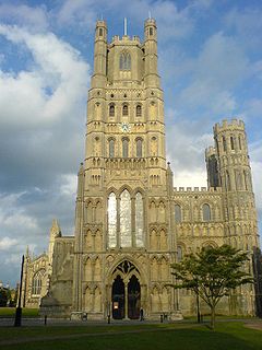
Ely Cathedral whose octagon is one of the wonders of the medieval world[1]
 City of Ely
City of Ely shown within CambridgeshireArea 23 sq mi (60 km2) [2] Population 15,102 (2001 Census) - Density 657 /sq mi (254 /km2) OS grid reference TL535799 Parish Ely District East Cambridgeshire Shire county Cambridgeshire Region East Country England Sovereign state United Kingdom Post town ELY Postcode district CB6, CB7 Dialling code 01353 Police Cambridgeshire Fire Cambridgeshire Ambulance East of England EU Parliament East of England UK Parliament South East Cambridgeshire Website ECDC List of places: UK • England • Cambridgeshire Ely (
 i/ˈiːli/ ee-lee) is a cathedral city in Cambridgeshire, England. It is located 14 miles (23 km) north-northeast of Cambridge and about 80 miles (129 km) by road from London.
Ely was for a long time informally considered to be a city by virtue of being the seat of a diocese. In 1974 the status was confirmed by royal charter on the parish council of the successor parish to Ely Urban District.
Contents
History
Roswell Pits[i] are a palaeontologically significant Site of Special Scientific Interest (SSSI) 1 mile (1.6 km) north-east of the city. The Jurassic Kimmeridge Clays were mined in the nineteenth and twentieth centuries for the maintenance of river embankments. During this process many specimens of ammonites, belemnites and bivalves were found including most of a Pliosaurus.[5]
The name Ely comes from Old English Ēl-gē meaning "eel region", from the eels abundant in the marshes around; Elge 731,Elyg 1086 (Domesday Book).[6][7]
The city's origins lay in the foundation of an abbey in AD 673,[8][9] a mile (1.6 km) to the north of the village of Cratendune on the Isle of Ely, under the protection of St Ethelreda, daughter of King Anna. The abbey was destroyed in 870 by Danish invaders[10] and not rebuilt for over a hundred years. The city took part in the Peasants' Revoltof 1381.[11]
Oliver Cromwell lived in Ely for several years after inheriting the position of local tax collector in 1636.[12] His former home dates to the sixteenth century[13] and is now used by the Tourist Information Office, as well as being a museum with rooms displayed as they would have been in Cromwell's time. Cromwell was one of the Governors of the Thomas Parson's Charity,[14] which dates back to the fifteenth century (1445) and was granted a Royal Charter by Charles I. The Original Charter and copies of the Minute Book containing Oliver Cromwell's handwriting and signature have been loaned to the Ely Museum. The Charity still provides Grants and Housing to deserving local applicants.
Fairs have been held in Ely since the twelfth-century.[15] St Audrey's (Etheldreda's) seven-day fair, held either side of the 23 June, was first granted officially by Henry I to the abbot and convent on 10 October 1189.[16] At this fair, cheap necklaces, made from brightly coloured silk, were sold. These were called tawdry lace.[17] Tawdry, a shortened form of Audrey, now means cheap and gaudy jewellery.[18]
There was a kind of workhouse in 1687, perhaps at St Mary's, which may have been part of the arrangement made between the Ely people and a Norwich man in 1675. He was paid £30 per annum to employ the poor to 'spin jersey' and was to pay them in money not goods.[19] A purpose-built workhouse was erected in 1725 for 35 inmates on what is now St Mary's Court. Four other workhouses existed: 1738–1956 Holy Trinity on Fore Hill for 80 inmates, 1837– Ely Union which became Tower Hospital and is now the residential Tower Court, The Haven Quayside for unmarried mothers and finally the site of what is now the Hereward Hall in Silver Street.[20]
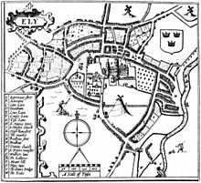 John Speed's plan of Ely, 1610.[ii] He names the cathedral St Peter's and he shows a windmill on Mount Hill. Since Bentham's time, Mount Hill has been called Cherry Hill
The diaries of writers such as William Camden, Celia Fiennes, Daniel Defoe, John Byng and William Cobbett show a picture of the decline of Ely and its cathedral following the fourteenth-century plague and sixteenth-century reformation which in turn led to the dissolution of the abbey in 1539.[23] In Britannia of 1607, translated from the original Latin by Philemon Holland, Camden reports that "As for Ely it selfe, it is no small Citie, or greatly to be counted off either for beauty or frequency and resort, as having an unwholsome aire by reason of the fens round about, ...".[24] In 1698, Fiennes was writing "The Bishop does not Care to stay long in this place not being for his health; ... They have lost their Charter ... and its a shame [the Bishop] does not see it better ordered and ye buildings and streetes put in a better Condition. They are a slothful people and for little but ye takeing Care of their Grounds and Cattle wch is of vast advantage".[25] Defoe, writing in the Eastern Counties section of A tour thro' the whole island of Great Britain in 1722, went "... to Ely, whose cathedral, standing in a level flat country, is seen far and wide; ... that some of it is so antient, totters so much with every gust of wind, looks so like a decay, and seems so near it, that when ever it does fall, all that 'tis likely will be thought strange in it, will be, that it did not fall a hundred years sooner".[26] On his way to a Midlands tour, Byng visited Ely on the 5 July 1790. In his diary[iii] he writes that "The town [Ely] is mean, to the extreme; ... those withdrawn, their dependancies must decay; ...".[27] Recording in his Rural Rides on 25 March 1830, Cobbett informs us that "Ely is what one may call a miserable little town: very prettily situated, but poor and mean. Everything seems to be on the decline, as, indeed, is the case everywhere, where the clergy are the masters".[28]
The Ely and Littleport riots 1816 occurred between 22 and 24 May 1816 at Littleport and Ely. At the Special Commission assizes, held at Ely between 17 and 22 June 1816, twenty-four rioters were condemned. Nineteen had their sentences variously commuted from penal transportation for life to twelve-months imprisonment. Five of the twenty-four were executed on 28 June 1816.[29]
Ely Cathedral was the first great cathedral to be fully restored. Work commenced in 1845 and completed nearly thirty years later; most of the work was, according to Dorman, sympathetically carried out by the architect George Gilbert Scott.[30] The only pavement labyrinth to be installed in an English cathedral was installed below Ely's west tower in 1870.[31][32]
Historical documents relating to Ely, including Church of England parish registers, court records, maps and photographs, are held by Cambridgeshire Archives and Local Studies at the County Record Office in Cambridge.
Modern times
For over 800 years the cathedral—built on an elevation of 68 feet (21 m) above the nearby fenland—and its associated buildings, visually influenced the city and its surrounding area. They still do. Jones writing in 1924 reports that "... from the roof of King's Chapel in Cambridge, on a clear day, Ely [cathedral] can be seen on the horizon, 16 miles (26 km) distant, an expression of the flatness of the fens".[33] In 1954, Pevsner wrote "... as one approaches Ely on foot or on a bicycle, or perhaps in an open car, the cathedral dominates the picture for miles around". He continues "... and offers from everywhere an outline different from that of any other English cathedral".[34] Blakeman reports a claim that "Grouped around [the cathedral] ... is the largest collection of mediaeval [sic] buildings still in daily use in this country".[35]
As the seat of a diocese with a cathedral, Ely has long been considered a city: the caption underneath John Speed's 1610 plan of Ely[36] reads "Although this Citie of Ely ..." and Aikin refers to Ely as a city in 1800.[37] The town of Ely, however, was not formally granted city status until 1 April 1974 by the Queen using letters patent. In the same announcement and by the same means, other English settlements were made cities such as the Parish of Wells and the Borough of York.[38] Ely's population of 15,102 makes it the second smallest city in England, excluding the City of London.[39][40]
Henry III of England formally granted a market to the Bishop of Ely using letters close on 9 April 1224[41] although Ely has been a trading centre prior to this.[42] Present market day is Thursday and Saturday each week. The city is on the River Great Ouse and was a significant port until the eighteenth century, when the Fens were drained and Ely ceased to be an island. The river is a popular boating area with a large marina.
Geography
See also: The Fens
Little Downham Chettisham Queen Adelaide Witcham 
Prickwillow  Ely
Ely 

Witchford Little Thetford River Great Ouse
StuntneyGeology and topography
West Cambridgeshire is made up of middle Mesozoic Era rocks (limestones) from the Jurassic system whilst East Cambridgeshire consists of the upper Mesozoic Era rocks (chalks known locally as clunch[43]) from the Cretaceous system. In between these two major formations, the high ground forming the Isle of Ely is from a lower division Cretaceous system known as Lower Greensand which is capped by Boulder Clay; all local settlements are on similar islands such as Stretham and Littleport. These islands rise above the surrounding flat tracts of land, the largest plain of Britain,[iv] from the Jurassic system of partly consolidated clays or muds.[10] Kimmeridge Clay beds dipping gently west occur under the Lower Greensand of the area, exposed for example about 1 mile (1.6 km) south of Ely in the Roswell Pits.[45] The Lower Greensand is partly capped by glacial deposits which form the highest point in East Cambridgeshire rising to 85 feet (26 m) above sea-level in Ely.[46]
The low-lying Fenland surrounding the island of Ely, prior to the seventeenth century, was formed by alternate fresh-water and sea-water incursions. Major rivers in the region, including the Witham, Welland, Nene and Great Ouse drain 6,000 square miles (16,000 km2) of surrounding uplands into the basin forming the Fenland; an upland area five times larger than the Fenland itself.[47] Defoe in 1774 described the Fenland as "... the sink of no less than thirteen Counties ...".[48] On 23 November of the same year, John Wesley, wrote of his approach to Ely after visiting Norwich "... About eight, Wednesday, 23, Mr. Dancer met me with a chaise and carried me to Ely. Oh, what want of common sense! Water covered the high road for a mile and a half. I asked, 'How must foot-people come to the town?' 'Why, they must wade throughl'".[49] Peat formed in the fresh-water swamps and meres whilst silts were deposited by the slow-moving sea-water.[50] During the seventeenth century, the Earl of Bedford, supported by Parliament, financed the draining of the fens which was led by the Dutch engineer Cornelius Vermuyden, which continue to this day.[51]
Climate
With an average annual rainfall of 24 inches (600 mm), Cambridgeshire is one of the driest counties in the British Isles. Protected from the cool onshore coastal breezes east of the region, Cambridgeshire is warm in summer and cold and frosty in winter.[52] Regional weather forecasting and historical summaries are available from the UK Met Office.[53][54] The nearest Met Office weather station is Cambridge NIAB. Additional local weather stations report periodic figures to the internet such as Weather Underground, Inc.[55]
Climate data for Cambridge Month Jan Feb Mar Apr May Jun Jul Aug Sep Oct Nov Dec Year Average high °C (°F) 7.0
(44.6)7.4
(45.3)10.2
(50.4)12.6
(54.7)16.5
(61.7)19.4
(66.9)22.2
(72.0)22.3
(72.1)18.9
(66.0)14.6
(58.3)9.9
(49.8)7.8
(46.0)14.1 Average low °C (°F) 1.3
(34.3)1.1
(34.0)2.9
(37.2)4.0
(39.2)6.7
(44.1)9.8
(49.6)12.0
(53.6)11.9
(53.4)10.1
(50.2)7.1
(44.8)3.7
(38.7)2.3
(36.1)6.1 Rainfall mm (inches) 45.0
(1.772)32.7
(1.287)41.5
(1.634)43.1
(1.697)44.5
(1.752)53.8
(2.118)38.2
(1.504)48.8
(1.921)51.0
(2.008)53.8
(2.118)51.1
(2.012)50.0
(1.969)553.5
(21.791)Source: Met Office Demography
Historical population of Ely Year 1801 1811 1821 1831 1841 1851 1861 1871 1881 1891 1901 Population 3,948 4,249 5,079 6,189 6,849 7,632 7,982 8,166 8,171 8,017 7,803 Year 1911 1921 1931 1941 1951 1961 1971 1981 1991 2001 2011 Population 7,917 7,690 8,381 [v] 9,988 9,803 9,966 10,392 11,291 15,102 – Census: 1801–2001[2]
Economy
Fishing (see Domesday), fowling (see Defoe), cattle, sheep, coprolite, clay, drainage, farming, sugar beet, peat farming Animal husbandry; "... grain as a fodder crop and for household use ...";[56] "... reclaimed land used for pasture for horses and sheep ..."; "... fishing and fowling in winter ..."; "... thriving local trade in wares made from reeds, osiers and rushes ..."[57]
Gallois (1988) "The district is almost entirely agricultural and has always been so. The only mineral worked at the present time is gravel for aggregate. although chalk, brick clay (Ampthill and Kimmeridge clays), phosphate (from Woburn Sands, Gault and Cambridge Greensand), sand and gravel, and peat have been worked on a small scale in the past".[58]Ely had a long association with pottery production, commencing in the twelfth century and lasting until 1860.[59] Around eighty persons who classed their trade as potters have been identified in the records.[60] Babylon-ware is the name given to pottery made in Ely. Thought to be so named because there were potters in an area of the city cut-off from the main city by the re-routing of the River Great Ouse at an unknown time between late Saxon and early the medieval time. The building of the Ely to Lynn railway in 1847 cut this area off even further.[61][62]
Governance
Local
Ely is governed by Cambridgeshire County Council for which the city returns two councillors, both of whom are currently Liberal Democrats.[63] Before 1974 the city was administered by Cambridgeshire and Isle of Ely County Council, which merged with Huntingdon and Peterborough following the Local Government Act 1972.[64] From 1889 to 1964 the Isle of Ely County Council covered the city and its surrounds.
Since 1974 Ely has been part of East Cambridgeshire Non-metropolitan district and is the seat of the council.[65] The city is divided into four wards - Ely South, Ely East and Ely West (all returning 2 district Councillors each) and Ely North (returning 3)[66] - The seats are currently held by four Liberal Democrats and five Conservative.[67]
Westminster
Ely was part of the three-seat constituency of Cambridgeshire until 1885, when major boundary changes occurred nationwide; Cambridgeshire constituency was split into single-member constituencies. The town of Ely was placed within the new Newmarket constituency; the church interest, as well as the middle-class character of the area, contributed to Tory political strength in the constituency, which as a whole was a Tory-Liberal marginal.[citation needed]
Boundary changes in 1918 saw the town of Ely merged with the old Wisbech constituency to create a new constituency of Isle of Ely.[68] This seat was also a Tory-Liberal marginal until 1945, when the Tories won even in the wake of the national Labour landslide, and the Liberals finished in third place in the constituency for the first time ever. Clement Freud gained the seat for the Liberals at a by-election in 1973.[69]
In 1983 Ely was transferred to the newly created constituency of South East Cambridgeshire,[70] where it has remained since. Freud did not run in the constituency, contesting instead another new seat, North East Cambridgeshire (where he was defeated by the Conservatives), and the first member for the new South East Cambridgeshire was the former Conservative Foreign Secretary Francis Pym.[71] James Paice has held the seat since 1987;[72] he was appointed Minister of State for Agriculture and Food in the Coalition Government on 13 May 2010.[73]
Culture
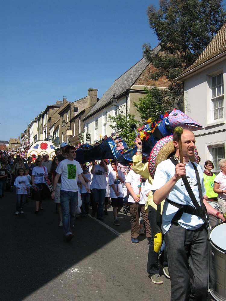
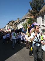 Eel day carnival procession down Fore Hill
2007Annual events
Annual events in Ely include the Aquafest, which has been staged by the Rotary Club on the first Sunday of each July since 1978. Held at the riverside in Ely, the 2011 Ely Aquafest was the festival's 33rd year.[74] Other events include the Eel Day carnival procession[75] and the annual fireworks display in Ely Park, first staged in 1974.[76] The Ely Folk Festival has been held in the city since 1985[77] and in 2011 it celebrated its 26th year. The Ely Horticultural Society have been staging their Great Autumn Show in the city for 84 years.[78]
Twin town
Landmarks
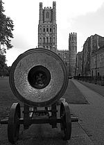 This cannon was captured during the Crimean War at the Siege of Sevastopol (1854–1855)[81] and was presented to the people of Ely by Queen Victoria in 1860. It is located on the Palace Green west of Ely Cathedral and north west of the Bishop's Palace[82]
War memorial
The cannon on the Palace Green west of the cathedral was captured during the Crimean War at the Siege of Sevastopol (1854–1855).[81] The inscription reads "Russian cannon captured during the Crimean War presented to the people of Ely by Queen Victoria in 1860 to mark the creation of the Ely Rifle Volunteers".[82]
Notable buildings
See also: Listed buildings in Ely and Ely CathedralThere are twenty three Grade I, six Grade II* and one hundred and fifty three Grade II listed buildings[83] in the city of Ely.[84]
Cherry Hill, on the south of the cathedral park, is the remains of the Norman period motte-and-bailey Ely Castle.[85] The earliest record of this 40-foot (12 m) high by 250 feet (76 m) diameter castle is in the time of Henry I.[86] Two twelfth-century hospitals, St Mary Magdalene founded 1172 and St John the Baptist founded circa 1200, were on the site of what is now a four building farmstead. Building dates are not known but the extant remains indicate circa 1175–85.[87] Bishop Northwold joined the two hospitals in 1240. For example, the farmsteads Grade I listed building status was split when graded into St John's Farmhouse,[88] a barn to the south-west (formerly chapel of St John),[89] a barn to the north (formerly chapel of St Mary)[90] and a dovecote.[91] Above the north doorway of the south-western barn of St John's farmhouse is a carved Barnack stone which is built into the thirteenth-century wall. The stone is thought to have originally come from the Anglo-Saxon monastery of St Ethelreda.[vi] This heavily weathered eighth-century stone shows a man blowing a horn whilst riding on an ox.[93][94]
St Mary's Vicarage, known more locally as Cromwell House, is of mainly sixteenth-century plaster-frame construction although there exists some circa 1380 stone arches. A plaque on the front of the house records that this is "... Cromwell House, the residence of Oliver Cromwell from 1636-1647 when collector of Ely Tithes".[95] Its main contemporary use is as a re-creation of seventeenth century living and the Ely tourist information centre.[96]
The city's courthouse was built in 1821, replacing a previous court in the Shire Hall.[97] It was closed in 2011 as part of central government measures to shut down 93 Magistrates' Courts across England and Wales.[98]
Notable sites
Further information: Roswell PitsThe former Kimmeridge Clay quarry Roslyn or Roswell Pits, 1 mile (1.6 km) south-west of Ely Cathedral, are now a nature reserve and Site of Special Scientific Interest (SSSI).[99] The trees in Abbey Park were planted on Mount Hill in 1779 by James Bentham, a minor canon of Ely. Ely Castle once stood on Mount Hill which was renamed Cherry Hill following the tree plantings by Bentham.[100][101][102] The Chettisham Meadow SSSI is a medieval ridge and furrow neutral grassland about 0.6 miles (1 km) north of the city centre.[103] This site, one of the UK's best remaining examples of ridge and furrow agriculture, also contains protected species such as the Anacamptis morio (Green-winged Orchid).[104]
Transport
Buses
Further information: List of bus routes in ElyRail
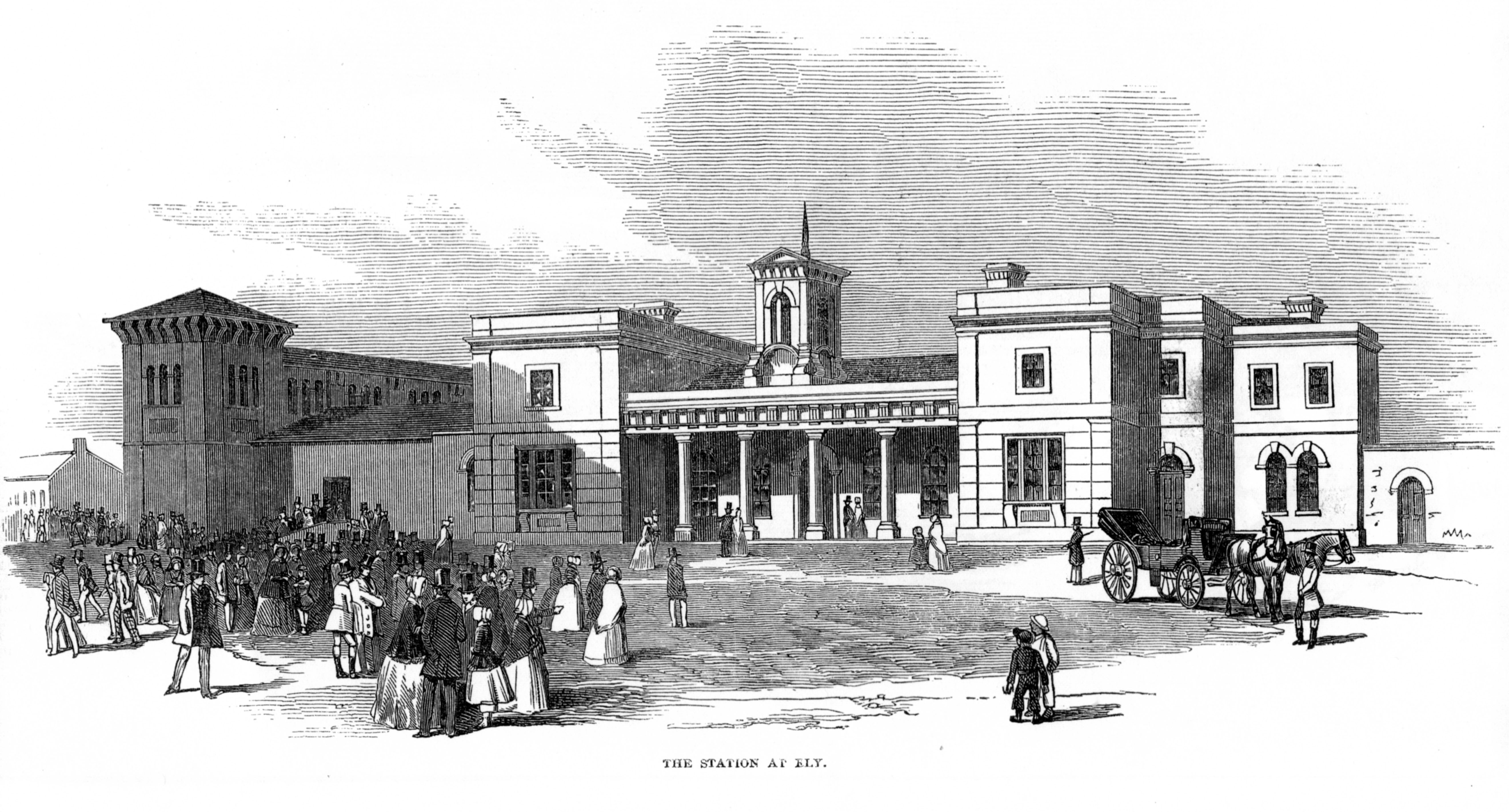
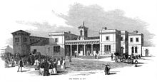 Engraving[vii] from The Illustrated London News of the station at Ely during the opening on 25 October 1847 of the Lynn and Ely railway, now part of the Fen Line[105]Main article: Railways in Ely
Ely railway station, on the Fen Line, is a major railway hub with the Cambridge to Ely section opening in 1845. Five major railway lines—excluding the former Ely and St Ives Railway—emanate from this hub: north to King's Lynn, north-west to Peterborough, east to Norwich, south-east to Ipswich and south to Cambridge then London.[106] At the opening of the 26.5-mile (42.6 km) Lynn and Ely railway "... with great éclat"[105] on 25 October 1847, Ely station, built in 1847,[107] was described by The Illustrated London News as "... an extensive pile[viii] in pleasing mixed Grecian and Italian style".[105] The former Ely and St Ives Railway, known locally as the Grunty Fen express,[108] opened in 1865 and was never popular. In 1866, the 7.5 miles (12.1 km) return journey from Ely to Sutton cost 2s 0d.[109] That equates to a cost of almost £7 at present worth,[110] as of 2011.[111] The line closed to passengers in February 1931 and completely closed in 1964.[112] There are now, in 2011, direct trains to Cambridge, London, most of East Anglia, the Midlands and the North. There are connecting services to many other parts of England and to Scotland. As of 2010, the operating companies were: First Capital Connect, National Express East Anglia, Crosscountry and East Midlands Trains.
Road
A Roman road, named Akeman Street,[ix] is documented from Ermine Street near Wimpole through Cambridge, Stretham and Ely to Brancaster through Denver.[114] This is not the same road as the major Roman road named Akeman Street which started from Verulamium (south-west of St Albans) then via Tring and Aylesbury terminating near Alcester.[115] In John Fordham's survey of Ely in 1416–1417, an east to west Akermanstrete or Agemanstrete is mentioned, which Stewart says now forms part of the east-west Egremont Street.[116] Babington believes that this east-west Ely street is not the Roman road Akeman Street, which should pass through Ely west of the cathedral in a north-south direction.[117] Gray and Stubbings contend that the Wimpole to Brancaster road name of "Akeman was derived by antiquarians, without justification, from Acemanes-ceastre, an ancient name for Bath".[118]
In the 1760's, James Bentham encouraged the ecclesiastical authorities and the townspeople of Ely to build, by subscription, a turnpike road between Ely and Cambridge the building of which started in 1769.[119] The eighteenth century London to King's Lynn coach route, documented by the surveyor John Cary, passed through Ely with a coach stop at the Lamb Inn, a coaching-inn in 1753[120] and still extant as The Lamb.[121] Cary measured the distance from London (Shoreditch) to Ely section as being 67 miles (108 km).[122] Ely is on the route of the north-south A10 trunk road from London to King's Lynn; the Bypass of the town centre was built in 1986.[123] The east-west A142 road from Newmarket to Chatteris passes through the south of the town.
A proposal for an Ely southern bypass of the A142 is included in the major schemes of the Cambridgeshire Local Transport Plan. The proposed route would be a single, two lane carriageway and would include 1.2 miles (1.9 km) of new road construction between new roundabout junctions on Stuntney Causeway and Angel Drove. The bypass is intended to reduce congestion in Ely, and to avoid the low bridge on the Ely to Kings Lynn railway line, which has the third highest vehicle strike rate in the country. Proposals for the bypass went to public consultation in October 2011 and the County Council and District Council have announced that they hope to fund some of the costs of the bypass, estimated to be up to £28 million,[124] with contributions from developers who are hoping to build a retail park near to the proposed route.[125][126]
Religious sites
- Ely Cathedral
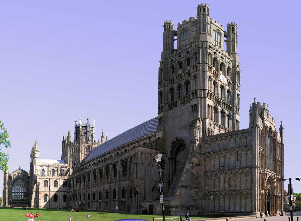
Main article: Ely CathedralFurther information: Diocese of ElyThe Cathedral Church of the Holy and Undivided Trinity is known as the "Ship of the Fens",[127][128] a name inspired by the distant views of its towers, which dominate the low-lying wetlands known as The Fens.[34] The diocese of Ely was created in 1108 out of the see of Lincoln, and a year later the bishopric of Ely was founded. The cathedral was started by William I in 1083, finally opening in 1189 after 116 years of planning.[129] On 12–13 February 1322 it suffered the collapse of the main tower, which was rebuilt as an octagon.[130] The cathedral was completed in 1351. John Wesley, writing of his 22 November 1774 visit to Ely, thought that " ... the cathedral, [is] one of the most beautiful I have seen. The western tower is exceedingly grand, and the nave of an amazing height".[49]
Ely is the nearest cathedral city to Cambridge, which lies within the same diocese but does not have its own cathedral. The Diocese of Ely covers 1,507 square miles (3,903 km2) and holds 641,000 people (2011) and 335 churches. It includes most of the county of Cambridgeshire except for most of Peterborough, which has its own diocese and three parishes in the south which are in the diocese of Chelmsford. The Diocese of Ely also includes the western part of Norfolk, a few parishes in Peterborough and Essex, and one in Bedfordshire.[131]
- Other
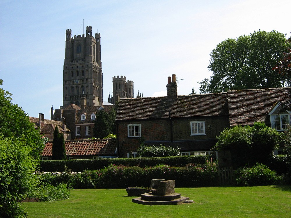
 View from St Mary's churchyard
The church of St Mary, dedicated by Bishop Eustace,[132] is an early thirteenth-century building with a circa 1300 spire and tower with eight bells. The church was heavily restored starting in 1877.[133] The St Etheldreda Roman Catholic Church in Egremont Street dates from 1891.[134] The methodist chapel building, in Chapel Street, was built in 1818 and was restored in 1891.[135] The Salem Baptists chapel was erected in 1840.[134] The Church of St Peter on Broad Street was built in 1890. The architect was James Piers St Aubyn.[136]
Sport
See also: Fen skatingEly City F.C. is a football club that was established in 1885 and joined the Eastern Counties Football League in 1960. In the 1997-98 season, they reached the 3rd round of the FA Vase. For the 2007-08 season, they are members of the Eastern Counties Football League Division One. They play at the Unwin Sports Ground.[137]
The University of Cambridge rowing team has a boathouse on the bank of the river, and trains there for the annual Boat Race against the University of Oxford.[138] In 1944 the Boat Race took place on a one and a half mile (2.4 km) course on the River Great Ouse near Ely, the only time it has not been held on the River Thames. On that occasion the race was won by Oxford.[139]
Education
Schools in Ely include The King's School, Ely, Ely College and St. John's Community Primary School. The Ely High School for Girls opened in 1905 in St. Mary's Street, moving to the Downham Road site in 1957. In 1972 Ely High School closed when state secondary education in the area changed to the comprehensive model, the site becoming the City of Ely College, subsequently Ely Community College and currently Ely College.[140]
Public services
Anglian Water supplies the City water and sewage services from their Ely Public Water Supply zone FE33. The water quality was reported as excellent in 2011. In the same report, the hardness was reported as 292 mg/l. This is in the hard range of the scale which is more than moderately hard and less than very hard. The nearest reservoir, Grafham Water, is 21 miles (34 km) due west.[141]
The Distribution Network Operator for electricity is EDF Energy. The largest straw-burning power station in the world is at nearby Sutton. This renewable energy resource power station rated at 36.85 MW from burning biomass, nearly 25 percent of the total renewable energy reported for Cambridgeshire in 2009.[142] The world's largest poultry litter power plant, 38.5 MW, is at Thetford, Norfolk.[143] East Cambridgeshire District Council is part of the Recycling in Cambridgeshire and Peterborough (RECAP) Partnership, which was granted Beacon status for waste and recycling in 2006–2007.[144]
National health services (NHS) for the City are administered by NHS East of England. Acute cases are handled by four hospitals, including Addenbrooke's Hospital, 20 miles (32 km) south and Papworth Hospital 28 miles (45 km)south-west of the city.[145] The Princess of Wales Hospital, Ely is a community hospital that was the former RAF Hospital constructed during the second world war to serve the nearby airfields.[146]
Notable people
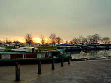 Dawn by the river Great Ouse, Ely
The former RAF hospital based in Ely meant that many children of serving RAF parents were born in the city. These include rugby union player and Rugby World Cup 2003 winning manager with England national rugby union team, Clive Woodward,[147] Australian émigrée actor Guy Pearce,[148] and actor Simon MacCorkindale.[149] Autogyro world record holder Ken Wallis was also born in Ely. Other notable people from Ely include The Sisters of Mercy singer Andrew Eldritch,[150] and journalist Chris Hunt.[151] Crime writer Jim Kelly[152] and award winning poet Wendy Cope[153] currently live in the city.
Cultural references
Children's book Tom's Midnight Garden by Philippa Pearce is partly set in Ely and includes a scene in Ely Cathedral and scenes inspired by the author's father's own childhood experiences of skating along the frozen river from Cambridge to Ely in the frost of 1894–95.[154][155][156] The first series of Jim Kelly's crime novels, featuring fictional journalist Philip Dryden, is largely set in the author's home town of Ely and in the Fens.[157]
See also
References
- Footnotes
- ^ Roswell Pits are also known as Roslyn Hole[3] and Roslyn Pit[4]
- ^ Taken from Dorman 1986 p. 54[21] which originates from John Speed's plan of Ely on his 1610 Huntingdonshire map[22]
- ^ According to Dorman[27]
- ^ "Largest ...", according to Miller and Skertchley (1878) "... by reason of its magnitude, its almost unbroken flatness, and its fertility".[44]
- ^ There was no census in 1941 due to WWII
- ^ Cobbett writes "I do not claim that this stone formed part of Ethelreda's original monastery, and is of seventh century date, though this is just possible; but rather that it belonged to the monastery which she founded in 673 and was carried on by her royal sisters after her death".[92]
- ^ By kind permission of the Cambridgeshire Library Service
- ^ OED pile, n. 2. a. "A large building or edifice, esp. a stately home"(subscription required)
- ^ Dorman calls it Akerman Street[113]
- Notes
- ^ Andrews 2004, p. 596
- ^ a b "Historic Census Population Figures" (XLS). Cambridgeshire County Council. 2010. http://www.cambridgeshire.gov.uk/NR/rdonlyres/C36C6418-DEFD-4ED1-B050-9984100DF110/0/HistCensusEastCambs0106.xls. Retrieved 20 August 2010.
- ^ Skertchly 1877, p. 236
- ^ Marr & Thomas 1967, p. 19
- ^ Stubbington, Paul (2008). "Ely master plan: report number 14555/02/PS/JFR: Infrastructure and constraints assessment". Cambridgeshire Horizons. p. 2. http://www.urbed.com/cgi-bin/get_binary_doc_object.cgi?doc_id=276&fname=extra_pdf_2.pdf. Retrieved 14 November 2011.
- ^ "Cambridgeshire, Ely". The Domesday Book Online. 1999–2010. http://www.domesdaybook.co.uk/cambridgeshire1.html. Retrieved 22 October 2011.
- ^ Mills 1998, p. 178
- ^ "A Brief History of the Diocese of Ely". The Diocese of Ely. The Diocese of Ely limited. http://www.ely.anglican.org/about/brief_history.html. Retrieved 30 October 2011.
- ^ Miller 1953, p. 1
- ^ a b Marr & Thomas 1967, p. 1
- ^ "Peasants’ Revolt affected most of East Anglian towns". EDP24. 17 May 2007. http://www.edp24.co.uk/norfolk-life/peasants_revolt_affected_most_of_east_anglian_towns_1_248374. Retrieved 26 October 2011.
- ^ plant, David (2007-05-18). "British Civil Wars, Commonwealth and Protectorate 1638-1660". British-civil-wars.co.uk. http://www.british-civil-wars.co.uk/biog/oliver-cromwell.htm. Retrieved 2010-07-17.
- ^ Details from listed building database (48811) - St Mary's vicarage, 29 St Mary's Street (south side) (Grade II*). Images of England. English Heritage. Retrieved 31 October 2011.
- ^ "Land and possessions the poor of Ely otherwise Parsons' Charity: reg 202634". Charity Commission. HMG (Crown). http://www.charity-commission.gov.uk/Showcharity/RegisterOfCharities/CharityWithoutPartB.aspx?RegisteredCharityNumber=202634&SubsidiaryNumber=0. Retrieved 31 October 2011.
- ^ Dorman 1986, p. 48
- ^ Letters, Samantha (15 July 2010). "Ely". Online Gazetteer of Markets and Fairs in England Wales to 1516. Institute of Historical research. http://www.history.ac.uk/cmh/gaz/gazweb2.html. Retrieved 14 November 2011.
- ^ "Tawdry lace". Oxford English Dictionary. Oxford University Press. http://www.oed.com/view/Entry/198240. Retrieved 9 November 2011.(subscription required)
- ^ "Tawdry". Oxford English Dictionary. Oxford University Press. http://www.oed.com/view/Entry/198239. Retrieved 9 November 2011.(subscription required)
- ^ Hampson & Atkinson 1953, pp. 43 44
- ^ "Ely. Draft Report". Cambridgeshire Extensive Urban Survey:. Cambridgeshire County Council Archaeology Unit. 17 January 2001. p. 43. http://www.cambridgeshire.gov.uk/NR/rdonlyres/6E15077F-AB5B-4B0B-99B7-788D70B1F035/0/EUSECambsEly.pdf. Retrieved 19 November 2011.
- ^ Dorman 1986, p. 54
- ^ Speed, John. "Huntingdonshire: From a proof copy of John Speed's Theatre of the Empire of Great Britaine, which was first published 1611/12. Cambridge University Library classmark: Atlas.2.61.1". John Speed proof maps - Atlas.2.61.1. Cambridge University Library. http://www.lib.cam.ac.uk/deptserv/maps/speed.html. Retrieved 12 November 2011.
- ^ "Extensive Urban Survey", Leisure-archaeology-record-projects-Ely (Cambridgeshire County Council), 21 December 2007, http://www.cambridgeshire.gov.uk/leisure/archaeology/record/projects/exturbsur/eastcambs/EUS-Ely.htm, retrieved 18 November 2011
- ^ Camden, William (2009) [1607], "Norfolk and Cambridgeshire", A vision of Britain through time (University of Portsmouth and others), http://www.visionofbritain.org.uk/text/chap_page.jsp?t_id=Camden&c_id=17, retrieved 19 November 2011
- ^ Fiennes, Celia (2009) [1698], "1698 Tour: Cambridge to Lichfield", A vision of Britain through time (University of Portsmouth and others), http://www.visionofbritain.org.uk/text/chap_page.jsp?t_id=Fiennes&c_id=20, retrieved 19 November 2011
- ^ Defoe 1891, pp. 152–153
- ^ a b Dorman 1986, p. 74
- ^ Cobbett 1912, p. 228
- ^ Johnson 1893, pp. 12–24; 65–66
- ^ Dorman 1986, p. 81
- ^ Saward, Jeff. "Historic Church Labyrinths in England". Labarinthos: Labyrinths & Mazes Resource Centre, Photo Library & Archive. Labyrinthos. http://www.labyrinthos.net/churchlabuk.html. Retrieved 14 November 2011.
- ^ Hampson & Atkinson 1953, p. 75
- ^ Jones 1924, p. 3
- ^ a b Pevsner 1977, p. 342
- ^ Blakeman 1990, p. 13
- ^ Speed, John. "Huntingdonshire: From a proof copy of John Speed's Theatre of the Empire of Great Britaine, which was first published 1611/12. Cambridge University Library classmark: Atlas.2.61.1". John Speed proof maps - Atlas.2.61.1. Cambridge University Library. http://www.lib.cam.ac.uk/deptserv/maps/speed.html. Retrieved 12 November 2011.
- ^ Aikin 1800, p. 206
- ^ London Gazette: no. 46255. p. 4401. 4 April 1974. Retrieved 13 October 2011.
- ^ Dalton 2011, p. 503
- ^ "Ely Today". East Cambridgeshire District Council. http://www.eastcambs.gov.uk/sites/default/files/emeto.pdf. Retrieved October 14, 2011.
- ^ Letters, Samantha (15 July 2010). "Ely". Online Gazetteer of Markets and Fairs in England Wales to 1516. Institute of Historical research. http://www.history.ac.uk/cmh/gaz/gazweb2.html. Retrieved 14 November 2011.
- ^ Smith, Lisa; Charlotte Davies (2008). "25, Broad Street, Ely, Cambridgeshire Construction Of Residential Dwellings". Archaeological Monitoring & Recording. Cambridge: Archaeological Solutions. p. 8. http://archaeologydataservice.ac.uk/catalogue/adsdata/arch-481-1/dissemination/pdf/archaeol7-62442_1.pdf. Retrieved 14 November 2011.
- ^ Pearce, Ian (3 July 2006). "Gone for clunch". BBC News. http://www.bbc.co.uk/threecounties/content/articles/2006/06/29/goneforclunch_feature.shtml. Retrieved 12 November 2011.
- ^ Miller & Skertchly 1878, p. 1
- ^ Marr & Thomas 1967, p. 9
- ^ British Geological Survey (1980). Ely (S&D) (Map). 1:50000 (Based on 1st series 1:50000 map part of sheet 173 – 1974 ed.). Section 173. ISBN 0751805734.
- ^ Summers 1976, p. 14
- ^ Defoe 1891, p. 161
- ^ a b Wesley, John (22 November 1774), "Wesley in the Fens", A vision of Britain through time (University of Portsmouth and others), http://www.visionofbritain.org.uk/text/chap_page.jsp?t_id=J_Wesley&c_id=17, retrieved 19 November 2011
- ^ Stubbington, Paul (2008). "Ely master plan: report number 14555/02/PS/JFR: Infrastructure and constraints assessment". Cambridgeshire Horizons. p. 2. http://www.urbed.com/cgi-bin/get_binary_doc_object.cgi?doc_id=276&fname=extra_pdf_2.pdf. Retrieved 14 November 2011.
- ^ Summers 1976, pp. 67 68
- ^ Greig & Martin 1998, p. 305
- ^ "Forecast:East of England". UK Climate Forecasts. http://www.metoffice.gov.uk/weather/uk/ee/ee_forecast_weather.html. Retrieved 5 June 2010.
- ^ "Historical Data:Regional:Cambridge NIAB". UK Climate Summaries. http://www.metoffice.gov.uk/climate/uk/stationdata/cambridgedata.txt. Retrieved 5 June 2010.
- ^ "Ely, United Kingdom". Weather Underground, Inc. 2010. http://www.wunderground.com/cgi-bin/findweather/getForecast?query=ely,%20uk&wuSelect=WEATHER. Retrieved 5 June 2010.
- ^ Summers 1976, p. 10
- ^ Summers 1976, p. 11
- ^ Gallois 1988, p. 1
- ^ Cessford, Alexander & Dickens 2006, pp. 83, 98
- ^ Cessford, Alexander & Dickens 2006, p. 83
- ^ "Babylon Gallery blog". NOTE THIS IS NOT AN RS SOURCE. ADrCArts. http://babylongallery-blog.co.uk/?page_id=37. Retrieved 16 November 2011.
- ^ Denison, Simon, ed (October 2000). "News: Post-medieval pottery collection found in Ely". British Archaeology (55). ISSN 1357-4442.
- ^ "Your Councillors". Cambridgeshire County Council. http://www.cambridgeshire.gov.uk/cmswebsite/apps/committees/Members.aspx?by=ward. Retrieved November 08, 2011.
- ^ "Local Government Act 1972 - Schedule 1". http://www.legislation.gov.uk/ukpga/1972/70/schedule/1. Retrieved November 08, 2011.
- ^ "East Cambridgeshire District Council - What kind of Council Are We?". East Cambridgeshire District Council. http://www.eastcambs.gov.uk/east-cambs-district-council/council-profile. Retrieved November 08, 2011.
- ^ "Wards". East Cambridgeshire District Council. http://www.eastcambs.gov.uk/democracy/democracy-elections/Wards. Retrieved November 08, 2011.
- ^ "Search for District Councillors". East Cambridgeshire District Council. http://www.eastcambs.gov.uk/council-and-democracy/search-for-councillors. Retrieved November 08, 2011.
- ^ Isle of Ely. "Hansard 1805-2005 Constituencies". Hansard. http://hansard.millbanksystems.com/constituencies/isle-of-ely. Retrieved 26 October 2011.
- ^ Pym, Francis. "Hansard 1805-2005 People". Hansard. http://hansard.millbanksystems.com/people/mr-clement-freud. Retrieved 26 October 2011.
- ^ Cambridgeshire South East. "Hansard 1805-2005 Constituencies". Hansard. http://hansard.millbanksystems.com/constituencies/cambridgeshire-south-east. Retrieved 26 October 2011.
- ^ Pym, Francis. "Hansard 1805-2005 People". Hansard. http://hansard.millbanksystems.com/people/mr-francis-pym. Retrieved 26 October 2011.
- ^ Pym, Francis. "Hansard 1805-2005 People". Hansard. http://hansard.millbanksystems.com/people/mr-jim-paice. Retrieved 26 October 2011.
- ^ "Jim Paice MP: Minister of State for Agriculture and Food". Department for Environment Food and Rural Affairs. DEFRA. http://www.defra.gov.uk/corporate/about/who/ministers/paice/. Retrieved 26 October 2011.
- ^ "Ely Aquafest". Ely Aquafest. Rotary clubs of Ely. http://www.elyaquafest.org.uk/. Retrieved 2 November 2011.
- ^ "Eely best place to spend your weekend" (Press release). East Cambridgeshire District Council. 15/04/2011. http://www.eastcambs.gov.uk/press/eely-best-place-spend-your-weekend. Retrieved 30 October 2011.
- ^ "Ely Fireworks - Back With A Bang In 2011!". Ely People. Northcliffe Media Limited. 12 October 2011. http://www.elypeople.co.uk/Ely-Fireworks-Bang-2011/story-13539691-detail/story.html. Retrieved 30 October 2011.
- ^ "The 2011 Ely Folk Festival Has It All". Ely People. Northcliffe Media Limited. 22 June 2011. http://www.elypeople.co.uk/2011-Ely-Folk-Festival/story-12813953-detail/story.html. Retrieved 30 October 2011.
- ^ "Ely Horticultural Society 2011 Great Autumn Show". Ely People. Northcliffe Media Limited. 1 September 2011. http://www.elypeople.co.uk/pictures/Ely-Horticultural-Society-2011-Great-Autumn/pictures-13242421-detail/pictures.html. Retrieved 30 October 2011.
- ^ Ely city council. "Ely/Ribe association". Cambridgeshire dot net. http://www.cambridgeshire.net/organisation/elyribe-association/7810.aspx. Retrieved 21 October 2011.
- ^ "Historic Golden Threads". EDP 24. 23 March 2006. http://www.edp24.co.uk/news/historic_golden_threads_1_257485. Retrieved 21 October 2011.
- ^ a b "Cannon on The Green". (This web site is not WP:RS but will do until something better is found). UK Attraction. http://www.ukattraction.com/east-of-england/canon-on-the-green.htm. Retrieved 31 October 2011.
- ^ a b Grytr. "Peaceful inscription: Commemorative inscription alongside the cannon displayed on the green outide Ely Cathedral". Flickr. Flickr/Yahoo. http://www.flickr.com/photos/grytr/269234071. Retrieved 8 November 2011.
- ^ "Listed Buildings". English Heritage. http://www.english-heritage.org.uk/caring/listing/listed-buildings/. Retrieved 24 May 2011.
- ^ "County: Cambridgeshire; Postal town: ELY; Place name: Ely; Building grade: Grade I". National Monument Record. English Heritage. http://www.heritagegateway.org.uk/gateway/. Retrieved 15 November 2011.(registration required)
- ^ Hampson & Atkinson 1953, p. 28
- ^ Pevsner 1977, p. 380
- ^ Pevsner 1977, p. 376
- ^ Details from listed building database (48777) - St John's Farmhouse medieval (Grade I). Images of England. English Heritage. Retrieved 31 October 2011.
- ^ Details from listed building database (48781) - Barn to south-west of St John's Farmhouse (Grade I). Images of England. English Heritage. Retrieved 31 October 2011.
- ^ Details from listed building database (48778) - Barn to north of St John's Farmhouse (Grade I). Images of England. English Heritage. Retrieved 31 October 2011.
- ^ Details from listed building database (48779) -Dovecote to St John's Farm (Grade I). Images of England. English Heritage. Retrieved 31 October 2011.
- ^ Cobbett, L (27 May 1935). "The hospitals of St John the Baptist and St Mary Magdalene at Ely, and the remains of Gothic buildings still to be seen there at St John's Farm". Proceedings of the Cambridge Antiquarian Society. 1932–1936 Vol. 34–37: 73.
- ^ "Hospitals of St Mary Magdalene and St John the Baptist". National Monument Records: Pastscape. English Heritage. http://www.pastscape.org.uk/hob.aspx?hob_id=375292&sort=4&search=all&criteria=Ely%20cathedral&rational=q&recordsperpage=10. Retrieved 8 November 2011.
- ^ Pevsner 1977, p. 382
- ^ Details from listed building database (48811) - St Mary's vicarage (Grade II*). Images of England. English Heritage. Retrieved 8 November 2011.
- ^ "Oliver Cromwell's House". Council web site. East Cambridgeshire District Coucil. http://visitely.eastcambs.gov.uk/cromwell/oliver-cromwells-house. Retrieved 8 November 2011.
- ^ "What is to become of the Ely Courthouse?". Ely People. 8 April 2007. http://www.elypeople.co.uk/news/Ely-Courthouse/story-10936741-detail/story.html. Retrieved 4 November 2011.
- ^ "Ely Magistrates' Court closes doors for the last time". BBC. 2011-03-24. http://www.bbc.co.uk/news/uk-england-cambridgeshire-12847768. Retrieved 2011-04-14.
- ^ "Roswell Pits". The Wildlife Trusts. Bedfordshire, Cambridgeshire and Northamptonshire Wildlife Trusts. http://www.wildlifebcnp.org/reserves/reserve.php?reserveid=63. Retrieved 8 November 2011.
- ^ "Abbey Park". Heritage Gateway. English Heritage. http://www.heritagegateway.org.uk/Gateway/Results_Single.aspx?uid=6184&resourceID=300. Retrieved 8 November 2011.
- ^ "Abbey Park". Parks & Gardens UK. The Association of Gardens Trusts and the University of York. http://www.parksandgardens.ac.uk/component/option,com_parksandgardens/task,site/id,6184/tab,description/Itemid,/. Retrieved 8 November 2011.
- ^ Dorman 1986, p. 55
- ^ Russell, Nigel. "Chettisham Meadows: SSSI reference 1000052". Natural England. UK Government. http://www.sssi.naturalengland.org.uk/special/sssi/unit_details.cfm?situnt_id=1000052. Retrieved 14 November 2011.
- ^ Stubbington, Paul (2008). "Ely master plan: report number 14555/02/PS/JFR: Infrastructure and constraints assessment". Cambridgeshire Horizons. p. 18. http://www.urbed.com/cgi-bin/get_binary_doc_object.cgi?doc_id=276&fname=extra_pdf_2.pdf. Retrieved 14 November 2011.
- ^ a b c "The East Anglian Railway". The Illustrated London News (Strand, London): p. 277. 30 October 1847.
- ^ Stubbington, Paul (2008). "Ely master plan: report number 14555/02/PS/JFR: Infrastructure and constraints assessment". Cambridgeshire Horizons. p. 4. http://www.urbed.com/cgi-bin/get_binary_doc_object.cgi?doc_id=276&fname=extra_pdf_2.pdf. Retrieved 14 November 2011.
- ^ Pevsner 1977, p. 381
- ^ Dale 2000, p. 78
- ^ Oppitz (1989) pp. 58–59
- ^ Using RPI as described in Choosing the Best Indicator to Measure Relative Worth
- ^ UK CPI inflation numbers based on data available from Lawrence H. Officer (2010) "What Were the UK Earnings and Prices Then?" MeasuringWorth.
- ^ Dale 2000, p. 28
- ^ Dorman 1986, p. 3
- ^ Babington 1853, pp. 10–12
- ^ Babington 1953, p. 17
- ^ Stewart 1868, pp. 195–196
- ^ Babington 1853, p. 16
- ^ Gray & Stubbings 2000, pp. 2–3
- ^ Hampton & Atkinson 1953, p. 44
- ^ Hampson & Atkinson 1953, p. 32
- ^ Cary 1817, p. 58
- ^ John Cary. The Road from London to Cambridge, Ely, & Kings Lynn (Map) (7 ed.). http://www.maproom.org/00/18/present.php?m=0001. Retrieved 7 November 2011.
- ^ "Ely. Draft Report". Cambridgeshire Extensive Urban Survey:. Cambridgeshire County Council Archaeology Unit. 17 January 2001. p. 44. http://www.cambridgeshire.gov.uk/NR/rdonlyres/6E15077F-AB5B-4B0B-99B7-788D70B1F035/0/EUSECambsEly.pdf. Retrieved 19 November 2011.
- ^ "Bypass bid to cut jams at crossing". Cambridge Evening News. 25 October 2011. http://www.cambridge-news.co.uk/Home/Bypass-bid-to-cut-jams-at-crossing-25102011.htm. Retrieved 4 November 2011.
- ^ "Have Your Say On The Ely Crossing". Ely People. 18 October 2011. http://www.elypeople.co.uk/Say-Ely-Crossing/story-13590240-detail/story.html. Retrieved 4 November 2011.
- ^ Day, Jordan (19 October 2011). "Tesco's plans for larger store welcomed by some residents". Cambridge Evening News. http://www.cambridge-news.co.uk/Home/Get-with-it-message-for-Tesco-opponents-19102011.htm. Retrieved 4 November 2011.
- ^ "Ely Cathedral". EDP24. 15 April 2010. http://www.edp24.co.uk/norfolk-life/norfolk-history/35_ely_cathedral_1_214306. Retrieved 27 October 2011.
- ^ "Ely Cathedral website". Elycathedral.org. http://www.elycathedral.org/history/ship_of_the_fens.html. Retrieved 2010-07-17.
- ^ "Ely Cathedral". About Britain. Excelsior Information Systems. 2011. http://www.aboutbritain.com/elycathedral.htm. Retrieved 4 November 2011.
- ^ Hampson & Atkinson1953, p. 62
- ^ "About the Diocese". Diocese of Ely. Diocese of Ely Ltd. 2011. http://www.ely.anglican.org/about/about.html. Retrieved 26 October 2011.
- ^ Pevsner 1977, p. 379
- ^ Hampson & Atkinson 1953, p. 83
- ^ a b Hampson & Atkinson 1953, p. 86
- ^ Hampson & Atkinson 1953, p. 87
- ^ Pevsner 1977, p. 380
- ^ Bauckham 2006
- ^ "Facilities". Cambridge University Boat Club (CUBC). CUBC. 2011. http://www.cubc.org.uk/rowing/facilities.html. Retrieved October 15, 2011.
- ^ "Celebrate the 1944 University Boat Race". BBC News. April 2004. http://www.bbc.co.uk/cambridgeshire/out_about/2004/02/historic_boat_race.shtml. Retrieved 15 October 2011.
- ^ Day, Jordan. "School completes academy switch". Ely Weekly News. http://www.cambridge-news.co.uk/Ely/School-completes-academy-switch-11102011.htm. Retrieved 4 November 2011.
- ^ "Your Area:Cambridgeshire County:Ely". Corporate Website. Anglian Water. http://www.anglianwater.co.uk/your-area/incidents/?town=2402. Retrieved 12 November 2011.
- ^ van de Bulk, Paul (31 March 2009). "Renewable Energy Development in Cambridgeshire 1999–2009" (PDF). Cambridgeshire County Council. http://www.cambridgeshire.gov.uk/NR/rdonlyres/9D4357FF-739D-4B85-B9F8-560EBF10D8E0/0/RenewableenergyDevelopmentInCambridgeshire2009.pdf. Retrieved 2 June 2010.
- ^ "Select Committee on Science and Technology Fourth Report:Appendix 6: Visit To Elean And Thetford Power StationS". House of Lords. 30 January 2004. http://www.publications.parliament.uk/pa/ld200304/ldselect/ldsctech/126/12618.htm. Retrieved 7 June 2010.
- ^ "Recap Partnership". RECAP. http://www.recap.co.uk/recap-partnership/. Retrieved June 2010.
- ^ "NHS Choices–your health, your choices". Nearest surgery to Ely. National Health Service (NHS). http://www.nhs.uk/ServiceDirectories/Pages/GP.aspx?pid=1533745F-3EB1-4D28-9808-531818C20223. Retrieved 12 November 2011.
- ^ "Ely. Draft Report". Cambridgeshire Extensive Urban Survey:. Cambridgeshire County Council Archaeology Unit. 17 January 2001. p. 43. http://www.cambridgeshire.gov.uk/NR/rdonlyres/6E15077F-AB5B-4B0B-99B7-788D70B1F035/0/EUSECambsEly.pdf. Retrieved 19 November 2011.
- ^ "ESPN Scrum: Clive Woodward, England". ESPN EMEA. http://www.espnscrum.com/england/rugby/player/9091.html. Retrieved 2001-05-17.
- ^ "Guy Pearce: He's come a long way since 'Neighbours'". London: The Independent. 26 February 2006. http://www.independent.co.uk/news/people/profiles/guy-pearce-hes-come-a-long-way-since-neighbours-467405.html. Retrieved 17 May 2011.
- ^ "Simon MacCorkindale". London. 15 October 2010. http://www.telegraph.co.uk/news/obituaries/culture-obituaries/tv-radio-obituaries/8067423/Simon-MacCorkindale.html. Retrieved 4 November 2011.
- ^ Betts 2005, p. 370
- ^ The columnists (2004–2011). "Who the hell is Chris Hunt?". Karl Bedingfield. http://www.elyonline.co.uk/archives/author/ch/. Retrieved 30 October 2011.
- ^ "Jim Kelly". Penguin Books. Pearson. http://www.penguin.co.uk/nf/Author/AuthorPage/0,,1000056454,00.html. Retrieved 30 October 2011.
- ^ "Poet reveals her book inspiration". Ely Weekly News. 18/05/2011. http://www.cambridge-news.co.uk/Ely/Poet-reveals-her-book-inspiration-18052011.htm. Retrieved 30 October 2011.
- ^ "Philipa Pearce". Daily Telegraph. 27 December 2006. http://www.telegraph.co.uk/news/obituaries/1537873/Philippa-Pearce.html. Retrieved 4 November 2011.
- ^ Wood, David (2008). "Taking Tom from Page to Stage". The Philippa Pearce Memorial Lecture. Pearce Memorial Charity: reg. 256277. http://www.pearcelecture.com/materials/DWood_TakingTom.pdf. Retrieved 30 October 2011.
- ^ Pullman, Philip (2011). "Both Perhaps and Present". The Philippa Pearce Memorial Lecture. Pearce Memorial Charity: reg. 256277. http://www.pearcelecture.com/materials/PPullman_BothPerhapsPresent.pdf. Retrieved 30 October 2011.
- ^ "Maggi Hambling’s The Aldeburgh Scallop wins award". Evening Star. 9 September 2011. http://www.eveningstar.co.uk/entertainment/news/maggi_hambling_s_the_aldeburgh_scallop_wins_award_1_1016132. Retrieved 3 November 2011.
- Bibliography
- Aikin, John (1800), England delineated (IV ed.), J. Johnson, http://books.google.com/books?id=CJBFAAAAIAAJ
- Andrews, Robert (2004), Rough guide to England, ISBN 9781843532491, http://books.google.co.uk/books?id=sXrZmU-2TsoC
- Babington, Charles Cardale (1853), "Ancient Cambridgeshire", Publications of the Cambridge Antiquarian Society (Oxford University) (3), http://books.google.co.uk/books?id=WRMVAAAAQAAJ
- Bauckham, David (2006), Dugouts, New Holland Publishers, ISBN 1845374789
- Bentham, James (1771), The history and antiquities of the conventual & cathedral Church of Ely: from the foundation of the Monastery A. D. 673 to the year 1771, Vol. I, Cambridge University Press, http://books.google.co.uk/books?id=y_5BAAAAYAAJ
- Bentham, James (1817), The history and antiquities of the conventual & cathedral Church of Ely: from the foundation of the Monastery A. D. 673 to the year 1771: Supplement : comprising enlarged accounts of the monastery, Lady Chapel, Prior Crawden's Chapel, the places and other buildings connected with the ..., Vol. III, Stevenson, http://books.google.co.uk/books?id=djI_AAAAcAAJ
- Betts, Graham (2005), Collins complete British hit albums, Collins, ISBN 9780007205325
- Blakeman, Pamela (1990), The book of Ely, Barracuda Books, ISBN 0860234665
- Cary, John (1817), Cary's New itinerary; or, An accurate delineation of the great roads ... throughout England and Wales; with many of the principal roads in Scotland etc, His Majesties Postmaster General, http://books.google.co.uk/books?id=sZ1bAAAAQAAJ
- Cessford, Craig; Alexander, Mary; Dickens, Alison (2006), "Between Broad Street and the Great Ouse: waterfront archaeology in Ely", East Anglian Archaeology (Cambridge Archaeology Unit) Report No. 114
- Cobbett, William (1912), Rural Rides, London: Dent, pp. 229–233, http://www.archive.org/stream/ruralrides02cobb#page/228/mode/2up, retrieved 11 November 2011
- Dale, Rodney (2000), Haddenham & Aldreth Past and Present, Fern House, ISBN 1-902702-06-9
- Dalton, Nick; Rebecca Ford, Donald Strachan, Stephen Keeling, Deborah Stone, Rhonda Carrier, Louise McGrath (2011), Frommer's England & the Best of Wales 2012, John Wiley & Sons, ISBN 9781119972570
- Defoe, Daniel (1891) [1722], A tour through the eastern counties of England, 1722, London, Paris, Melbourne: Cassell, http://books.google.co.uk/books?id=31xDAAAAYAAJ, retrieved 12 November 2011
- Dorman, B E (1986) [1945], The story of Ely (7 ed.), Norwich: Black Horse
- Gallois, R W; Beris M Cox, H C Ivimey-Cook, A A Morter, R S Seale (1988), Geology of the country around Ely: Memoir for 1:50 000 geological sheet 173 (England and Wales), London: HMSO: British Geological Survey, ISBN 0118843958
- Gray, Ronald D; Stubbings, Derek (2000), Cambridge street-names: their origins and associations, Cambridge, United Kingdom: Cambridge University Press, ISBN 9780521789561, http://books.google.co.uk/books?id=Z1_EN9lkfXQC
- Greig, A; Martin, J (1998) (PDF), Cambridgeshire and Peterborough's State of the Environment Report, Cambridgeshire County Council, http://www.cambridgeshire.gov.uk/NR/rdonlyres/2F0D5E30-F308-406B-9455-86B9EDDD50EC/0/soe98physical.pdf, retrieved 3 November 2011
- Hampson, Ethel M; Atkinson, T D (1953), "Chapter 2: City of Ely", in Pugh, Ralph B, The Victoria History of the Counties of England: A history of Cambridge and the Isle of Ely, Vol. IV, London: for The University of London Institute of Historical Research by the Oxford University Press, pp. 27–89, http://www.british-history.ac.uk/report.aspx?compid=21883
- Johnson, C (1893), An account of the Ely and Littleport riots in 1816, Littleport: Harris & Sons, pp. 12–24; 65–66
- Jones, J (1924), A human geography of Cambridgeshire, London: Sidgwick & Jackson
- Marr, J E; Thomas, H D (1967) [1938], "Chapter 1: Geology", in Salzman, L F, The Victoria History of the Counties of England: Cambridgeshire and the Isle of Ely, Vol. I, London: for The University of London Institute of Historical Research reprinted by Dawsons of Pall Mall, pp. 1–33
- Miller, Edward (1953), "Chapter 1: The Liberty of Ely", in Pugh, Ralph B, The Victoria History of the Counties of England: A history of Cambridge and the Isle of Ely, Vol. IV, London: for The University of London Institute of Historical Research by the Oxford University Press, pp. 1–27, http://www.british-history.ac.uk/report.aspx?compid=21879
- Miller, Samuel H; Skertchly, Sydney B J (1878), "Chapter 1: Geographical sketch of the Fenland", The Fenland past and present, London: Longmans & Green, pp. 1–13
- Mills, A D (1998) [1991], A dictionary of British place-names, Oxford University Press, ISBN 0198527586
- Oppitz, Leslie (1989), East Anglia railways remembered, Countryside Books, ISBN 1-85306-040-2
- Pevsner, Nikolaus (1977) [1954], The buildings of England: Cambridgeshire (2nd ed.), Penguin books, ISBN 0140710108
- Skertchly, S B J (1877), Geology of the Fenland, London: M Stationary Office, http://books.google.co.uk/books?id=DXYKAAAAMAAJ
- Stewart, D J (1868), On the architectural history of Ely Cathedral, London: John van Voorst, http://books.google.co.uk/books?id=evoDAAAAYAAJ
- Summers, Dorothy (1976), The Great Level: A history of drainage and land reclamation in the Fens, London: David & Charles, ISBN 0715370413
External links
Cities Ely
Towns Villages Aldreth • Ashley • Barway • Bottisham • Brinkley • Burwell • Chettisham • Cheveley • Chippenham • Coveney • Dullingham • Fordham • Haddenham • Isleham • Little Downham • Little Thetford • Littleport • Lode • Longmeadow • Mepal • Prickwillow • Pymoor • Queen Adelaide • Reach • Stetchworth • Stretham • Stuntney • Sutton • Swaffham Bulbeck • Swaffham Prior • Upware • Wicken • Wilburton • Witcham • Witchford • WooddittonCivil Parishes Cities of the United Kingdom England Bath · Birmingham · Bradford · Brighton and Hove · Bristol · Cambridge · Canterbury · Carlisle · Chester · Chichester · Coventry · Derby · Durham · Ely · Exeter · Gloucester · Hereford · Kingston upon Hull · Lancaster · Leeds · Leicester · Lichfield · Lincoln · Liverpool · London · Manchester · Newcastle upon Tyne · Norwich · Nottingham · Oxford · Peterborough · Plymouth · Portsmouth · Preston · Ripon · St Albans · Salford · Salisbury · Sheffield · Southampton · Stoke-on-Trent · Sunderland · Truro · Wakefield · Wells · Westminster · Winchester · Wolverhampton · Worcester · York
Scotland Wales Northern Ireland Categories:- 673 establishments
- Ely, Cambridgeshire
- Populated places on the River Great Ouse
- Civil parishes in Cambridgeshire
- Cities in the East of England


Wikimedia Foundation. 2010.