- Salisbury
-
This article is about the city in the United Kingdom. For the capital of Zimbabwe formerly named Salisbury, see Harare. For other uses, see Salisbury (disambiguation).
Coordinates: 51°04′26″N 1°47′37″W / 51.0740°N 1.7936°W
Salisbury City of New Sarum 
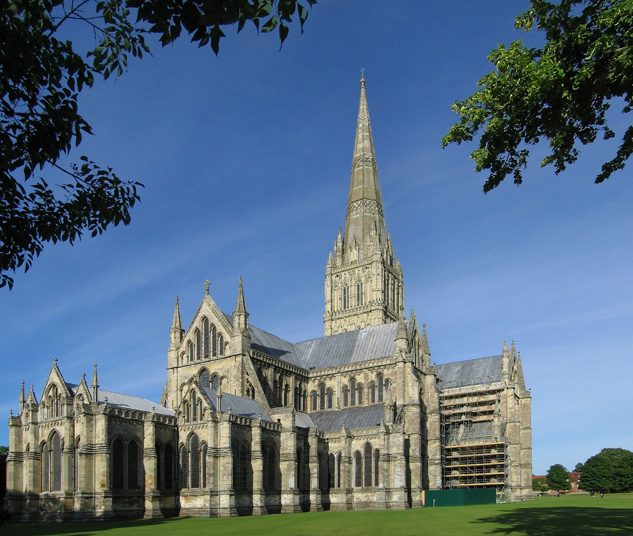
Salisbury Cathedral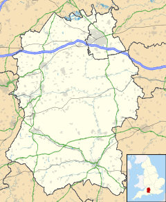
 Salisbury
Salisbury shown within WiltshirePopulation 39,726 2001 census OS grid reference SU145305 - London 85 miles (137 km) Parish City of Salisbury Unitary authority Wiltshire Ceremonial county Wiltshire Region South West Country England Sovereign state United Kingdom Post town SALISBURY Postcode district SP1, SP2 Dialling code 01722 Police Wiltshire Fire Wiltshire Ambulance Great Western EU Parliament South West England UK Parliament Salisbury List of places: UK • England • Wiltshire Salisbury (
 /ˈsɔːlzbri/ sawlz-bree or /ˈsɒlzbri/ solz-bree, or locally /ˈzɔːwzbri/) is a cathedral city in Wiltshire, England and the only city in the county. It is the second largest settlement (with the largest being Swindon) in the county. It has also been called New Sarum to distinguish it from the original site of settlement to the north of the city at Old Sarum, but this alternative name is not in common use.
The city is located in the south-east of Wiltshire, near the edge of Salisbury Plain. It sits at the confluence of five rivers: the Nadder, Ebble, Wylye and Bourne are tributary to the Avon, which flows to the south coast and into the sea at Christchurch, Dorset. Salisbury railway station serves the city, and is the crossing point between the West of England Main Line and the Wessex Main Line making it a regional interchange.
Contents
History
Although the actual city was not established until 1220, there has been a settlement in the area since prehistory. There is evidence of Neolithic settlement on the hilltop of Old Sarum, which became a hill fort in the Iron Age. The Romans called this fort "Sorviodunum" and may also have occupied the fort. The Saxons established themselves there called it "Searesbyrig"[1][2][3] and the Normans built a castle or "Seresberi". By 1086, in the Domesday Book, it was called "Salesberie".[4]
The first Salisbury Cathedral was built on the hill by St Bishop Osmund between 1075 and 1092. A larger building was built on the same site circa 1120. However, deteriorating relations between the clergy and the military at Old Sarum led to the decision to re-site the cathedral elsewhere. Even in the 12th century, Peter of Blois had described the old church as "a captive within the walls of the citadel like the ark of God in the profane house of Baal". He made the appeal -
Let us descend into the plain! There are rich fields and fertile valleys abounding in the fruits of the earth and watered by the living stream. There is a seat for the Virgin Patroness of our church to which the world cannot produce a parallel.[5]
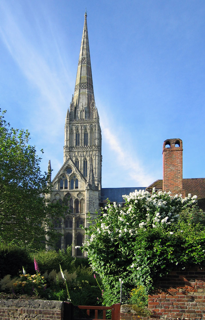
The logic of this was inescapable, and in 1220 the city of New Sarum, now known as Salisbury, was founded on a great meadow called 'Merrifield'.[5] The building of the new cathedral was begun by Bishop Richard Poore in the same year. The main body was completed in only 38 years and is a masterpiece of Early English architecture. Some stones which make up the cathedral came from Old Sarum, others from the Chilmark Quarries from where they were most likely moved to the cathedral building site by ox-cart. The existence of many water-mills and weirs probably prevented transport via boats on the River Nadder. The 123 m (404 ft) tall spire was built later and is the tallest spire in the UK.
The cathedral is built on a gravel bed with unusually shallow foundations of 18 inches (46 cm) upon wooden faggots: the site is supposed to have been selected by shooting an arrow from Old Sarum, although this can only be legend as the distance is over 3 kilometres (1.9 mi). It is sometimes claimed the arrow hit a white deer, which continued to run and died on the spot where the Cathedral now exists. The cathedral contains the best preserved of the four surviving copies of the Magna Carta and a large mechanical clock installed in the cathedral in 1386 - the oldest surviving mechanical clock in Britain.
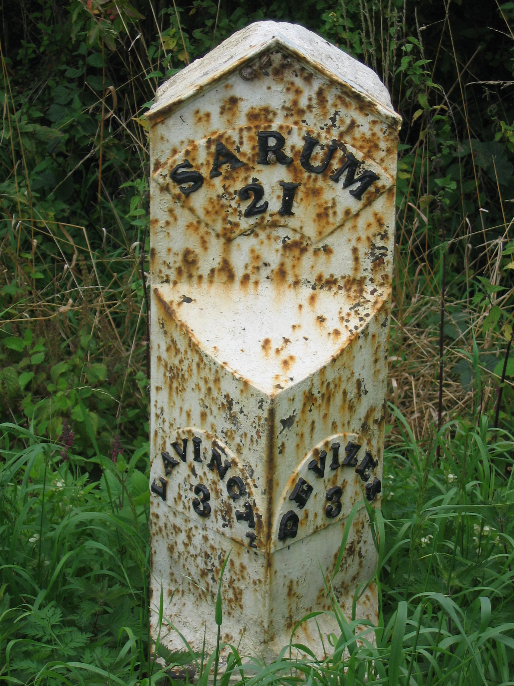
 19th century milestone refers to the city as Sarum
The original site of the city at Old Sarum fell into disuse. Old Sarum was a rotten borough that was abolished as at the time, one MP represented three households. The bury element is a form of borough, which has cognates in words and place names throughout the Germanic languages. For a fuller explanation, see borough.
The origins of the name "Sarum" are obscure. It most likely derives from the fact that Sarum came into use when documents were written in contracted Latin. It was easier to write Sar with a stroke over the "r", than write the complete word "Saresberie". That mark was also the common symbol for the Latin termination "um". Hence "Sar" with a stroke over the r was copied as "SarUM". One of the first known uses of "Sarum" is on the seal of Saint Nicholas Hospital, Salisbury, which was in use in 1239. Bishop Wyville (1330–1375) was the first Bishop to describe himself "episcopus Sarum".[6]
The City
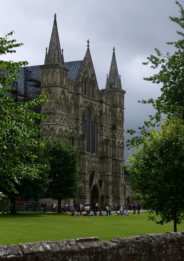
 Great West Front of Salisbury Cathedral
In 1219 Richard Poore, the then Bishop of Sarum, decided to establish a new town and cathedral on an estate in his possession (confusingly known as Veteres Sarisberias - Old Salisburys) in the valley, on the banks of the River Avon.
The town was laid out in a grid pattern, and work started in 1220, with the cathedral commencing the following year. The town developed rapidly, and by the 14th century was the foremost town in Wiltshire. The city wall surrounds the Close and was built in the 14th century.
There are five gates in the wall; four are original, known as the High Street Gate, St Ann's Gate, the Queen's Gate, and St Nicholas's Gate. A fifth was created in the 19th century to allow access to Bishop Wordsworth's School located inside the Cathedral Close. A room located above St Ann's Gate is where the composer Handel stayed, writing several works while there. During the Great Plague of London, Charles II held court in the Close.
The novel Sarum by Edward Rutherfurd, published in 1987, is an imaginative retelling of the history of Salisbury.
Governance
Main articles: Salisbury City Council and Wiltshire Council Salisbury City Council Logo
Salisbury now falls under two authorities created in 2009, Salisbury City Council and Wiltshire Council. It was once at the heart of the now defunct Salisbury District, which oversaw most of south Wiltshire as well as the city. When Wiltshire's local government was reorganised under a unitary authority in April 2009, Salisbury City Council was formed, although with fewer responsibilities than the former district council. The city has one Member of Parliament for the Salisbury constituency, currently John Glen (Conservative) who was elected in the 2010 election.
Geography
 Queen Elizabeth Gardens showing part of the River Avon diverted through the gardens.
Salisbury is located in a valley. The geology of the area, like much of South Wiltshire and Hampshire, is largely chalk. The rivers which flow through the city have been redirected, and along with landscaping, have been used to feed into public gardens. They are popular in the summer, particularly Queen Elizabeth Gardens as the water there is shallow and slow-flowing enough to enter safely. Close to Queen Elizabeth Gardens are water-meadows, where the water is controlled by weirs. Because of the low-lying land, the rivers are prone to flooding particularly during the winter months. The Town Path, a walkway that links Harnham with the rest of the city, is at times impassable.
A cause of concern to the people of Salisbury is the lack of adequate roads. There is no motorway that links the ports of Southampton and Bristol meaning that all traffic must pass through the city.
The closest town is Wilton which is the former county town of Wiltshire. To the north are the towns of Amesbury, which includes Stonehenge and Tidworth. Andover is north east. To the west of the city are Barford St Martin and Tisbury. Alderbury and Romsey are to the south, as is the nearest other city - Southampton.
To the north is Salisbury Plain. Much of this area is used by the British military for training. There are military airfields at Boscombe Down, Middle Wallop, Netheravon and Upavon. There are civil airfields at Old Sarum (where the experimental aircraft the Edgley Optica was developed and tested) and at Thruxton near Andover.
Climate
Salisbury experiences an oceanic climate (Köppen climate classification Cfb) similar to almost all of the United Kingdom. The nearest Met Office weather station to Salisbury is Boscombe Down, about 6 miles to the North of the City Centre. In terms of the local climate, Salisbury is amongst the sunniest of Inland areas in the UK, averaging over 1650 hours of sunshine in a typical year. Temperature extremes since 1960 have ranged from −12.4 °C (9.7 °F) in January 1963[7] to 34.5 °C (94.1 °F) during July 2006.[8] The lowest temperature to be recorded in recent years was −10.1 °C (13.8 °F) during December 2010.[9]
Climate data for Boscombe Down 126asl, 1971-2000, Extremes 1960- Month Jan Feb Mar Apr May Jun Jul Aug Sep Oct Nov Dec Year Record high °C (°F) 13.6
(56.5)15.7
(60.3)20.6
(69.1)25.9
(78.6)27.5
(81.5)33.7
(92.7)34.5
(94.1)34.2
(93.6)27.8
(82.0)26.2
(79.2)17.6
(63.7)14.3
(57.7)34.5
(94.1)Average high °C (°F) 6.9
(44.4)7.3
(45.1)9.8
(49.6)12.4
(54.3)16.1
(61.0)18.9
(66.0)21.7
(71.1)21.4
(70.5)18.2
(64.8)14.1
(57.4)10.0
(50.0)7.8
(46.0)13.8 Average low °C (°F) 1.1
(34.0)1.0
(33.8)2.8
(37.0)3.8
(38.8)6.8
(44.2)9.5
(49.1)11.8
(53.2)11.7
(53.1)9.6
(49.3)6.9
(44.4)3.6
(38.5)2.2
(36.0)5.7 Record low °C (°F) −12.4
(9.7)−9.6
(14.7)−9.6
(14.7)−4.7
(23.5)−2.4
(27.7)−0.1
(31.8)4.4
(39.9)3.6
(38.5)−0.1
(31.8)−3.4
(25.9)−6.4
(20.5)−11.3
(11.7)−12.4
(9.7)Precipitation mm (inches) 76.4
(3.008)52.9
(2.083)59.0
(2.323)48.2
(1.898)52.1
(2.051)55.1
(2.169)40.5
(1.594)57.1
(2.248)64.5
(2.539)70.9
(2.791)73.2
(2.882)85.9
(3.382)735.6
(28.961)Sunshine hours 58.0 75.4 115.3 169.2 206.8 207.3 223.5 208.3 151.2 113.8 78.3 53.9 1,661.0 Source no. 1: MetOffice[10] Source no. 2: Royal Dutch Meteorological Institute/KNMI[11] Demography
The city itself had a population of 39,726 at the 2001 census.[12] The results of the 2011 census are not yet available, but they are expected to show a substantial increase.
The former Salisbury District, which was abolished in 2009, included the surrounding towns and villages and had an estimated population in 2004 of 115,000, of whom 98.67% of were white, and 96.41% White British. 0.30% of the population were South Asian, 0.16% were Chinese, 0.13% were black and 0.57% were of mixed race.[13]
88.50% of the population were born in England,[14] 4.77% were born elsewhere in the UK, and 3.12% were born elsewhere in the EU (including the Republic of Ireland). 3.60% of the population were born outside of the EU.
78.29% of the population declared their religion as Christianity,[15] while 13.58% stated "no religion" and 7.17% declined to state their religion. The second largest actual religion in Salisbury was Islam with adherents accounting for 0.24% of the population.
Economy
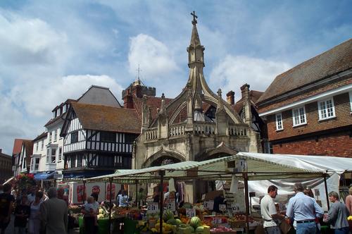
 The 15th century Poultry Cross in the Market Place originally marked the section of the market trading in poultry.
Salisbury holds a market on Tuesdays and Saturdays and has held markets regularly since 1227. In the 15th century the Market Place was dotted with stone crosses marking the centres for certain trades and goods. Today only the Poultry Cross remains, to which flying buttresses were added in 1852. The other crosses were the Livestock Cross, the Cheese & Milk Cross and the Wool & Yarn Cross.
In 1226, King Henry III granted the Bishop of Salisbury a charter to hold a fair lasting 8 days from the Feast of the Assumption of Mary (15 August).[16] Over the centuries the dates for the fair have moved around, but in its modern guise, a funfair is now held in the Market Place for three days from the third Monday in October. However, there is still an ancient law stating that the fair can be held in the Cathedral Close.
Stonehenge, which is a UNESCO World Heritage Site is about 8 miles (13 km) northwest of Salisbury and greatly aids the local economy. The city itself, Old Sarum and the original cathedral also attract visitors.
Shopping centres include The Old George Mall, The Maltings, Winchester Street and the Crosskeys precinct.
Major employers include Salisbury District Hospital and Friends Life.
Culture
 Salisbury High Street
Salisbury was an important centre for music in the 18th century. The grammarian James Harris, a friend of Handel, directed concerts at the Assembly Rooms for almost 50 years up to his death in 1780, with many of the most famous musicians and singers of the day performing there.[17]
Salisbury holds an annual St George's Day pageant, the origins of which are claimed to go back to the thirteenth century.
Salisbury has a strong artistic community, with galleries situated in the city centre, including one in the public library. In the 18th century, John Constable made a number of celebrated landscape paintings featuring the cathedral spire and the surrounding countryside. Salisbury's annual International Arts Festival, started in 1973, and held in late May to early June, provides a programme of theatre, live music, dance, public sculpture, street performance and art exhibitions. Salisbury also houses a producing theatre - Salisbury Playhouse - which produces between eight and ten plays a year, as well as welcoming touring productions.
Salisbury and South Wiltshire Museum
 Salisbury and South Wiltshire Museum, housed in The King's House
The Salisbury and South Wiltshire Museum is housed in the King's House, a Grade I listed building whose history dates back to the 13th century, just opposite the west front of the Cathedral.
The permanent Stonehenge exhibition gallery has interactive displays about Stonehenge and the archaeology of south Wiltshire, and its collections include the skeleton of the Amesbury Archer, which is on display.
The Pitt Rivers gallery holds a collection from General Augustus Pitt Rivers, often called the "father of modern archaeology".[citation needed]
The costume gallery showcases costume and textiles from the area with costumes for children to try on and imagine themselves as characters from Salisbury's past.
Historical events
In May 1289, there was uncertainty about the future of Margaret, Maid of Norway, and her father sent ambassadors to Edward I of England. Edward met Robert the Bruce and others at Salisbury in October 1289, which resulted in the Treaty of Salisbury, under which Margaret would be sent to Scotland before 1 November 1290 and any agreement on her future marriage would be delayed until she was in Scotland.[18]
In 1450, a number of riots broke out at roughly the same time Jack Cade led a famous rebellion through London. The riots were for related reasons to those of Jack Cade and his followers, however the decline of the cloth trade may have also been influential. The violence peaked with the murder of William Ayscough, Bishop of Salisbury. The Bishop was branded a traitor for his involvement in a governing clique perceived responsible for mis-government of the realm by both the rebels in London and Salisbury.
In 1483, a large-scale rebellion against Richard III of England broke out, led by his own 'kingmaker', Henry Stafford, 2nd Duke of Buckingham. After the revolt collapsed, Buckingham was executed at Salisbury, near the Bull's Head Inn.
At the time of the Glorious Revolution, King James II gathered his main forces, altogether about 19,000 men, at Salisbury, James himself arriving in the city on 19 November 1688. His troops were not keen to fight William and Mary, and the loyalty of many of his commanders was in doubt. The first blood was shed at Wincanton, in Somerset. In Salisbury, James heard that some of his officers had deserted, such as Edward Hyde, and he broke out in a nose-bleed which he took as an omen that he should retreat. His commander in chief, the Earl of Feversham, advised retreat on 23 November, and the next day John Churchill deserted to William. On 26 November, James's own daughter, Princess Anne, did the same, and James returned to London the same day, never again to be at the head of a serious military force in England.[19]
At the time of the 1948 Summer Olympics, held in London, a relay of runners carried the Olympic Flame from Wembley Stadium, where the Games were based, to the sailing centre at Torbay via Slough, Basingstoke, Salisbury, and Exeter.
Twinning
Salisbury is twinned with Saintes in France since 1990, and Xanten in Germany since 2006. Salisbury is also a sister city of Salisbury, North Carolina and Salisbury, Maryland, both of which are in the United States.[citation needed]
Schools
There are numerous schools around the area of Salisbury, including the Chafyn Grove School, Leehurst Swan School, the Godolphin senior and prep school and Stonehenge Comprehensive School. Salisbury also includes the only two grammar schools in Wiltshire: South Wilts Grammar School for Girls and Bishop Wordsworth's School, which is for boys.
Transport
The city has a good choice of public transport.[20] There are bus links to Southampton, Bournemouth and Andover working seven days a week with limited services on Sundays. Wilts & Dorset are the main local bus company, part of the Go-Ahead group, with a bus station at 8 Endless Street and a bus yard in Castle Street. Stagecoach in Hampshire runs the number 87 to Andover every two hours from Salisbury and also every other journey on route 8 to Andover via Amesbury and Tidworth along with Wilts & Dorset. Bodman's also runs the number 24 bus between Salisbury and Warminster,[21] which replaced the X4/X5 service which used to run between Salisbury and Bath.
Salisbury railway station is the crossing point of the West of England Main Line, from London Waterloo to Exeter, and the Wessex Main Line from Bristol to Southampton. The station is operated by South West Trains.
Salisbury also has a Park and Ride bus scheme with five sites around the city. These park and ride sites relieve pressure on the city centre but run at an annual loss of £1 million.[22] The Park and Ride sites, which are funded by Wiltshire Council and cost £2.50 for parking and bus transport of up to six passengers, are:[23]
Leisure

- The Bishop's Walk on the edge of the city provides a popular viewing point
- Some buildings in Salisbury are reputed to be haunted. Ghost tours are popular with locals and visitors. One such building is the local Odeon cinema located in the Hall of John Halle - the oldest building in the UK to contain a cinema. The Debenhams department store is said to be haunted by Henry Stafford, 2nd Duke of Buckingham - the store is on the site where he was beheaded in 1483[24]
- The city has a football team, Salisbury City F.C., and a rugby team. Salisbury City football club play in the Conference South division. Their games are at the Raymond McEnhill Stadium on the northern edge of the city.
- The rugby club has produced several England Internationals in recent years and continues to nurture future talent through a buoyant Mini and Youth section. It is seen as one of the prime rugby nurturing centres nationwide, regularly providing County Championship winning sides, County Players at all ages, and academy players for the professional game. Their junior section has also won National tournaments on a regular basis playing finals at Twickenham.
- The Five Rivers Leisure Centre and Swimming Pool is located just outside of the ring road and was opened in 2002
- The local theatre is the Salisbury Playhouse.
- Salisbury is well-supplied with pubs. 'The Haunch of Venison', overlooking the market, still operates from a 14th century building. One of its attractions is a plaster cast of a mummified hand, supposedly severed during a game of cards. The hand vanished in 2004 as a publicity stunt for the pub but later reappeared and can still be seen there.[25] The Rai d’Or has original deeds dating from 1292. It was the home of Agnes Bottenham who used the profits of the tavern to found Trinity Hospital next door in around 1380.
- The City Hall is an entertainment venue and hosts comedy, musical performances as well as seminars and conventions
- Salisbury Racecourse is a flat racing course to the south-west of the city
- Salisbury Arts Centre [26] has exhibitions and workshops.
Media
Salisbury is served by two local radio stations. Spire FM is the Independent Local Radio station, and BBC Wiltshire is the BBC Local Radio public service station for the whole county. Regional television services are provided by BBC South and ITV Meridian.
The Salisbury Journal is the local paid for weekly newspaper which is available in shops every Thursday, with some home deliveries coming on Wednesday night. The local free weekly newspaper is the Avon Advertiser, which is delivered to houses in Salisbury and the surrounding area and made by the same company as the Journal.
Areas within and around Salisbury
- Alderbury
- Bemerton Heath
- Bishopdown
- Bishopdown Farm
- Bodenham
- Britford
- Churchfields
- Clarendon
- Downton
- East Harnham
- Ford
- Fovant
- The Friary
- Fugglestone Red
- Homington
- Laverstock
- Lower Bemerton
- Milford
- Netherhampton
- Nunton
- Odstock
- Paul's Dene
- Petersfinger
- Riding's Mead
- Quidhampton
- Shady Bower
- Solstice Park
- Spire Views
- Stratford-sub-Castle
- Stonehenge
- West Harnham
- Woodford
Notable people
- Lieutenant Colonel Tom Edwin Adlam VC (1893 – 1975) recipient of the Victoria Cross in World War I, was born in Salisbury.[27]
- David Mitchell, actor and comedian was born in Salisbury in 1974.[28]
- Christopher Biggins, actor and winner of I'm a Celebrity, was raised in and still returns to Salisbury. His family still live there.
- Michael Crawford, the original portrayer of The Phantom in the Andrew Lloyd Webber musical The Phantom of the Opera, and Frank Spencer in the popular 1970s British sitcom Some Mothers Do 'Ave 'Em, was born in Salisbury.
- Anthony Daniels, actor, (who played C-3PO in the six Star Wars films) was born in Salisbury.
- Dave Dee, musician and the frontman of 1960s pop band Dave Dee, Dozy, Beaky, Mick & Tich was born in Salisbury.
- Paul Di'Anno, the former Iron Maiden vocalist, lives in Salisbury.
- Joseph Fiennes, actor, was born in Salisbury.
- Ralph Fiennes lived in Salisbury and went to Bishop Wordsworth's School in the Cathedral Close
- William Golding, Nobel prize winner and author of Lord of the Flies, worked as a teacher at Salisbury's Bishop Wordsworth's School.
- Phil Harding, field archaeologist, Time Team, Wessex Archaeology, lives in Salisbury.
- Edward Heath, former Prime Minister of the United Kingdom, lived in Salisbury. He lived in the Cathedral Close until his death in July 2005 at the age of 88. His funeral took place in the cathedral and was attended by many respected political figures. His ashes are interred inside the Cathedral among other notable Englishmen. As Heath had no children, he left his house "Arundells" to the government, but in October 2010 its trustees announced that they would sell its property and contents, as they could no longer afford to keep it.[29]
- Richard (Anthony) Hill, MBE., international rugby player, (flanker) attended Bishop Wordsworth's School.
- Richard (John) Hill, MBE., international rugby player, (scrum half) attended Bishop Wordsworth's School.
- Susan Howatch, author, lives in Salisbury. Her Starbridge and St. Benet's series of novels are set in Starbridge, a fictional cathedral city based on Salisbury.
- John Jewel, Bishop of Salisbury 1522-1571, Author of The Apology of the Church of England.
- John of Salisbury an English/Latin author, educationalist, diplomat and bishop of Chartres, was born in salisbury ca. 1120.
- John Levene (Real name John Anthony Blake), who played Sergeant Benton in Doctor Who, was born and brought up in Salisbury.
- Jonathan Meades, author, born in Salisbury 1947
- Tiff Needell Racing driver, Fifth Gear and former Top Gear presenter.
- Horatio Nelson was voted a Freeman of Salisbury[30]
- Colin Newman, leader of the influential British post-punk band Wire, was born in Salisbury in 1957.
- Augustus Welby Northmore Pugin, Gothic revival architect and designer lived for a short while in Salisbury
- John Rhys-Davies, actor, born in Salisbury 1944.
- Edward Rutherfurd, author of Sarum, born in Salisbury in 1948
- Damon Scott, comedian and singer, was born in Salisbury in 1979
- Tom Stayt, cricketer, born in Salisbury in 1986.
- Jeffrey Tate, conductor, was born (1943) in Salisbury.
- Dom Illtyd Trethowan,[31] philosopher, born in Salisbury in 1907
- Julian Noyce author of Tomb of the Lost, born in Salisbury 1968
In fiction
- Salisbury is the original of "Melchester" in Thomas Hardy's novels, such as Jude the Obscure (1895).
- The BBC TV adaptation of Archer's Goon was filmed in the city.
- A lively account of the Salisbury markets, as they were in 1842, is contained in Chapter 5 of "Martin Chuzzlewit" by Charles Dickens.
- The fictitious Kingsbridge Cathedral in TV miniseries, The Pillars of the Earth (2010) based on a historical novel by the same name by Ken Follett is modeled on the cathedrals of Wells and Salisbury. The final aerial shot of the series is of Salisbury Cathedral.[32][33]
- The novel Sarum by Edward Rutherfurd describes the history of Salisbury.
- The novel The Spire by William Golding tells the story of the building of the spire on Salisbury Cathedral.
References
- ^ Samuel, Lewis.'Lewis's Topographical dictionary of England: Volume Four'. S. Lewis, 1835, Indiana University
- ^ Cameron, Kenneth 'English Place-Names'. Batsford, 1988, University of Michigan. ISBN 0713456981, 9780713456981. Length: 264 pages. Page 35
- ^ Blake, Norman Francis. Jones, Charles. University of Sheffield. Dept. of English Language. 'English Historical Linguistics: Studies In Development:Issue 3 of CECTAL Conference Papers Series, CECTAl (Sheffield)'. Centre for English Cultural Tradition and Language, University of Sheffield for the Department of English Language, University of Sheffield, 1984. Length: 313 pages
- ^ http://www.wiltshire.gov.uk/community/getcom.php?id=193
- ^ a b George Walter Prothero, The Quarterly Review, Volume 103, p. 115 online at books.google.com
- ^ Victoria History of Wiltshire Vol. VI, pp. 93-94
- ^ "1963 Temperature". KNMI. http://eca.knmi.nl/utils/monitordetail.php?seasonid=7&year=1963&indexid=TNn&stationid=2127.
- ^ "2006 temperature". UKMO. http://www.metoffice.gov.uk/climate/uk/interesting/july2006/.
- ^ "2010 temperature". Tutiempo. http://www.tutiempo.net/en/Climate/Boscombe_Down/12-2010/37460.htm.
- ^ "Boscombe Down 1971-2000". UKMO. http://www.metoffice.gov.uk/climate/uk/averages/19712000/sites/boscombe_down.html. Retrieved 09 Nov 2011.
- ^ "Boscombe Down extreme values". KNMI. http://eca.knmi.nl/utils/mapserver/anomaly.php?indexcat=**&indexid=TNn&year=1963&seasonid=7&create_image=true&minx=-1111428.5714287&miny=-4687142.8571429&maxx=621904.76190476&maxy=-3387142.8571428&MapSize=560%2C420&imagewidth=560&imageheight=420&mainmap.x=314&mainmap.y=362&CMD=QUERY_POINT&CMD=QUERY_POINT#bottom. Retrieved 09 Nov 2011.
- ^ Wiltshire Council. Salisbury Census information
- ^ Neighbourhood Statistics. "British government census statistics for race and ethnicity". Neighbourhood.statistics.gov.uk. http://www.neighbourhood.statistics.gov.uk/dissemination/LeadTableView.do?a=3&b=277143&c=Salisbury&d=13&e=16&g=498191&i=1001x1003x1004&m=0&r=1&s=1200045314577&enc=1&dsFamilyId=87. Retrieved 2010-07-17.
- ^ Neighbourhood Statistics. "British government census statistics for country of birth". Neighbourhood.statistics.gov.uk. http://www.neighbourhood.statistics.gov.uk/dissemination/LeadTableView.do?a=3&b=277143&c=Salisbury&d=13&e=16&g=498191&i=1001x1003x1004&m=0&r=1&s=1200045314577&enc=1&dsFamilyId=85. Retrieved 2010-07-17.
- ^ Neighbourhood Statistics. "British government census statistics for religion". Neighbourhood.statistics.gov.uk. http://www.neighbourhood.statistics.gov.uk/dissemination/LeadTableView.do?a=3&b=277143&c=Salisbury&d=13&e=16&g=498191&i=1001x1003x1004&m=0&r=1&s=1200045314718&enc=1&dsFamilyId=95. Retrieved 2010-07-17.
- ^ "Wiltshire". Gazetteer OF MARKETS AND FAIRS IN ENGLAND AND WALES TO 1516. Centre for Metropolitan History. http://www.history.ac.uk/cmh/gaz/wilts.html. Retrieved 12 April 2010.
- ^ Music and Theatre in Handel's World: The Family Papers of James Harris 1732-1780, by Donald Burrows and Rosemary Dunhill, Oxford University Press, USA (March 29, 2002)
- ^ Oram, Canmore Kings, p. 109
- ^ J. Childs, The Army, James II, and the Glorious Revolution (Manchester, 1980)
- ^ http://www.wdbus.co.uk/
- ^ "www.wiltshiretimes.co.uk". www.wiltshiretimes.co.uk. http://www.wiltshiretimes.co.uk/news/2243373.no_24_bus_changes_hands/. Retrieved 2010-07-17.
- ^ a b Riddle, Annie (25 February 2010). Salisbury Journal. http://www.salisburyjournal.co.uk/news/5024727.Park_and_ride_losing___1million/. Retrieved 12 April 2010.
- ^ "Park and ride". Wiltshire Council. http://www.wiltshire.gov.uk/parkingtransportandstreets/publictransport/parkandride.htm?from=sdc. Retrieved 12 April 2010.
- ^ "Haunted Wiltshire". Wiltshire paranormal database. http://hauntedwiltshire.blogspot.com/2009/07/debenhams-of-salisbury.html. Retrieved 2 March 2011.
- ^ "BBC Wiltshire". BBC News. 2004-03-16. http://news.bbc.co.uk/1/hi/england/wiltshire/3515304.stm. Retrieved 2010-07-17.
- ^ "Home - Salisbury Art Centre". Salisburyartscentre.co.uk. http://www.salisburyartscentre.co.uk/home.aspx. Retrieved 2010-07-17.
- ^ Tom Edwin Adlam
- ^ McGrath, Nick (20 February 2010). "My family values: David Mitchell". The Guardian (London). http://www.guardian.co.uk/lifeandstyle/2010/feb/20/david-mitchell-family-values. Retrieved 26 April 2010.
- ^ "Former Prime Minister Edward Heath's home is for sale". BBC News. 30 September 2010. http://www.bbc.co.uk/news/uk-11447637.
- ^ Pettigrew, Thomas (1849) Memoirs of the Life of Vice-Admiral Lord Viscount Nelson, K. B., Duke of Bronté (London: T. & W. Boone) p. 96
- ^ http://www.independent.co.uk/news/people/obituary-dom-illtyd-trethowan-1503236.html
- ^ "Ken Follett on the Cathedrals in The Pillars of the Earth". Oprah.com. May 3, 2010. http://www.oprah.com/oprahsbookclub/Ken-Follett-on-the-Cathedrals-in-The-Pillars-of-the-Earth.
- ^ "Pillars of the Earth". New York Times. July 22, 2010. http://www.nytimes.com/2010/07/23/arts/television/23pillars.html.
External links
- Salisbury (England) travel guide from Wikitravel
- Salisbury at the Open Directory Project
- Official tourism website
- Let Me Tell You: Salisbury- a BBC film about life in the city in 1967 at BBC Wiltshire
- Historic Salisbury photos at BBC Wiltshire
Cities of the United Kingdom England Bath · Birmingham · Bradford · Brighton and Hove · Bristol · Cambridge · Canterbury · Carlisle · Chester · Chichester · Coventry · Derby · Durham · Ely · Exeter · Gloucester · Hereford · Kingston upon Hull · Lancaster · Leeds · Leicester · Lichfield · Lincoln · Liverpool · London · Manchester · Newcastle upon Tyne · Norwich · Nottingham · Oxford · Peterborough · Plymouth · Portsmouth · Preston · Ripon · St Albans · Salford · Salisbury · Sheffield · Southampton · Stoke-on-Trent · Sunderland · Truro · Wakefield · Wells · Westminster · Winchester · Wolverhampton · Worcester · York
Scotland Wales Northern Ireland Ceremonial county of Wiltshire Unitary authorities Major settlements Amesbury • Bradford on Avon • Calne • Chippenham • Corsham • Cricklade • Devizes • Highworth • Larkhill • Ludgershall • Malmesbury • Marlborough • Mere • Melksham • Royal Wootton Bassett • Salisbury • Swindon • Tidworth • Tisbury • Trowbridge • Warminster • Westbury • Wilton
See also: List of civil parishes in WiltshireRivers Topics Flag • Grade I listed buildings • History • Lords Lieutenant • Deputy Lieutenants • High Sheriffs • Parliamentary constituencies • Local elections • Places • MuseumsCategories:- Salisbury
- Cities in South West England


Wikimedia Foundation. 2010.