- Harare
Infobox Settlement
official_name =Harare, Zimbabwe
other_name =
native_name =
nickname =H Town
settlement_type =City
motto =Pamberi Nekushandria Vanhu "(Forward with Service to the People)"
translit_lang1=
translit_lang1_type=
translit_lang1_info=
translit_lang1_type1=
translit_lang1_info1=
translit_lang1_type2=
translit_lang1_info2=
translit_lang1_type3=
translit_lang1_info3=
translit_lang1_type4=
translit_lang1_info4=
translit_lang1_type5=
translit_lang1_info5=
translit_lang1_type6=
translit_lang1_info6=translit_lang2=
translit_lang2_type=
translit_lang2_info=
translit_lang2_type1=
translit_lang2_info1=
translit_lang2_type2=
translit_lang2_info2=
translit_lang2_type3=
translit_lang2_info3=
translit_lang2_type4=
translit_lang2_info4=
translit_lang2_type5=
translit_lang2_info5=
translit_lang2_type6=
translit_lang2_info6=
imagesize =
image_caption =Harare, Zimbabwe from the Kopje
flag_size =
image_
seal_size =
image_shield =Coat of arms of Harare.svg
shield_size =
image_blank_emblem =
blank_emblem_type =
blank_emblem_size =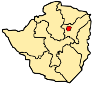
mapsize =150px
map_caption =Map of Zimbabwe showing the location of Harare.
mapsize1 =
map_caption1 =
image_dot_
dot_mapsize =
dot_map_caption =
dot_x = |dot_y =
subdivision_type =Country
subdivision_name =Zimbabwe
subdivision_type1 =Province
subdivision_name1 =Harare
subdivision_type2 =
subdivision_name2 =
subdivision_type3 =
subdivision_name3 =
subdivision_type4 =
subdivision_name4 =
government_footnotes =
government_type =
leader_title =Mayor
leader_name =Muchadeyi Masunda
leader_title1 =
leader_name1 =
leader_title2 =
leader_name2 =
leader_title3 =
leader_name3 =
leader_title4 =
leader_name4 =
established_title =Founded
established_date =1890
established_title2 =
established_date2 =
established_title3 =Incorporated (city)
established_date3 =1935
area_magnitude =
unit_pref =
area_footnotes =
area_total_km2 =
area_land_km2 =
area_water_km2 =
area_total_sq_mi =
area_land_sq_mi =
area_water_sq_mi =
area_water_percent =
area_urban_km2 =
area_urban_sq_mi =
area_metro_km2 =
area_metro_sq_mi =
area_blank1_title =
area_blank1_km2 =
area_blank1_sq_mi =
population_as_of =2006
population_footnotes =
population_note =estimated
population_total =1600000
population_density_km2 =
population_density_sq_mi =
population_metro =
population_density_metro_km2 =
population_density_metro_sq_mi =
population_urban =2800111
population_density_urban_km2 =
population_density_urban_sq_mi =
population_blank1_title =
population_blank1 =
population_density_blank1_km2 =
population_density_blank1_sq_mi=
timezone=CAT
utc_offset=+2
timezone_DST=CEST
utc_offset_DST=+1
latd= 17|latm=51 |lats=50|latNS=S
longd= 31|longm= 1|longs=47|longEW=E
elevation_footnotes = [ Google Earth ]
elevation_m =1490
elevation_ft =
postal_code_type =
postal_code =
area_code =
twin1 =Nottingham
twin1_country =United Kingdom
twin2 =Munich
twin2_country =Germany
twin3 =Cincinnati
twin3_country =United States
twin4 =Prato
twin4_country =Italy
twin5 =Lago
twin5_country =Italy
twin6 =
twin6_country =
twin7 =
twin7_country =
blank_name =
blank_info =
blank1_name =
blank1_info =
blank2_name =
blank2_info =
blank3_name =
blank3_info =
blank4_name =
blank4_info =
blank5_name =
blank5_info =
website =http://www.hararecity.co.zw
footnotes =


Harare is the site of the
History
The name of the city was changed to Harare on
The area at the time of founding of the city was poorly drained and earliest development was on sloping ground along the left bank of a stream that is now the course of a trunk road (Julius Nyerere Way). The first area to be fully drained was near the head of the stream and was named Causeway as a result. This area is now the site of many of the most important Government buildings, including the Senate House and the Office of the Prime Minister (now renamed for the use of President Mugabe after the position was abolished in January 1988.) [Journal of Frederick Courtney Selous, Rhodesiana Reprint Library, Salisbury, 1969]
Climate
Harare has a pleasant and healthy climate. The average annual temperature is 17.95°C, rather low for the tropics, and this is due to its high altitude position and the prevalence of a cool south-easterly airflow. [Average for years 1965-1995, Goddard Institute of Space Studies World Climate database] There are three main seasons - a warm, wet season from November to March/April; a cool, dry season from May to August (corresponding to the Southern Hemisphere winter); and a hot, dry season in September/October. Daily temperature ranges are about 7°C to 20°C in July (coldest month), about 13°C to 28°C in October (hottest month) and about 15.5°C to 25°C in January (midsummer). The hottest year on record was 1914 - 19.73°C - and the coldest year was 1965 - 17.13°C.The average annual rainfall is about 825mm in the south-west rising to 855mm on the higher land in the north-east (around Borrowdale to Glen Lorne). Very little rain usually falls during the period May to September although sporadic showers occur in most years. Rainfall varies a great deal from year to year and follows cycles of wet and dry periods that are from 7 to 10 years long. Records begin in October 1890 but all three Harare stations stopped reporting in early 2004. [Global Historic Climate Network database NGDC]
The climate supports a natural vegetation of open woodland. The most common tree of the local region is the Msasa
uburbs
These are some of the suburbs of Harare.
Notable landmarks and institutions
*
*
*
*
*
*
*
*
*
*
*
*
*
*
*
*
*
*
*
*
*
International Venue
Harare has been the location of several international summits such as the 8th Summit of the Non-Aligned Movement (
Transport
The public transport system of buses, run by
News & information
Residents are exposed to a variety of sources for information, though almost all of their sources are controlled by the government. In the print media, there is the
Recent developments
In the early 21st century Harare has been adversely affected by the political and economic crisis that is currently plaguing Zimbabwe, after the contested 2002 presidential election and 2005 parliamentary elections. The elected council was replaced by a government-appointed commission for alleged inefficiency, but essential services such as rubbish collection and street repairs have rapidly worsened, and are now virtually non-existent. In May 2006 the Zimbabwean newspaper the "
In May 2005 the Zimbabwean government demolished
This was followed by
ister cities
*flagicon|United Kingdom
*flagicon|Germany
*flagicon|United States
*flagicon|Italy
*flagicon|Italy Lago,
Image gallery
ee also
*
*
*
*
References
External links
* [http://www.hararecity.co.zw Official website]
Wikimedia Foundation. 2010.