- River Biss
Geobox River
name = River Biss
native_name =
other_name =
other_name1 =
image_size = 200
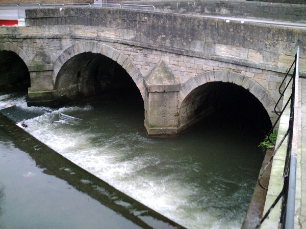
image_caption = The River Biss flowing under the town bridge inTrowbridge
country =United Kingdom
country1 =
state =
state1 =
region =Wiltshire
region1 =
district =
district1 =
city =
city1 =
length = 18.385
watershed =
discharge_location =Staverton, Wiltshire
discharge_average =
discharge_max =
discharge_min =
discharge1_location =
discharge1_average =
source_name =
source_location = nearUpton Scudamore ,Wiltshire
source_district =
source_region =
source_state =
source_country =
source_lat_d =51
source_lat_m =13
source_lat_s =42
source_lat_NS =N
source_long_d =2
source_long_m =11
source_long_s =40
source_long_EW =W
source_elevation =
source_length =
mouth_name =
mouth_location = Staverton,Wiltshire
mouth_district =
mouth_region =
mouth_state =
mouth_country =
mouth_lat_d =51
mouth_lat_m =20
mouth_lat_s =22
mouth_lat_NS =N
mouth_long_d =2
mouth_long_m =12
mouth_long_s =24
mouth_long_EW =W
mouth_elevation =
tributary_left =
tributary_left1 =
tributary_left2 =
tributary_left3 =
tributary_right =
tributary_right1 =
free_name =
free_value =
map_size =
map_caption =The River Biss is a small river inWiltshire, England and is a tributary of the Avon. The name is of uncertain origin; it is claimed that the word is from theOld Norse "bisa", meaning "to strive". [cite book
last = Longstaff
first = John C.
authorlink =
coauthors =
title = Notes on Wiltshire Names
publisher = Library Press
date = 1911
location =Bradford on Avon
pages = 127
url =
doi =
id =
isbn = ]Progress
The Biss rises as the Biss Brook [cite web|url=http://www.british-history.ac.uk/report.aspx?compid=16095&strquery=biss|title=Biss Brook] near
Upton Scudamore [cite web|url=http://www.kc3.co.uk/~micronic/uptnscud.htm|title=Source] on the western side ofSalisbury Plain ,and flows northwards passing Westbury towardsTrowbridge .The Baptist church at
North Bradley lies close to the River Biss and in the 19th century river baptisms took place with over 2000 in attendance; the bridge here is still called 'The Baptising'. [ [http://www.wiltshire.gov.uk/community/getchurch.php?id=757 Baptist church] ]The river enters the centre of Trowbridge from the southeast through the "Biss Meadows Country Park", where local wildlife can be seen. [cite web|url=http://www.westwiltshire.gov.uk/index/leisure/parks_and_recreation/country-pks-nature-reserves/biss-meadows.htm|title=Biss Meadows] It then flows through the "Town Park", where a small constituent lake is haunt to wildfowl, before passing behind shops and industrial buildings in a "Riverside Walk" which was opened in 1993 by the Duke of Edinburgh. [Trowbridge Town Council & Environment Agency information board at Trowbridge Library] The walk is now largely an overgrown
tarmac path for which improvements have been suggested. [cite web|url=http://www.westwiltshire.gov.uk/trowtown-cons-area-assmt-section5.8.pdf|title=Riverside Walk Assessment|format=PDF] In November 2007, theDistrict Council announced a study into implementing those improvements. [cite web|url=http://www.westwiltshire.gov.uk/index/news/news-article.htm?newsid=28205|title=Riverside Walk Improvements] Before leaving the centre of Trowbridge, the Biss flows under the Town Bridge in roughly the location of the original river crossing which gives the town its name; in this area the river is home to a species of yellow water lily known as "Brandy Bottle" after the shape of its fruit and its characteristic scent.Although Trowbridge is a former woollen cloth manufacturing town, for which a supply of water is required, the Biss was never substantial enough to satisfy the demands of that industry. [cite web|url=http://www.wiltshire.gov.uk/community/getcom.php?id=228|title=Use in Industry] However, there was an attempt to supply the town; the Trowbridge Water Company was formed and piped water was turned on in the town on
30 September 1874 . Supplies were inadequate, however, and the venture failed. [cite web|url=http://www.wiltshire.gov.uk/community/getfaq.php?id=128|title=Trowbridge Water Company] The company had premises in "Waterworks Road", now a residential area.On leaving the town centre, the Biss continues northwards through the Ladydown area towards
Bradford on Avon , where it is a popular venue for canoeists. [cite web|url=http://www.ukriversguidebook.co.uk/biss.htm|title=Canoeing] It is crossed by theKennet and Avon Canal at the "Biss Aqueduct" before flowing into the River Avon inWidbrook Wood , south of Staverton. Here,narrowboat s are made available for hire. [cite web|url=http://www.jim-shead.com/waterways/More-than-a-Mooring---Hilperton-Marina.html|title=Staverton Marina]Notes
References
*"Trowbridge Nature Trail", leaflet published jointly by West Wiltshire District Council and the [http://www.trowbridgecivicsociety.org.uk/ Trowbridge Civic Society] .
Wikimedia Foundation. 2010.