- Swaffham Bulbeck
-
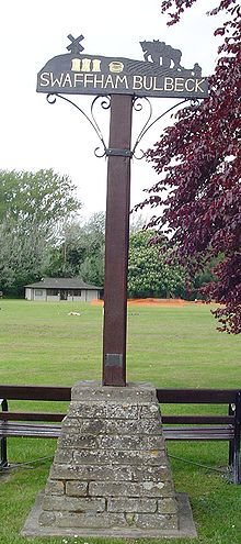 Signpost in Swaffham Bulbeck
Coordinates: 52°14′N 0°17′E / 52.23°N 0.28°E
Swaffham Bulbeck 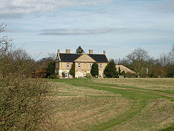
The Old Abbey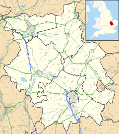
 Swaffham Bulbeck
Swaffham Bulbeck shown within CambridgeshireOS grid reference TL559619 District East Cambridgeshire Shire county Cambridgeshire Region East Country England Sovereign state United Kingdom Post town CAMBRIDGE Postcode district CB5 Dialling code 01223 EU Parliament East of England List of places: UK • England • Cambridgeshire Swaffham Bulbeck is a village in East Cambridgeshire, England.
Swaffham Bulbeck is located about 8 miles (13 km) from the city of Cambridge, and 6 miles (10 km) from the famous racing town of Newmarket. The parish of Swaffham Bulbeck is part of the Diocese of Ely and the Deanery of Fordham and Quy. The benefice consists of five parishes, Swaffham Bulbeck, Swaffham Prior, Bottisham, Lode and Quy.
Children initially attend primary school in the village and usually then go on to Bottisham Village College.
Contents
Culture and community
Every year the village summer theatre company produces and performs one of Gilbert and Sullivan's operas. Established in 1982 the company has run every year since, first at the Long Barn to the south of the village until its redevelopment in 1988 and then to a much more capacious setting in a barn central to the village by kind permission of the owner. This venue too has now come up for redevelopment and the production is now based at Downing Farm by kind permission of the Turner family.
Church
The church is dedicated to St Mary the Virgin. The west tower was built in the early 13th century and is the most ancient part of a very ancient building. The tower is 12.5 feet (4 m) square with three storeys and is supported by eight buttresses. It is built of locally quarried clunch (from Burwell).
The nave was constructed in the first half of the 13th century. It consists of four uniform bays with six octagonal piers supporting the clerestory which was added in the 15th century. The north aisle was built in about 1300 and the south aisle a few years later.
Apart from some fragments of 14th and 15th century stained glass in the north aisle, all the 10 windows in the aisles and 8 in the celestorey are of plain leaded glass. The nave is some 57 feet (17 m) long by 21 feet (6 m) wide and the aisles are 11 feet (3 m) wide. The church can seat about 200 people at full capacity.
The churchyard contains many interesting gravestones — there are six tomb chests, the earliest dating from 1742, and about 35 headstones with shaped tops dating from 1703 onwards.
As regards the vicarage, in the late 1970s it was decided by the parish that the village no longer required a vicarage of its own. It was sold to the public, and now provides bed and breakfast accommodation. It is erroneously now called The Old Rectory.
Trade
The village is located just beyond the end of Swaffham Bulbeck Lode, a man-made waterway which connects with the River Cam. The Hamlet of Commercial End, at the northern edge of the village, was an important inland port from medieval times, although the waterway had been in use since Roman times.[1] Principal buildings include the late 17th century Merchants House, which had a counting house added in the mid 18th century. Workers' cottages and warehouses were added to the street by Thomas Bowyer, after he acquired the house in 1805. River trade declined once the railways reached the area, and the house and contents were sold after 1877. The street retains its 18th and early 19th century character, although the lode is now only navigable as far as Slade Farm, some 2 miles (3.2 km) away.[2]
Notable citizens
Swaffam Bulbeck is the residence of the twice Nobel prize winner Frederick Sanger.
Swaffham Bulbeck was the residence of the Lyell Medal winner and world renowned angler Barrie Rickards.
Swaffam Bulbeck was the residence of Sir Bryan Harold Cabot Matthews CBE FRS. He was Professor of Physiology at Kings College, Cambridge 1952 - 1973 and lived in the Grade II listed Priest's House at 99 High Street.
References
- ^ The River Great Ouse and tributaries, (2006), Andrew Hunter Blair, Imray Laurie Norie and Wilson, ISBN 978-0-85288-943-5
- ^ The Canals of Eastern England, (1977), John Boyes and Ronald Russell, David and Charles, ISBN 978-0715374153
External links
- http://www.swaffhambulbeckpc.org.uk/
- http://www.genuki.org.uk/big/eng/CAM/SwaffhamBulbeck/index.html
- http://www.british-history.ac.uk/report.aspx?compid=18870e
- http://www.sbstgands.co.uk/
Cities 
Towns Villages Aldreth • Ashley • Barway • Bottisham • Brinkley • Burwell • Chettisham • Cheveley • Chippenham • Coveney • Dullingham • Fordham • Haddenham • Isleham • Little Downham • Little Thetford • Littleport • Lode • Longmeadow • Mepal • Prickwillow • Pymoor • Queen Adelaide • Reach • Stetchworth • Stretham • Stuntney • Sutton • Swaffham Bulbeck • Swaffham Prior • Upware • Wicken • Wilburton • Witcham • Witchford • WooddittonCivil Parishes Categories:- Villages in Cambridgeshire
- Civil parishes in Cambridgeshire


Wikimedia Foundation. 2010.