- Geelong
-
This article is about the Victorian city; the name may also refer to City of Geelong or Geelong city centre.
Geelong
Victoria
Geelong CBD and Corio Bay from North Shore in 2010.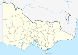
 Geelong
Population: 160,991 (2006 Census)[1] (12th) • Density: 165.3/km² (428.1/sq mi) Established: 1836 Postcode: 3220 Coordinates: 38°09′S 144°21′E / 38.15°S 144.35°ECoordinates: 38°09′S 144°21′E / 38.15°S 144.35°E Area: 1240 km² (478.8 sq mi) Time zone: • Summer (DST)
AEST (UTC+10) AEDT (UTC+11)
Location: 72 km (45 mi) SW of Melbourne LGA: City of Greater Geelong County: Grant State District: Federal Division: Mean max temp Mean min temp Annual rainfall 19.6 °C
67 °F9.4 °C
49 °F552.7 mm
21.8 inGeelong (
 /dʒəˈlɒŋ/)[2][3] is a port city located on Corio Bay and the Barwon River, in the state of Victoria, Australia, 75 kilometres (47 mi) south-west of the state capital; Melbourne. It is the second most populated city in Victoria and the fifth most populated non-capital city in Australia. The urban area runs from the plains of Lara in the north to the rolling hills of Waurn Ponds to the south, with the bay to the east and hills to the west, an area with an estimated population of 160,991 people.[1] It is the administrative centre for the City of Greater Geelong municipality which covers the urban and surrounding areas and is home to over 191,000 people. An inhabitant of Geelong has been known as a Geelongite,[4] or a Pivotonian, in the past.
Geelong was named in 1837 by Governor Richard Burke, with the name derived from the local Wathaurong Aboriginal name for the region, Jillong, thought to mean 'land' or 'cliffs'.[5] The area was first surveyed in 1838, three weeks after Melbourne, and the Post Office was open by June 1840 (the second to open in the Port Phillip District).[6] The first woolstore was erected in this period and it became the port for the wool industry of the Western District.[7] During the gold rush Geelong experienced a brief boom as the main port to the rich goldfields of the Ballarat district.[8] The city then diversified into manufacturing and during the 1860s it became one of the largest manufacturing centres in Australia with its wool mills, ropeworks, and paper mills.[9]
It was proclaimed a city in 1910, with industrial growth from this time until the 1960s establishing the city as a manufacturing centre for the state,[7] and saw the population grow to over 100,000 by the mid 1960s.[10] Population increases over the last decade were due to growth in service industries,[11] as the manufacturing sector has declined. Redevelopment of the inner city has occurred since the 1990s, as well as gentrification of inner suburbs and currently has a population growth rate higher than the national average.[12]
It is known for being home to car manufacturer Ford Australia and also the Geelong Football Club, nicknamed The Cats.
Contents
History
Main article: History of GeelongSee also: Visitor attractions in Geelong, Victorian gold rush, Category:Suburbs of Geelong, and Category:Visitor attractions in GeelongEarly history and foundation
The area of Geelong and the Bellarine Peninsula was originally occupied by the Wathaurong Indigenous Australian tribe.[13]
The first non-Aboriginal person recorded as visiting the region was Lt. John Murray, who commanded the brig Lady Nelson.[8] After anchoring outside Port Phillip Heads (the narrow entrance to Port Phillip, onto which both Geelong and Melbourne now front) on 1 February 1802 he sent a small boat with six men to explore.[14] Led by John Bowen they explored the immediate area, returning to the Lady Nelson on 4 February. On reporting favourable findings, the Lady Nelson entered Port Phillip on 14 February, and did not leave until 12 March. During this time, Murray explored the Geelong area and, whilst on the far side of the bay, claimed the entire area for Britain. He named the bay Port King, after Philip Gidley King,[14] then Governor of New South Wales. Governor King later renamed the bay Port Phillip after the first governor of New South Wales, Arthur Phillip.[15] Arriving not long after Murray was Matthew Flinders, who entered Port Phillip on 27 April 1802.[8] He charted the entire bay, including the Geelong area, believing he was the first to sight the huge expanse of water, but in a rush to reach Sydney before winter set in he left Port Phillip on 3 May.
In January 1803, Surveyor-General Charles Grimes arrived at Port Phillip in the sloop Cumberland and mapped the area, including the future site of Geelong,[14] but reported the area was unfavourable for settlement and returned to Sydney on 27 February.[16] In October of the same year, the HMS Calcutta led by Lieutenant-Colonel David Collins arrived in the bay to establish the Sullivan Bay penal colony.[14] Collins was dissatisfied with the area chosen, and sent a small party led by First Lieutenant J.H. Tuckey to investigate alternate sites.[17] The party spent 22 October to 27 October on the north shore of Corio Bay, where the first Aboriginal death at the hands of a European in Victoria occurred.[14]
The next European visit to the area was by the explorers Hamilton Hume and William Hovell. They reached the northern edge of Corio Bay - the area of Port Phillip that Geelong now fronts - on 16 December 1824,[18] and it was at this time they reported that the Aborigines called the area Corayo, the bay being called Jillong.[8] Hume and Hovell had been contracted to travel overland from Sydney to Port Phillip, and having achieved this they stayed the night and begun their return journey two days later on 18 December.[18]
The convict William Buckley escaped from the Sullivan Bay settlement in 1803, and lived among the Wathaurong people for 32 years on the Bellarine Peninsula.[19] In 1835, John Batman used Indented Head as his base camp,[20] leaving behind several employees whilst he returned to Tasmania (then known as Van Diemen's Land) for more supplies and his family. In this same year, Buckley surrendered to the party led by John Helder Wedge and was later pardoned by Lieutenant-Governor Sir George Arthur, and subsequently given the position of interpreter to the natives.[21]
 Depiction of early Geelong as a small collection of houses and paddocks by the bay.
In March 1836, three squatters, David Fisher, James Strachan and George Russell arrived on the Caledonia and settled the area.[14] Geelong was first surveyed by Assistant Surveyor, W. H. Smythe three weeks after Melbourne, and was gazetted as a town on 10 October 1838.[8] There was already a church, hotel, store and wool store, 82 houses, and the town population was 545.[8] By 1840, the first wool had been sent to England and a regular steamer service was running between Geelong and Melbourne.[20] Captain Foster Fyans was commissioned as the local Police Magistrate in 1837 and established himself on the Barwon River at the site of the area of present-day Fyansford.[22] Fyans constructed a breakwater to improve the water supply to the city by preventing the salty lower reaches from mixing with fresh water and pooling water.
The Geelong Keys were discovered around 1845 by Governor Charles La Trobe on Corio Bay. They were embedded in the stone in such a way that he believed that they had been there for 100–150 years, possibly dropped by Portuguese explorers.[23] In 1849, Fyans was nominated as the inaugural Mayor of the Geelong Town Council.[22] An early settler of Geelong, Alexander Thomson, for which the area of Thomson in East Geelong is named, settled on the Barwon River, and was Mayor of Geelong on five occasions from 1850–1858.[24]
1850s: Gold rush

 A paddlesteamer approaches busy Geelong Harbour in 1857
Gold was discovered in nearby Ballarat in 1851, causing the Geelong population to grow to 23,000 people by the mid 1850s.[8] To counter this, a false map was issued by Melbourne interests to new arrivals, showing the quickest road to the goldfields as being via Melbourne.[8] The first issue of the Geelong Advertiser newspaper was published in 1840 by James Harrison, who also built the world's first Ether Vapour Compression Cycle ice making and refrigeration machine in 1844, later being commissioned by a brewery in 1856 to build a machine that cooled beer.[25]
The Geelong Hospital was opened in 1852, and construction on the Geelong Town Hall commenced in 1855.[10] Development of the Port of Geelong began with the creation of the first shipping channel in Corio Bay in 1853.[10] The Geelong to Melbourne railway was built by the Geelong and Melbourne Railway Company in 1857 [26] Rabbits were introduced to Australia in 1859 by Thomas Austin, who imported them from England for hunting purposes at his Barwon Park property near Winchelsea.[27] One of Geelong's best known department stores, Bright and Hitchcocks, was opened in 1861,[10] and the HM Prison Geelong built using convict labour, was opened in 1864.[28]
In 1866 Graham Berry started a newspaper, the Geelong Register, as a rival to the established Geelong Advertiser. When this proved unsuccessful, he bought the Advertiser and made himself editor of the now merged papers.[29] Using the paper as a platform, he was elected for West Geelong in 1869. In 1877 he switched to Geelong, which he represented until 1886, and served as Victorian Premier in 1875, 1877–1880, and 1880–1881.[30] On the Market Square in the middle of the city, a clock tower was erected in 1856,[31] and an Exhibition Building was opened in 1879, ahead of Melbourne.
1860s: The 'Sleepy Hollow'
 Exhibition Building and Market Square Clocktower in 1879. (both since demolished)
The gold rush had seen Ballarat and Bendigo grow larger than Geelong in terms of population. Melbourne critics dubbed Geelong 'Sleepy Hollow',[8] a tag that recurred many times in the following years. A number of industries became established in Geelong, including Victoria's first woollen mill at South Geelong in 1868. In 1869 the clipper Lightning caught fire at the Yarra Street pier and was cast adrift in Corio Bay to burn before finally sunk by artillery fire.[20] Improvements to transport saw Geelong emerge as the centre of the Western District of Victoria, with railway lines extended towards Colac in 1876, and to Queenscliff in 1879.[26] Construction of the Hopetoun shipping channel began in 1881 and completed in 1893.[10]
The Geelong Cup was first held in 1872 and Victoria's first long distance telephone call was made from Geelong to Queenscliff on 8 January 1878, only one year after the invention of the device itself.[10] Geelong was also the home of a prosperous wine industry until the emergence of the grapevine eating insect phylloxera vastatrix in 1885, which killed the industry until the 1960s.[10] Between 1886 and 1889 the central business district's major banks and insurance companies erected new premises in a solid and ornate character.[8] The existing Geelong Post Office was built during this time and the Gordon Technical College was established. Further industrial growth occurred with the Fyansford cement works established in 1890.[32]
The town became known as 'the Pivot' in the 1860s owing to its being a central rail and shipping hub to Melbourne, Ballarat and the western district.[33]
1900s: A city develops
 Opening of the Geelong tramway in 1912, Moorabool St, Geelong.
The town of Geelong officially became a city on 8 December 1910. The city gained a number of essential services, with electric light supplied by the Geelong Power Station starting in 1902, the Geelong Harbour Trust was formed in December 1905,[34] and the Geelong Waterworks and Sewerage Trust formed in 1908. Electric trams began operation in 1912, travelling from the city centre to the suburbs until their demise in 1956.[35] The first of many stores on the Market Square was opened in 1913,[10] and the first Gala Day festival was held in 1916.[10]
Geelong's industrial growth accelerated in the 1920s: woollen mills, fertiliser plants, the Ford Motor Company's vehicle plant at Norlane, and the Corio whiskey distillery were all established in this period.[26] The Geelong Advertiser's radio station 3GL (now K-Rock) commenced transmission in 1930,[20] the Great Ocean Road was opened in 1932, and the T & G Building in 1934.
By 1936 Geelong had displaced Ballarat as Victoria's second largest city.[36]
 The steamboat Edina leaving Geelong on its final journey on 21 June 1938.
In 1938 one of the last Port Philip Bay steamers, Edina, made its final trip to Geelong, ending a romantic period of seaside excursions and contests for the fastest trip. The Eastern Beach foreshore beautification and pool was completed in 1939 after almost 10 years of work.[10]
On the eve of World War II the International Harvester works were opened beside Ford at North Shore, a grain elevator at nearby Corio Quay, and the Shell Australia oil refinery.[26]
Post-war period
 Eastern Beach in 1950
Government housing was constructed in the suburbs of East Geelong, Norlane, North Shore and Corio from the 1950s to provide accommodation for the growing workforce. The banks of the Barwon River burst in 1952, flooding nearby Belmont Common.
Geelong continued to expand with Corio, Highton and Belmont growing at such a rate that in February 1967 Geelong accounted for 21 per cent of private home development in non-metropolitan Victoria.[8] Private vehicles became the city's major mode of transport. The first parking meters in the city were introduced in 1961, new petrol stations were constructed and the city's first supermarket, operated by Coles, opened in 1965.[8] Industrial growth continued with a second cement works operating at Waurn Ponds by 1964[26] and the Alcoa Point Henry aluminium smelter constructed in 1962.[37]
Federal Government policy changes on tariff protection led to the closure of many Geelong industrial businesses from the 1970s. The woollen mills closed in 1974 and hectares of warehouse space in the city centre were left empty after wool handling practices changed.[8] The Target head office opened in North Geelong, Deakin University was established at Waurn Ponds in 1974 and the Geelong Performing Arts Centre opened in 1981.[38] Later, the Australian Animal Health Laboratory was opened in 1985,[39] and the National Wool Museum in 1988.[40]
Market Square, the first enclosed shopping centre in the city was opened in 1985, with neighbouring Westfield Geelong (formerly Bay City Plaza) opened in 1988.[41] The Pyramid Building Society, founded in Geelong in 1959,[42] collapsed in 1990 leaving debts of A$1.3 billion to over 200,000 depositors,[43] and causing the Geelong economy to stagnate.[44] On 18 May 1993 the City of Greater Geelong was formed by the amalgamation of a number of smaller municipalities with the former City of Geelong.[45] The Waterfront Geelong redevelopment started in 1994 designed to enhance use and appreciation of Corio Bay[46] and in 1995 the Barwon River overflowed in the worst flood since 1952.[47]
21st century
 Westfield Geelong construction works in 2007
 Redeveloped Waterfront Geelong (Steampacket Quay)
In 2004, Avalon Airport was upgraded to provide for interstate passenger travel, providing a base for the low-cost airline Jetstar to service the Melbourne and Geelong urban areas.[48] Geelong expanded towards the coast with Mount Duneed becoming a residential area and plans for a new neighborhood known as Armstrong Creek were developed by City of Greater Geelong.[49] Construction begun on the Geelong Ring Road in 2006. The ring road is designed to replace the Princes Highway through Geelong from Corio to Waurn Ponds and opened in 2009.
More than A$500 million worth of major construction was under way in 2007.[50] Major projects include the $150 million Westfield Geelong expansion works, involving a flyover of Yarra Street, the city's first Big W store and an additional 70 new speciality stores; the $37 million Deakin Waterfront campus redevelopment and the $23 million Deakin Medical School; the $50 million Edgewater apartment development on the waterfront; a number of multi-million dollar office developments in the CBD; and a new $30 million aquatic centre in Waurn Ponds.[50]
Major developments within Geelong are advocated by the region's formal alliance, G21 Geelong Region Alliance. The City of Greater Geelong and four other local municipalities form part of the alliance which identifies the Geelong region's priorities, advocate all levels of government for funding and implement the projects. G21 developed 'The Geelong Region Plan - a sustainable growth strategy' which was launched by Premier Brumby in 2007. It is the approved strategic plan for the Geelong region. In addition, major projects such as the Geelong Ring Road Connections, Duplication of the Princes Highway West have obtained funding due to the combined efforts of the region's municipalities. As at November 2011, there are 13 Priority Projects for the Geelong region.
The Victorian Government announced the relocation of the Transport Accident Commission headquarters from Melbourne to Geelong in October 2006, which created 850 jobs and an annual economic benefit of over $59 million to the Geelong region.[51] The construction of the $80 million Brougham Street headquarters was completed in late 2008.[52] In November 2008 Ford Australia announced that its Australian designed I6 engine would be re-engineered to meet the latest emissions regulations and that consequently the engine manufacturing plant would be upgraded.
A change to the city skyline is occurring with a growing number of modern apartment towers on the Waterfront and central business district planned or under construction. On 10 July 2008 approval was given for a $100 million twin tower apartment complex of 16 and 12 floors to be built on Mercer St in the city's Western Wedge. The towers will become the tallest buildings in the city, taking the title from the Mercure Hotel.[53] Further highrise developments is planned as part of the City of Greater Geelong's Geelong Western Edge strategic plan.[54] A $17 million 11 level apartment tower has also recently been proposed to be built next to the Deakin Waterfront Campus.[55]
Geography
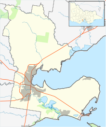 Map of the Geelong urban area and the City of Greater Geelong
Geelong is located on the shores of Corio Bay, a south-western inlet bay of Port Phillip. During clear weather, the Melbourne skyline is visible from areas of Geelong when viewed across Port Phillip. The Barwon River flows through the city to the south before entering Lake Connewarre and the Barwon River estuary at Barwon Heads before going into Bass Strait.[56]
Geologically the oldest rocks in the area date to the Cambrian period 500 million years ago, with volcanic activity occurring in the Devonian period 350 million years ago.[57] In prehistoric times water covered much of the lowlands that are now Geelong, with the Barwon River estuary located at Belmont Common, the course of the river being changed when Mount Moriac erupted and lava was sent eastwards towards Geelong.[56]
To the east of the city are the Bellarine Hills and the undulating plains of the Bellarine Peninsula. To the west are the sandstone derived Barrabool Hills and basalt Mount Duneed, and the volcanic plains to the north of Geelong extend to the Brisbane Ranges and the You Yangs.[57] Soils vary from sandy loam, basalt plains and river loam to rich volcanic soils,[58] suitable for intensive farming, grazing, forestry and vineyard plantation.
Many materials used to construct buildings were quarried from Geelong, such as bluestone from the You Yangs and sandstone from the Brisbane Ranges.[57] A small number of brown coal deposits exist in the Geelong region, most notably at Anglesea where it has mined to fuel Alcoa's Anglesea Power Station since 1969.[59] Limestone has also quarried for cement production at Fyansford since 1888,[32] and Waurn Ponds since 1964.[60]
City and suburbs
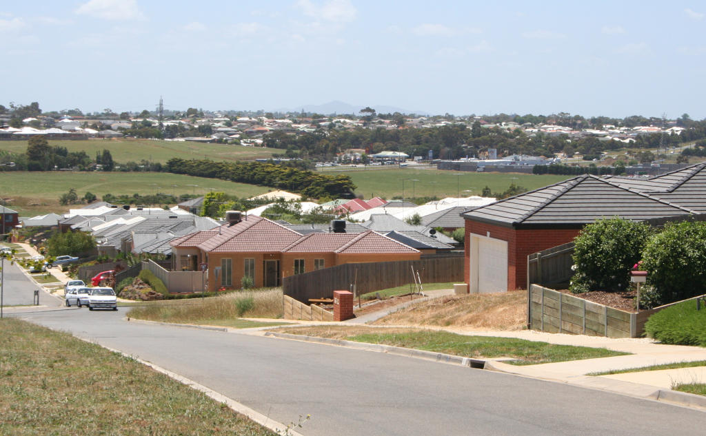
 Suburban expansion in Grovedale
Development in Geelong started on the shores of Corio Bay in what is now the inner city. Development later spread to the south towards the Barwon River, and the hill of Newtown and Geelong West. Major development south of the river in Belmont did not start until the 1920s, stimulated by the construction of a new bridge over the river in 1926, and the extension of the Geelong tramway system in 1927.[10] Industrial areas were traditionally located on the Corio Bay for port access,[61] or the Barwon River for waste disposal.
In the interwar and post World War II years heavy industry continued to establish itself in the flatter northern suburbs,[61] where today industries such as the Shell oil refinery and Ford Motor Company engine plant reside.[62] Residential development also spread to Corio in the north, with new Housing Commission of Victoria estates built to cater for employees of the new industries. From the 1960s residential growth spread to the Highton hills in the south, followed by Grovedale in the 1970s. A number of light industrial areas were also established in Breakwater, Moolap and South Geelong.[61]
Changing cargo handling methods at the Port of Geelong left woolstores in inner Geelong unused, redevelopment beginning in the 1980s with the expansion of Westfield Geelong towards Corio Bay, and culminating in the Waterfront Geelong development.[63] Gentrification of former working class inner suburbs such as Geelong West, North Geelong and South Geelong has also occurred.[64] Today the major residential growth corridors are north towards Lara, east towards Leopold, and south towards Mount Duneed as the Armstrong Creek Growth Area.[49]
Climate
Geelong has stable weather while still offering four distinct seasons.[65] It has a temperate climate with dominant westerly winds, variable cloud, moderate precipitation, warm summers and cool winters.[66][67] January is the hottest month, and July is the coldest.[68] The highest temperature recorded was 47.9 °C (120 °F) on 7 February 2009, with the lowest of −4.4 °C (24 °F) recorded on 5 August 1997.[69] The average annual rainfall is 536.4 millimetres (21.12 in).[68]
Climate data for Geelong Month Jan Feb Mar Apr May Jun Jul Aug Sep Oct Nov Dec Year Average high °C (°F) 24.4
(75.9)24.8
(76.6)23.1
(73.6)20.2
(68.4)17.1
(62.8)14.5
(58.1)13.9
(57.0)15.0
(59.0)16.6
(61.9)18.6
(65.5)20.5
(68.9)22.6
(72.7)19.3 Average low °C (°F) 12.9
(55.2)13.5
(56.3)12.0
(53.6)9.4
(48.9)7.8
(46.0)6.1
(43.0)5.4
(41.7)5.8
(42.4)6.6
(43.9)7.6
(45.7)9.4
(48.9)11.0
(51.8)9.0 Rainfall mm (inches) 34.0
(1.339)29.7
(1.169)30.2
(1.189)46.0
(1.811)47.3
(1.862)41.7
(1.642)50.3
(1.98)48.2
(1.898)49.5
(1.949)49.7
(1.957)51.4
(2.024)40.9
(1.61)518.9
(20.429)Avg. rainy days 4.1 3.1 4.5 6.0 7.0 7.9 10.0 9.5 9.6 8.2 6.2 5.4 81.5 Source: [70] Economy
 Westfield Bay City in 2006
More than 10,000 businesses employ over 80,000 people in the Geelong region,[11] with manufacturing and processing industries providing around 15,000 jobs, followed by 13,000 in retail, and 8,000 in health and community services.[11]
Geelong's major employers include the Ford Motor Company engine plant in Norlane, aircraft maintenance at Avalon Airport, the head office of retail chain Target, the Bartter (Steggles) chicken processing plant, Alcoa's Point Henry aluminium smelter, and the Shell oil refinery at Corio.[71]
The Geelong region attracted over 6,000,000 tourists during 2001.[72] Major tourist attractions include the Waterfront Geelong precinct and Eastern Beach on the shores of Corio Bay, the Ford Discovery Centre and National Wool Museum in the city, and more than 30 historical buildings listed on the Victorian Heritage Register.[73] The Geelong area hosts regular international events which are also tourist drawcards including the Australian International Airshow.
Geelong has a number of shopping precincts in the CBD and surrounding suburbs. The two main shopping centres are located in the CBD - Westfield Geelong and Market Square, with smaller centres in the suburbs including Belmont Plaza and Waurn Ponds Shopping Centre in the south, Bellarine Village in Newcomb in the east, and Corio Village Shopping Centre in the north.[11] The opening of the major shopping centres have seen a decline in strip shopping on Moorabool Street, with many empty shops and few customers.[74] Geelong is also home to Mitre 10's largest franchisees Fagg's operating five stores across the town and employing over 160 people.
Located in Geelong are major research laboratories, the CSIRO Australian Animal Health Laboratory in East Geelong, CSIRO Division of Textiles and Fibres Technology in Belmont and the Marine and Freshwater Resources Institute at Queenscliff.
Demographics
Population over time[10] 1841 454 1846 2,065 1851 8,291 1854 20,115 1861 22,929 1891 17,445 1901 25,017 1907 28,021 1921 31,689 1933 39,223 1946 51,000 1954 72,995 1961 91,666 1966 105,059 1976 122,080 1981 141,279 1988 146,349 2006 160,991 2009 179,971 2010 184,583 As of the 2006 Census, there were 160,000 people residing in 68,000 households. The median age of persons in Geelong was 37 years. 19.4% of the population of Geelong were children aged between 0–14 years, and 26.6% were persons aged 55 years and over.[1] Each dwelling is on average occupied by 2.59 persons, slightly lower than the state and national averages.[75] The median household income was $901 per week, $121 less than the state average, partly due to higher reliance on manufacturing for employment.[75] The population of Geelong is growing by 2500 people each year,[76] and the City of Greater Geelong had the highest rate of building activity in Victoria outside metropolitan Melbourne.[77]
78.4% of people from Geelong are Australian born, with the most common overseas birthplaces being: England (3.6%), Italy (1.1%), Croatia (1.0%), Netherlands (0.9%), Scotland (0.8%). 14.2% of households speak a language other than English in the home.[1] Notable ethnic groups in the city are the Croatian community, who first came to the city in the 1850s[78] and with migration since World War II are now the largest Croatian community in Australia,[79] and the German settlers who founded Germantown (now Grovedale) in 1849 to escape repression in Prussia for their Lutheran faith.[80]
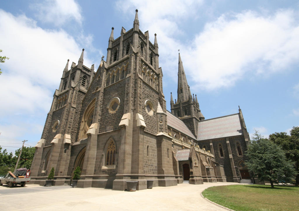
 St Mary of the Angels Basilica
The 2006 Census found the most common religious affiliations in Geelong were Catholicism at 29.4%. St Mary of the Angels Basilica is the largest congregation in the city. Other affiliations of resident of Geelong include No Religion 20.5%, Anglican 14.6%, Uniting Church 7.9% and Presbyterian and Reformed at 4.3%.[1] The city has a large number of traditional Christian churches, as well as Orthodox Christian churches in the northern suburbs.
Governance
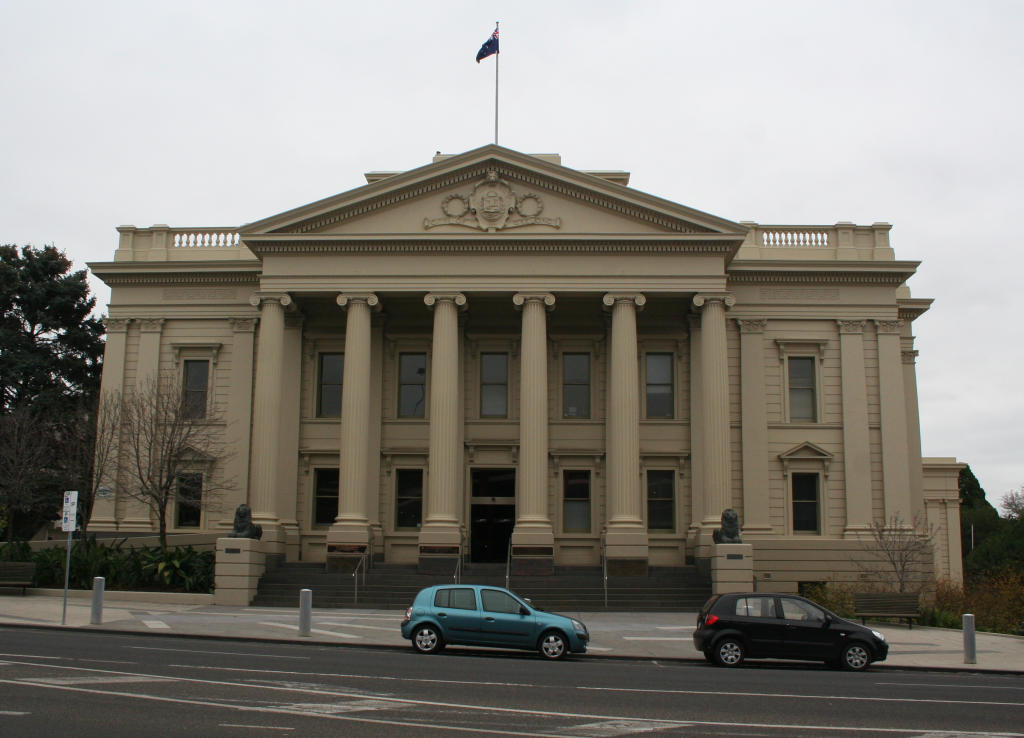
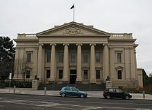 Geelong Town Hall
In local government, the Geelong region is covered by the City of Greater Geelong. The council was created in 1993 as an amalgamation of a number of other municipalities in the region,[45] with the council chambers located at the Geelong Town Hall in central Geelong. The City is made up of 12 wards, each represented by a councillor elected once every four years by postal voting.[81] The Mayor of Geelong is elected from these councillors by their colleagues for a one year term.[81]
In state politics, Geelong is located in the Legislative Assembly districts of Geelong, South Barwon, Lara, and Bellarine, with all seats with the exception of South Barwon currently held by the Australian Labor Party.[82]
In federal politics, Geelong is located in two House of Representatives divisions - the Division of Corio to the north of the Barwon River, and the Division of Corangamite to the south. The Division of Corio has been a safe Australian Labor Party since the 1970s, and was the seat of Richard Casey, a leading Cabinet member in the 1930s and later Governor-General, and Gordon Scholes, who was Speaker during the Whitlam government.[83] The Division of Corangamite had been a safe seat for the Liberal Party since the 1940s, and was the seat of the ninth Prime Minister of Australia James Scullin.[84] It was reclaimed by the Australian Labor Party for the first time since 1931 at the 2007 federal election.[85]
Culture
Events and Festivals
The Royal Geelong Show is held each year at the Geelong Showgrounds.
Other smaller events include Pako Festival, Gala Day Parade and Family Fun Day and the Geelong Heritage Festival run by the local branch of the National Trust.
Geelong also hosts an international photographic salon every two years. Vigex was first held in 1980.
Arts and entertainment
 Geelong Performing Centre (Little Malop Street entry)
Geelong is home to a number of pubs, nightclubs and live music venues and has also given birth to a number of notable Australian bands and musicians such as Barry Crocker,[86] Gyan Evans,[87] Magic Dirt,[88] Jeff Lang,[89] and Denis Walter.[90] Geelong also hosts festivals such as the Queenscliff Music Festival, Meredith Music Festival, the Offshore Festival, Poppykettle Festival and Pako Festa, and has a number of cultural venues, including the Geelong Performing Arts Centre (commonly known as GPAC),[91] the 1500 seat Costa Hall auditorium, and the Geelong Art Gallery.[92]
Media
The Geelong Advertiser, the oldest newspaper title in Victoria and the second oldest in Australia,[93][94] was established in 1840. Also circulated are the free Geelong Independent, and Geelong News newspapers.
Geelong receives free to air television broadcasts from Melbourne, including community channel Channel 31. the channel carries the ABC, SBS, Seven Network, Nine Network & Network Ten. The Geelong region also receives cable and satellite television service through Pay-TV operators Foxtel & Neighbourhood Cable.
The local radio stations are K-Rock (rock & pop music station), Rhema FM (Christian community station), Hot Country Radio (country music station), The Pulse (community radio service), 3GPH (radio reading service), and Bay FM (adult contemporary). Transmitters for K-Rock, The Pulse, Rhema FM & Bay FM are located at a shared transmitter site on Mt Bellarine near Drysdale. Most radio stations from Melbourne can also be received clearly in Geelong and the surrounding region.
In popular culture
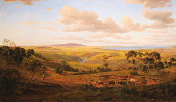
Geelong has inspired many[who?]visual artists, with several celebrated works depicting the city including Eugene von Guerard who depicted early Geelong in sketches and oil paintings including View of Geelong.
Geelong is a popular filming location. The Geelong region was used as the setting of the SeaChange television series, filmed on location at Barwon Heads between 1998 and 2002.[95] The city has also been the filming location of a number of feature films; including the final scenes On the Beach (1959) at Barwon Heads,[96] Mad Max (1979) around Lovely Banks and Lara, Everynight ... Everynight (1994) at HM Prison Geelong, Ned Kelly (2003) and Ghost Rider (2007) at the Little River Earth Sanctuary,[97] December Boys (2007) in South Geelong at Kardinia Pool,[98] and Knowing (2008) on the Geelong Ring Road.[99]
Two ships of the Royal Australian Navy (RAN) have been named after Geelong, HMAS Geelong (J201) and HMAS Geelong (FCPB 215).
Education
Main article: List of schools in Geelong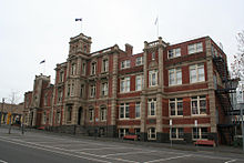 The Gordon Institute of TAFE building in Fenwick Street.
Geelong is served by a number of public and private schools that cater to local and overseas students. Over 40,000 primary and secondary students are enrolled in schools in Geelong, with another 27,000 students enrolled in tertiary and further education courses.[11] The first schools in Geelong were established when the town was settled from the 1850s, among them were the elite private schools The Geelong College and Geelong Grammar School.[71]
The Gordon Memorial Technical College opened in 1888, and is known today as the Gordon Institute of TAFE.[10] In 1976 the Gordon Institute was divided into two parts, with academic courses becoming part of the newly formed Deakin University based at the Waurn Ponds campus.[100] Deakin University enrolled its first students at its Waurn Ponds campus in 1977. Today the university is located on a 365 hectare site and has over 1,000 staff and over 4,000 on-campus students.[101] The university also has a campus located on the waterfront of Corio Bay in the Geelong CBD, and from 2008 the campus at Waurn Ponds will be home to Victoria's first regional medical school.[102]
Infrastructure
Health
 Main entrance to Geelong Hospital
The major public hospital is Geelong Hospital on Ryrie Street which services the entire region and the largest private hospital is the nearby St John of God Health Care centre on Myers Street. Prominent healthcare services include Geelong Health (Geelong West) and Barwon Health.
Utilities
 The former Geelong A power station, now part of Westfield Geelong
Water storage and supply in Geelong is managed by Barwon Water, a Victorian Government owned urban water corporation. Geelong is supplied with water from three river systems: the Barwon River, the East Moorabool River and the West Moorabool River. The catchment areas are the Brisbane Ranges to Geelong's north-west, and the Otway Ranges to the south-west. The first water supplies to Geelong were from the Stony Creek reservoirs near Steiglitz, but today the West Barwon Reservoir system supplies approximately 70 per cent of the water for Geelong.[103] Sewage from Geelong and district is treated at the Black Rock Treatment Plant at Breamlea and then discharged into Bass Strait.
Geelong was first supplied with electricity in 1902 when the Geelong power station opened on the corner of Yarra and Brougham Streets. Later known as 'Geelong A', the power station was rebuilt in 1920 to increase the capacity, with the station continued operating until 1961. In 1936 Geelong was connected to the state electrical grid. The 'Geelong B' power station at North Geelong opened in 1954,[37] and was closed in 1970 due to the much higher efficiency of the power stations in the Latrobe Valley. The supply of piped coal gas in Geelong started in 1860 by the Geelong Gas Company. The gasworks were located in North Geelong next to the North Geelong railway station.[104] Geelong was converted to natural gas in 1971, with the Geelong Gas Company being taken over by the Gas and Fuel Corporation of Victoria on 30 June 1971.[105]
Transportation
 Geelong Ring Road, looking south towards suburban Waurn Ponds.
The main form of transportation in Geelong is the automobile. Geelong is well-connected by roads to all of south-west Victoria, to Melbourne by the Princes Freeway (M1), to Warrnambool by the Princes Highway (A1), the Bellarine Peninsula by the Bellarine Highway (B110), Ballarat by the Midland Highway (A300), and to Hamilton by the Hamilton Highway (B140). The $380 million Geelong Ring Road bypasses the greater Geelong urban area exiting the Princes Highway near Corio to rejoin the highway at Waurn Ponds.[106] The "Lewis Bandt Bridge", named in honour of the Ford Australia engineer who is credited as the inventor of the ute (1934), in Geelong is a feature of the new road.[107]
Rail
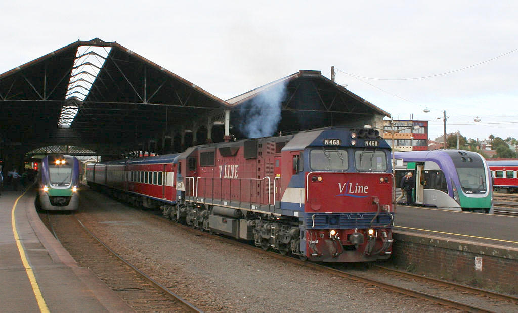
 V/Line passenger trains at Geelong Railway Station
Geelong is a major hub for Rail transport in Victoria being at the junction of the Geelong line, Warrnambool V/Line rail service, Western standard gauge line and the Geelong-Ballarat railway line.[26] There are seven passenger railway stations in the urban area, all along the Geelong line and all operated by V/Line[108] None of these lines are electrified and trains servicing Geelong are currently Diesel engine powered. The Geelong line offers hourly VLocity fast passenger services to Melbourne which are popular with commuters. According to V/Line the Geelong line carries more passengers than any other regional rail line in Australia.[109] Passenger services run to Warrnambool three times connecting Geelong with Colac, Terang and Camperdown. Great Southern Railway's The Overland service between Melbourne and Adelaide also stops at North Shore three times per week.[110] Freight trains also operate from Melbourne to Geelong serving local industries,[62] as well as to Warrnambool and other western Victorian towns. The main Melbourne-Adelaide standard gauge line sees heavy use carrying interstate freight.
Port and airport
The Port of Geelong is located on the shores of Corio Bay, and is the sixth largest seaport in Australia by tonnage.[111] Major commodities include crude oil and petroleum products, export grain and woodchips, alumina imports, and fertiliser.[112] The Bellarine Peninsula has been linked to the Mornington Peninsula since 1987[113] by the Searoad ferry, which runs every hour using two roll-on/roll-off ferries.[114]

Avalon Airport is located approximately 15 km (9.3 mi) to the north-east of the city of Geelong. It was established in 1953 to cater for the production of military aircraft.[115] It was also used for the repair of commercial aircraft, and for pilot training. Avalon Airport has also been home to low cost airline Jetstar Airways since 2004.[48] Flights to Brisbane and Sydney use the airport. Avalon Airport is the venue for 'Thunder Down Under' Australian International Airshow every other year.
Bus and taxi
 McHarry's Geelong Transport System bus at the Railway Terrace main bus terminal
A bus network covering the city centre and most surrounding suburbs providing public transport. They are operated under the umbrella of the Geelong Transit System, and are contracted to Benders Busways and McHarry's Buslines.[116] Another government transport initiative, Bellarine Transit, is contracted to McHarry's Buslines and provides interurban services between Geelong and the towns of Torquay, Barwon Heads, Ocean Grove and the Bellarine Peninsula.[108] V/Line services link Geelong with Ballarat, Daylesford, Bendigo, Apollo Bay, the Great Ocean Road, the Twelve Apostles and Warrnambool.[108]
 Off-Duty Geelong Taxi Network vehicle in Norlane
Taxi services in Geelong are provided by Geelong Taxi Network, a newly formed depot following the effective merger of Bay City Cabs and Geelong Radio Cabs in July 2007.[citation needed] The majority of the network covers the city and suburban areas of the city, with "urban" classification for the vehicles in use. The Bellarine Peninsula, and Torquay areas, although part of Geelong Taxi Network, are both covered by separate "country" classification taxis. There are often disputes in regards to different taxis from one licence area, picking up work from either of the other two licence areas, which is illegal in most circumstances under current taxi regulations in Victoria.[117] Call centre and radio dispatch services for the new combined network are provided by Silver Top Taxis in Melbourne.
Geelong also has many kilometres of bicycle trails covering the shores of Corio Bay and the Barwon River parklands, in addition to the Bellarine Rail Trail.[118]
Sports
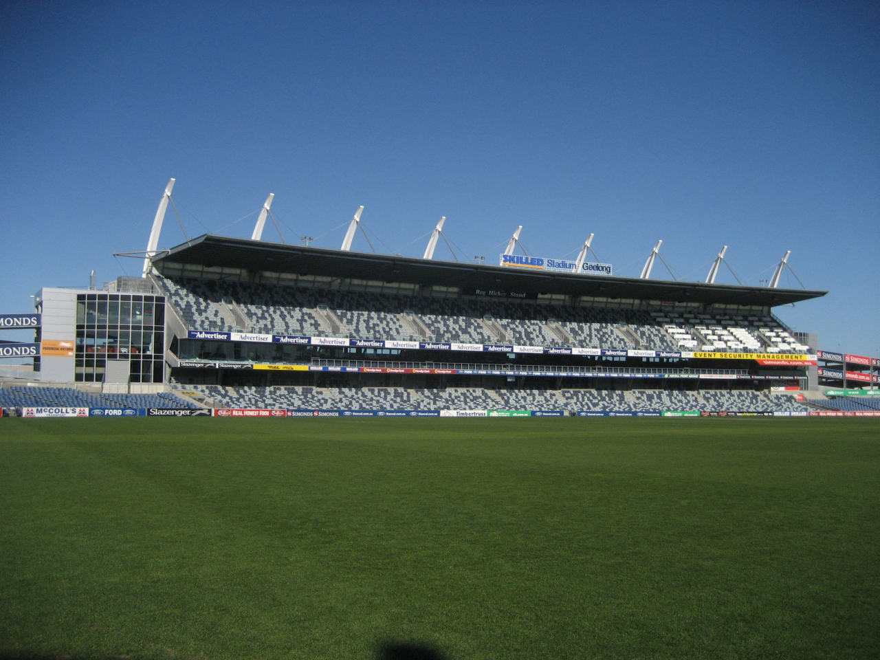
 Skilled Stadium (Kardinia Park), home of the Cats
Geelong is home to the Geelong Football Club Australian Football League team, the second oldest AFL club[119] and one of the oldest in the world. For many years it was the only VFL/AFL club to exist outside of the greater Melbourne metropolitan area. It continues to participate in the national competition, based at Kardinia Park stadium and Etihad Stadium in Melbourne, and also fields a reserves side in the Victorian Football League.[119] The club won the 2007 grand final against Port Adelaide by 119 points, the biggest grand final winning margin in history and the first Geelong premiership victory for 44 years.[120] The club also won the 2009 and 2011 AFL grand finals held at the Melbourne Cricket Ground. There are also three independent football leagues running in the area, the Geelong Football League, the Geelong & District Football League, and the Bellarine Football League.[121]
Geelong has a horse racing club, the Geelong Racing Club, which schedules around 22 race meetings a year including the Geelong Cup meeting in October.[122] The Geelong Cup was first run in 1872,[123] and is considered one of the most reliable guides to the result of the Melbourne Cup.[124] It also has a picnic horse racing club, Geelong St Patricks Racing Club, which holds its one race meeting a year in February.[125]
Geelong Harness Racing Club conducts regular meetings at its racetrack at Corio,[126] and the Geelong Greyhound Racing Club holds regular meetings.[127]
The Geelong Baseball Centre in Waurn Ponds is home of the Geelong Baycats. The Baycats are the only provincial team in Baseball Victoria's Division One competition and were the 2005/2006 State Champions. The Geelong Baseball Centre has hosted a number of National Championship, the 2002 Women's World Championships and was home to the Chiba Lotte Marines for spring training in 2005 and 2006.
The Arena stadium in North Geelong is the home of the Geelong Supercats basketball team, and was also used during the 2006 Commonwealth Games for basketball matches.[128]
 2007 Bay Classic Series at Eastern Beach.
The Eastern Beach foreshore and nearby Eastern Gardens regularly host internationally televised triathlons, and annual sports car and racing car events such as the Geelong Speed Trials.[129]
Corio Bay is also host to many sailing and yachting events. Geelong also has many golf courses, sporting and recreation ovals and playing fields, as well as facilities for water skiing, rowing, fishing, hiking, and greyhound and harness racing.[130] Geelong Athletics holds athletic competitions during both the summer and winter months including high profile events such as Victorian and sometimes national and international track and field meets.
See also
- Geelong Field Naturalists Club
- List of Heritage listed buildings in Geelong
- List of Mayors of Geelong
- Category:People from Geelong
- Electoral district of Geelong
References
- ^ a b c d e Australian Bureau of Statistics (25 October 2007). "Geelong (VIC) (Statistical District)". 2006 Census QuickStats. http://www.censusdata.abs.gov.au/ABSNavigation/prenav/LocationSearch?collection=Census&period=2006&areacode=2024&producttype=QuickStats&breadcrumb=PL&action=401. Retrieved 2007-09-27.
- ^ Macquarie Dictionary, Fourth Edition (2005). Melbourne, The Macquarie Library Pty Ltd. ISBN 1-876429-14-3
- ^ Moore, Bruce (ed.) (1999). The Australian Oxford Dictionary. Oxford University Press
- ^ "Early days of Geelong". The Argus: p. 9. 19 July 1924. http://trove.nla.gov.au/ndp/del/article/4266153. Retrieved 27 April 2011.
- ^ "Geelong City". City of Greater Geelong website. Archived from the original on 2007-10-28. http://web.archive.org/web/20071028100151/http://www.geelongaustralia.com.au/Visiting_Geelong/Towns/Geelong_City/. Retrieved 2007-12-16.
- ^ Premier Postal History. "Post Office List". https://www.premierpostal.com/cgi-bin/wsProd.sh/Viewpocdwrapper.p?SortBy=VIC&country=. Retrieved 2008-04-11
- ^ a b "Key drivers of change". City of Greater Geelong population forecast. http://www.id.com.au/geelong/forecastid/default.asp?id=268&gid=10&pg=2. Retrieved 2007-12-29.
- ^ a b c d e f g h i j k l m Norman Houghton - ""The Story of Geelong"". link. Archived from the original on 2007-10-28. http://web.archive.org/web/20071028094637/http://www.geelongaustralia.com.au/Visiting_Geelong/History/Story_of_Geelong/. Retrieved 2007-12-16.
- ^ "Historical perspective". Geelong Business News (via Wayback Machine). Archived from the original on 2005-06-15. http://web.archive.org/web/20050615223434/http://geelongbusiness.com.au/view_article.php?id=224. Retrieved 2007-12-29.
- ^ a b c d e f g h i j k l m Begg, Peter (1990). Geelong - The First 150 Years. Globe Press. ISBN 0-9592863-5-7.
- ^ a b c d e "Top 10 Reasons to Move to Geelong". City of Greater Geelong website. Archived from the original on 2007-10-28. http://web.archive.org/web/20071028095432/http://www.geelongaustralia.com.au/Visiting_Geelong/Geelong_Living/Top_10_Reasons_to_Move_to_Geelong/. Retrieved 2007-12-16.
- ^ "Regions get new lease on lifestyle". The Age (Melbourne). 14 April 2004. http://www.theage.com.au/articles/2004/04/13/1081838721413.html. Retrieved 2007-07-19.
- ^ "Wathaurong People". City of Greater Geelong website. Archived from the original on 2007-09-01. http://web.archive.org/web/20070901235538/http://www.geelongaustralia.com.au/Visiting_Geelong/Wathaurong_People/. Retrieved 2007-12-16.
- ^ a b c d e f Billot, C.P. (1969). The Life of Our Years. Lothian Publishing. National Library of Australia registry number 68-2473.
- ^ "Excerpts from the 'Port Phillip Survey 1957-1963'". Port Phillip Conservation Council website. http://home.vicnet.net.au/~phillip/env2stud.htm. Retrieved 2007-12-16.
- ^ "Grimes, Charles (1772 - 1858)". Australian Dictionary of Biography, Online Edition. http://www.adb.online.anu.edu.au/biogs/A010443b.htm. Retrieved 2007-12-30.
- ^ "Collins, David (1756 - 1810)". Australian Dictionary of Biography, Online Edition. http://www.adb.online.anu.edu.au/biogs/A010226b.htm. Retrieved 2007-12-30.
- ^ a b "Hovell, William Hilton (1786 - 1875)". Australian Dictionary of Biography, Online Edition. http://www.adb.online.anu.edu.au/biogs/A010517b.htm. Retrieved 2007-12-16.
- ^ "Reminiscences of James Buckley, communicated by him to George Langhorne, 1837". State Library of Victoria: Manuscript. http://www.slv.vic.gov.au/portphillip/inter/7335.shtml. Retrieved 2007-12-16.
- ^ a b c d "Timeline history". Geelong and District Historical Resources website. http://www.zades.com.au/geelong/gdtime.htm. Retrieved 2007-07-19.
- ^ "Buckley, William (1780 - 1856)". Australian Dictionary of Biography, Online Edition. http://www.adb.online.anu.edu.au/biogs/A010158b.htm. Retrieved 2007-12-16.
- ^ a b "Fyans, Foster (1790 - 1870)". Australian Dictionary of Biography, Online Edition. http://www.adb.online.anu.edu.au/biogs/A010389b.htm. Retrieved 2007-12-16.
- ^ "Letter from R.C. Gunn". Discovery of keys in the shore formation of Corio Bay, Royal Society of Victoria, [1875]. http://www.lib.monash.edu.au/exhibitions/history/xaustcat.html. Retrieved 2007-12-16.
- ^ "Australian Dictionary of Biography, Online Edition: Thomson, Alexander (1800 - 1866)". http://www.adb.online.anu.edu.au/biogs/A020478b.htm. Retrieved 2007-12-16.
- ^ http://www.ideafinder.com/history/inventions/refrigerator.htm
- ^ a b c d e f "Geelong Line Guide". Rail Geelong. http://railgeelong.com/lineguide.php?line=geelong. Retrieved 2007-12-16.
- ^ "Wild Rabbits Introduced". National Museum of Australia website. http://www.nma.gov.au/advancedSearchResultsItemDetail.jsp?irn=522. Retrieved 2007-12-16.
- ^ "FORMER HM TRAINING PRISON - 202 MYERS STREET AND CORNER SWANSTON STREET GEELONG, Greater Geelong City". Heritage Victoria: Heritage Register Online. http://www.heritage.vic.gov.au/page_239.asp?ID=239&submit_action=detailed_result&search_type=DLVHR&query=registerAll/CF3281DFD95D6768CA2573B6007C39E6?OpenDocument. Retrieved 2007-12-30.
- ^ "Berry, Sir Graham (1822 - 1904)". Australian Dictionary of Biography, Online Edition. http://www.adb.online.anu.edu.au/biogs/A030143b.htm. Retrieved 2007-12-16.
- ^ "Victorian Premiers Since Responsible Government, 1855 - Current". Parliament of Victoria website. Archived from the original on 2007-10-23. http://web.archive.org/web/20071023173017/http://www.parliament.vic.gov.au/minis.html. Retrieved 2008-01-15.
- ^ "Photograph". Market Square clock tower history plaque inside the Market Square Shopping Centre. http://en.wikipedia.org/wiki/File:Market_Square_clock_tower_history_plaque.jpg. Retrieved 2007-12-16.
- ^ a b "Fyansford Line Guide". Rail Geelong. http://railgeelong.com/lineguide.php?line=fyansford. Retrieved 2007-12-16.
- ^ "Geelong - a brief history". Intown Geelong website. http://www.intown.com.au/locals/geelong/historical/default.htm. Retrieved 2011-01-28.
- ^ "Agency VA 1425: Port of Geelong Authority". Public Record Office Victoria website. http://www.access.prov.vic.gov.au/public/component/daPublicBaseContainer?component=daViewAgency&entityId=1425. Retrieved 2007-12-16.
- ^ "Geelong tramways - a short history". Tramway Museum Society of Victoria (via Wayback Machine). Archived from the original on 2006-08-19. http://web.archive.org/web/20060819124009/http://tmsv.org.au/papers/geelong.htm. Retrieved 2007-06-13.
- ^ Geelong Ousts Ballarat. Population Surprises. The Argus (Melbourne) Tuesday 28 April 1936, page 10
- ^ a b R. Arklay and I. Sayer (September 1970). Geelong's Electric Supply.
- ^ "GPAC - About". http://www.gpac.org.au/about/default.aspx. Retrieved 2007-08-13.
- ^ "Geelong - Australian Animal Health Laboratory". CSIRO website. http://www.csiro.au/places/aahl.html. Retrieved 2007-12-16.
- ^ "National Wool Museum". City of Greater Geelong website. Archived from the original on 2007-08-31. http://web.archive.org/web/20070831135553/http://www.geelongaustralia.com.au/Visiting_Geelong/Attractions/National_Wool_Museum/About_the_Wool_Museum/. Retrieved 2007-12-16.
- ^ "Plaque marking opening of Bay City Plaza". Image. http://en.wikipedia.org/wiki/File:Bay_City_Plaza_Plaque_Geelong.jpg.
- ^ "Pyramid Building Society Ltd". Guide to Australian Business Records. http://www.gabr.net.au/archives/ABE2069a.htm. Retrieved 2007-12-22.
- ^ "Mysteries of the Pyramid. (Pyramid building society financial collapse)". The Economist (US), July 1990. http://findarticles.com/p/articles/mi_hb5037/is_199007/ai_n18314959. Retrieved 2007-12-22.[dead link]
- ^ "Geelong leads regional price boom". The Age website (Melbourne). 26 July 2003. http://www.theage.com.au/articles/2003/07/25/1059084208923.html. Retrieved 2007-12-30.
- ^ a b "Sale of Harding Park, Geelong". Victorian Auditor-General's Office. http://www.audit.vic.gov.au/reports_mp_psa/psa0105_hard.html. Retrieved 2007-07-01.
- ^ "The Waterfront Story" (PDF). City of Greater Geelong website. Archived from the original on 2007-11-08. http://web.archive.org/web/20071108123410/http://www.geelongaustralia.com.au/library/pdf/5053/62.pdf. Retrieved 2007-12-16.
- ^ "Geelong and Southern Vic: Floods (incl Landslides)". Emergency Management Australia website (via Google cache). http://72.14.253.104/search?q=cache:7Rj0b1B4ho8J:www.offi.gov.au/ema/emadisasters.nsf/c85916e930b93d50ca256d050020cb1f/75ff60bb70b6749fca256d3300057d56%3FOpenDocument+%22The+worst+floods+on+the+Barwon+River+since+1952+resulted%22&hl=en&ct=clnk&cd=1&gl=au&client=firefox-a. Retrieved 2007-12-30.
- ^ a b "History made as Avalon Airport welcomes first Jetstar flight" (PDF). Jetstar website. 1 June 2004. http://www.jetstar.com/pdf/news/20040601.pdf. Retrieved 2007-12-18.
- ^ a b "Strategic plan to manage urban growth south of Geelong". City of Greater Geelong website. 12 April 2005. Archived from the original on 2007-09-09. http://web.archive.org/web/20070909101112/http://www.geelongaustralia.com.au/Media_Releases/April_2005/Strategic_plan_to_manage_urban_growth_south_of_Geelong/. Retrieved 2007-12-25.
- ^ a b "Building bonanza drives city forward". Geelong News: pp. 8–9. 2007-07-18
- ^ "Premier announces new TAC site in Geelong". Transport Accident Commission website. http://www.tac.vic.gov.au/jsp/content/NavigationController.do?areaID=23&tierID=1&navID=63CC12CD7F00000101A5D19311EC6AC2&navLink=null&pageID=1323. Retrieved 2007-07-21.
- ^ "Move or move on, TAC workers told". The Age (Melbourne). 16 December 2005. http://www.theage.com.au/news/national/move-or-move-on-tac-workers-told/2005/12/16/1134703611302.html. Retrieved 2007-07-21.
- ^ Begg, Peter Twin towers earmarked for Mercer St Geelong Advertiser. 10 July 2008
- ^ Geelong Western Edge
- ^ "Ford's Geelong plant to close, 600 jobs lost". ABC News. 18 July 2007. http://www.abc.net.au/news/stories/2007/07/18/1981686.htm. Retrieved 2007-07-19.
- ^ a b Loney, Jack (1988). The Historic Barwon. Portarlington, Vic.: J. Lonely. ISBN 0 909191 37 9.
- ^ a b c "Geelong State of the Environment Report - Geological conditions". City of Greater Geelong website. http://www.geelongaustralia.com.au/soe/detail.asp?id=66. Retrieved 2007-12-29.
- ^ "Geelong Wine Fact Sheet". City of Greater Geelong website. Archived from the original on 2007-11-06. http://web.archive.org/web/20071106212051/http://www.geelongaustralia.com.au/Visiting_Geelong/Food_and_Wine/Geelong_Wine_Fact_Sheet/. Retrieved 2007-12-29.
- ^ "Alcoa - Victorian operations". Alcoa website. http://www.alcoa.com/australia/en/info_page/victoria_tours.asp. Retrieved 2007-12-25.[dead link]
- ^ "Waurn Ponds". Rail Geelong. http://railgeelong.com/locations.php?name=Waurn%20Ponds. Retrieved 2007-12-29.
- ^ a b c "Greater Geelong Planning Scheme (Section 21.22 INDUSTRY)" (DOC). Victoria Department of Planning and Community Development website. 2006-01-19. Archived from the original on 2008-04-09. http://web.archive.org/web/20080409224729/http://www.psdocs.dpcd.vic.gov.au/public/Greater+Geelong/21_mss22_ggee.doc. Retrieved 2007-12-25. (via Google)
- ^ a b "North Geelong Yard". Rail Geelong. http://www.railgeelong.com/locations.php?name=North%20Geelong%20Yard. Retrieved 2007-08-13.
- ^ "City by the Bay concept 1981". Intown Geelong website. http://www.intown.com.au/historic/city-by-the-bay.htm. Retrieved 2007-12-25.
- ^ "GEELONG ECONOMIC INDICATORS BULLETIN - 2001/2002" (PDF). City of Greater Geelong website. Archived from the original on 2007-09-01. http://web.archive.org/web/20070901213511/http://www.geelongaustralia.com.au/library/pdf/5175/80.pdf. Retrieved 2007-12-25.
- ^ "Weather/Climate/Light". Film Geelong website. Archived from the original on 2007-11-01. http://web.archive.org/web/20071101043157/http://www.filmgeelong.com.au/Geelong_at_a_Glance/Weather-Climate-Light/. Retrieved 2007-12-24.
- ^ "Climate". Department of Primary Industries website. http://www.dpi.vic.gov.au/dpi/vro/coranregn.nsf/pages/corangamite_climate. Retrieved 2007-12-22.
- ^ Australian Climate Averages - Climate classifications
- ^ a b "Climate statistics for 'GEELONG SEC' 1870 - 1970". Bureau of Meteorology website. http://www.bom.gov.au/climate/averages/tables/cw_087025_All.shtml. Retrieved 2007-12-24.
- ^ "Climate Averages for AVALON AIRPORT". Bureau of Meteorology website. http://www.bom.gov.au/climate/averages/tables/cw_087113_All.shtml. Retrieved 2007-12-25.
- ^ "Climate statistics for Geelong". Bureau of Meteorology. http://www.bom.gov.au/climate/averages/tables/cw_087163.shtml.
- ^ a b "Geelong Fast Facts" (PDF). City of Greater Geelong website. Archived from the original on 2007-08-29. http://web.archive.org/web/20070829045722/http://www.biogeelong.com.au/library/pdf/5240/67.pdf. Retrieved 2007-12-30.
- ^ "Geelong Otway Region Domestic Visitation 2001" (PDF). Geelong Otway Tourism website. Archived from the original on 2007-09-28. http://web.archive.org/web/20070928025012/http://www.geelongotway.org/admin/downloads/information/51506395215092004102141AM-stat.pdf. Retrieved 2007-12-16.
- ^ "Geelong". Monash University place names gazette (link broken). Archived from the original on 2007-08-31. http://web.archive.org/web/20070831224802/http://www.arts.monash.edu.au/ncas/multimedia/gazetteer/list/geelong.html. Retrieved 2007-12-16.
- ^ Sophie Smith (2 July 2008). "While Moorabool St remains cold and empty". Geelong News: p. 3.
- ^ a b "Solid economic growth driving Geelong prosperity". City of Greater Geelong website. 4 December 2007. Archived from the original on 2007-12-16. http://web.archive.org/web/20071216204006/http://www.geelongaustralia.com.au/Media_Releases/Solid_economic_growth_driving_Geelong_prosperity/. Retrieved 2007-12-29.
- ^ "Geelong's population surges". Geelong Advertiser website. 7 December 2007. http://www.geelongadvertiser.com.au/article/2007/12/07/9510_news.html. Retrieved 2007-12-29.
- ^ "GEELONG REGION CONTINUES TO GROW". Press release from the state Minister of Planning. 10 February 2005. http://www.legislation.vic.gov.au/domino/Web_Notes/newmedia.nsf/bc348d5912436a9cca256cfc0082d800/d3a895de9a7a63b1ca256fa500247ee5!OpenDocument. Retrieved 2007-12-29.
- ^ Šutalo, Ilija (2004). Croatians in Australia: Pioneers, Settlers and Their Descendants. Wakefield Press. ISBN 1 862546 51 7.
- ^ Tonci Prusac (28 October 2007). "Geelong Croatian voters to have significant say in Corio electorate". The New Generation (Croatian Herald English supplement). http://newgeneration.croatianherald.com/Feature/tabid/98/articleType/ArticleView/articleId/2151/Federal-Elections-2007.aspx. Retrieved 2007-12-29.
- ^ Pescott, John (1985). South Barwon 1857 - 1985. Neptune Press. ISBN 0 949583 53 7.
- ^ a b "Who can be a Councillor". City of Greater Geelong website. Archived from the original on 2007-09-02. http://web.archive.org/web/20070902121122/http://www.geelongaustralia.com.au/Accessing_Council/Elections/Who_can_be_a_Councillor/. Retrieved 2007-07-01.
- ^ "State Election 2006 Results: Electorate swings". Victorian Electoral Commission website. Archived from the original on 2007-11-30. http://web.archive.org/web/20071130000929/http://www.vec.vic.gov.au/electorateswing.html. Retrieved 2007-12-16.
- ^ "Divisional Profiles: Corio". Australian Electoral Commission website. http://www.aec.gov.au/profiles/c/Corio.htm. Retrieved 2007-12-16.
- ^ "Divisional Profiles: Corangamite". Australian Electoral Commission website. http://www.aec.gov.au/profiles/c/Corangamite.htm. Retrieved 2007-12-16.
- ^ "Seats won in the 2007 Federal Election". Australian Electoral Commission website. http://results.aec.gov.au/13745/website/HouseSeatsWon-13745-NAT.htm. Retrieved 2007-12-16.[dead link]
- ^ "About Barry". Barry Crocker official website. http://www.barrycrocker.net/about.htm. Retrieved 2007-12-30.
- ^ "Gyan Evans bio". Gyan Evans official website. http://www.gyan.com.au/bio.htm. Retrieved 2007-12-30.
- ^ "Magic Dirt overview". Allmusic. http://www.allmusic.com/artist/p194880. Retrieved 2007-12-30.
- ^ "Press: Middle-ground Man". Jeff Lang official website. Archived from the original on 2007-08-29. http://web.archive.org/web/20070829102318/http://www.jefflang.com.au/pressage.htm. Retrieved 2007-12-30.
- ^ "Denis Walter profile". 3AW website. http://www.mytalk.com.au/Stations_OLD/Talk/3AW/Pages/ProfileDenisWalter.aspx. Retrieved 2007-12-30.[dead link]
- ^ "The Venues". Geelong Performing Arts Centre website. http://www.gpac.org.au/venue/default.aspx. Retrieved 2007-12-30.
- ^ "Arts Venues". City of Greater Geelong website. Archived from the original on 2007-09-02. http://web.archive.org/web/20070902154410/http://www.geelongaustralia.com.au/Visiting_Geelong/Arts_and_Culture/Arts_Venues/. Retrieved 2007-12-30.
- ^ "About The Geelong Advertiser". Geelong Advertiser website. http://www.geelongadvertiser.com.au/about.html. Retrieved 2007-12-24.
- ^ "Oldest newspapers still in circulation". World Association of Newspapers website. http://www.wan-press.org/article2823.html. Retrieved 2007-12-24.
- ^ "Barwon Heads bridge wins its own sea change". The Age website (Melbourne). 16 March 2007. http://www.theage.com.au/news/national/bridge-wins-own-sea-change/2007/03/15/1173722655212.html. Retrieved 2007-12-24.
- ^ "The Town of Barwon Heads". http://www.barwonheads.net/TOWN/ABOUT.HTM. Retrieved 2007-12-16.
- ^ "Little River Earth Sanctuary". The Great Outdoors - Yahoo!7 Travel website. 23 June 2003. http://au.travel.yahoo.com/great-outdoors/australia/victoria/melbourne/little-river-earth-sanctuary-victoria.html. Retrieved 2007-12-24.
- ^ "Filming locations for December Boys (2007)". Internet Movie Database. http://www.imdb.com/title/tt0465436/locations. Retrieved 2007-12-24.
- ^ "Geelong filming of Nicholas Cage movie delayed". Geelong Advertiser. www.geelongadvertiser.com.au. 29 April 2008. http://www.geelongadvertiser.com.au/article/2008/04/29/13444_news.html. Retrieved 2008-07-06.
- ^ "History 1941 - Today". Gordon Institute of TAFE website. http://www.gordontafe.edu.au/index.cfm?action=2&secAction=7&terAction=2&pageAction=2. Retrieved 2007-12-19.
- ^ "Waurn Ponds campus". Deakin University website. http://www.deakin.edu.au/campuses/waurnponds.php. Retrieved 2007-12-19.
- ^ "Deakin medical school begins search for students". Geelong Advertiser website. 18 September 2007. http://www.geelongadvertiser.com.au/article/2007/09/18/6933_news.html. Retrieved 2007-12-30.
- ^ "Barwon Water - About Us". Barwon Water website. http://www.barwonwater.vic.gov.au/index.cfm?h2o=corporate.about_us. Retrieved 2007-12-16.
- ^ The Geelong Gas Company 1858 - 1958: 100 years of public service and progressive development
- ^ "GEELONG GAS COMPANY LIMITED". deListed website. http://www.delisted.com.au/Company/3376/GEELONG%20GAS%20COMPANY%20LIMITED. Retrieved 2007-08-17.
- ^ "About Geelong Ring Road". VicRoads website. http://www.vicroads.vic.gov.au/Home/RoadsAndProjects/RoadProjects/RegionalVictoria/GeelongRingRoad/default.htm. Retrieved 2007-12-18.
- ^ "Brumby Declares Geelong Ring Road Open". Geelong Advertiser. http://www.geelongadvertiser.com.au/article/2008/12/14/37395_news.html.
- ^ a b c "Greater Geelong". Viclink website. http://www.viclink.com.au/location/view/19. Retrieved 2007-12-18.
- ^ How busy is my Geelong train? V/Line
- ^ "The Overland Homepage". Great Southern Railway website. Archived from the original on 2007-12-10. http://web.archive.org/web/20071210234651/http://www.gsr.com.au/our-trains/the-overland/the-journey.php. Retrieved 2007-12-18.
- ^ "City of Greater Geelong - Sea". City of Greater Geelong website. Archived from the original on 2007-09-03. http://web.archive.org/web/20070903094716/http://www.geelongaustralia.com.au/Accessing_Council/Transportation/Sea/. Retrieved 2007-12-16.
- ^ "'Geelong port contributes $500mn a year to Victoria'". The Age (Melbourne). 12 September 2005. http://www.theage.com.au/news/business/geelong-port-contributes-500mn-a-year-to-victoria/2005/09/11/1126377204533.html. Retrieved 2007-12-16.
- ^ Peninsular Stamp Club (1987). Notes on the inauguration of the Peninsular Princess car / passenger ferry.
- ^ "DEPUTY PREMIER LAUNCHES $12 MILLION QUEENSCLIFF TO SORRENTO FERRY". Media Release from the Office of the Premier. 22 April 2001. http://www.dtf.vic.gov.au/domino/Web_Notes/MediaRelArc02.nsf/d025c300601da9dc4a25688e00143d49/e9fa53d63dc6e4ac4a256b510080ffb2!OpenDocument&Click=. Retrieved 2007-07-26.
- ^ "Avalon Hangar Conversion for Qantas? Skybed Fit-Out Adds to Meinhardt Aviation Portfolio". Meinhardt website. 10 December 2003. http://www.meinhardt.com.au/newsdeskdetail.php?nid=84. Retrieved 2007-12-18.
- ^ "Geelong Transit System". McHarry's Buslines website. Archived from the original on 2007-11-22. http://web.archive.org/web/20071122183219/http://www.mcharrys.com.au/McHGTS.html. Retrieved 2007-12-18.
- ^ "Move to Ban Bellarine Taxis in Geelong". Geelong Advertiser. http://www.geelongadvertiser.com.au/article/2008/09/25/18765_news.html.
- ^ "Bike Trails: Barwon River and Geelong Foreshore". City of Greater Geelong. Archived from the original on 2007-09-02. http://web.archive.org/web/20070902064240/http://www.geelongaustralia.com.au/Services_In_Geelong/Sports_and_Recreation/Bike_Trails/Barwon_River_and_Geelong_Foreshore/. Retrieved 2007-12-31.
- ^ a b "Geelong Football Club history". Geelong Football Club. http://www.gfc.com.au/TheClub/History/GFCHistory/tabid/4015/Default.aspx. Retrieved 2007-12-22.
- ^ "Drought over: Cats win by massive 119 points". Geelong Football Club website. http://www.gfc.com.au/Season2007/News/NewsArticle/tabid/3933/Default.aspx?newsId=51933. Retrieved 2007-12-22.
- ^ DARYL McLURE (24 May 2008). "Kick to kick". The Geelong Advertiser. www.geelongadvertiser.com.au. http://www.geelongadvertiser.com.au/article/2008/05/24/14299_opinion.html. Retrieved 2008-11-10.
- ^ Country Racing Victoria. "Alexandra Race Club". http://www.countryracing.com.au/index.php?option=com_club_info&club=59&Itemid=80. Retrieved 2009-05-07[dead link]
- ^ "Past Winners". Geelong Racing Club website. Archived from the original on 2007-10-09. http://web.archive.org/web/20071009151425/http://www.grc.com.au/cuppastwinners.htm. Retrieved 2007-12-22.
- ^ "Geelong Cup again a good guide". The Age website (Melbourne). 23 October 2007. http://www.theage.com.au/news/horse-racing/geelong-cup-again-a-good-guide/2007/10/22/1192940984902.html. Retrieved 2007-12-22.
- ^ Country Racing Victoria. "Geelong St Patricks Racing Club". http://www.countryracing.com.au/index.php?option=com_club_info&club=77&Itemid=80. Retrieved 2009-05-07[dead link]
- ^ Australian Harness Racing. "Geelong". http://www.harness.org.au/geelong/geelong.cfm?fromstate=vic. Retrieved 2009-05-11
- ^ Greyhound Racing Victoria. "Geelong". http://geelong.grv.org.au/index.html. Retrieved 2009-04-15[dead link]
- ^ "The Arena, Geelong". Office of Commonwealth Games Coordination website. Archived from the original on 2007-08-08. http://web.archive.org/web/20070808180500/http://www1.dvc.vic.gov.au/ocgc/traffic+and+transport/guide/the-arena-geelong.html. Retrieved 2007-12-22.
- ^ "Home Page". Geelong Speed Trials. http://www.geelongspeedtrials.com. Retrieved 2007-12-16.
- ^ "Reserves Listing". City of Greater Geelong website. Archived from the original on 2007-12-14. http://web.archive.org/web/20071214142509/http://www.geelongaustralia.com.au/Services_In_Geelong/Sports_and_Recreation/Reserves_Listing/. Retrieved 2007-12-22.
External links
- Official Geelong Government Site
- Official Website of the Geelong Otway Tourism Region of the Great Ocean Road
- Official G21 - Geelong Region Alliance Site including Growth Statistics
Cities of Victoria, Australia Regional VictoriaArarat · Bairnsdale · Ballarat · Benalla · Bendigo · Castlemaine · Colac · Echuca · Geelong · Hamilton · Horsham · Maryborough · Mildura · Moe · Morwell · Portland · Sale · Shepparton · Swan Hill · Traralgon · Wangaratta · Warrnambool · Wodonga Suburbs and localities of GeelongArmstrong Creek Growth Area • Bell Park • Bell Post Hill • Belmont • Breakwater • Corio • Drumcondra • East Geelong • Fyansford • Geelong City • Geelong West • Grovedale • Hamlyn Heights • Herne Hill • Highton • Lara • Leopold • Lovely Banks • Manifold Heights • Marshall • Moolap • Mount Duneed • Newcomb • Newtown • Norlane • North Geelong • North Shore • Rippleside • Rosewall • St Albans Park • South Geelong • Thomson • Wandana Heights • Waurn Ponds • WhittingtonAnakie • Avalon • Balliang • Barwon Heads • Batesford • Breamlea • Ceres • Clifton Springs • Connewarre • Curlewis • Drysdale • Indented Head • Little River • Mannerim • Marcus Hill • Moorabool • Ocean Grove • Point Wilson • Portarlington • Staughton Vale • St Leonards • Swan Bay • Wallington
Cities of Australia Australian Capital Territory Canberra (national capital)New South Wales Albury · Armidale · Bathurst · Broken Hill · Cessnock · Coffs Harbour · Dubbo · Gosford · Goulburn · Grafton · Griffith · Lake Macquarie · Lismore · Lithgow · Maitland · Newcastle · Nowra · Orange · Queanbeyan · Sydney · Tamworth · Wagga Wagga · WollongongNorthern Territory Queensland Brisbane · Bundaberg · Cairns · Caloundra · Gladstone · Gold Coast · Gympie · Hervey Bay · Mackay · Maryborough · Mount Isa · Rockhampton · Sunshine Coast · Toowoomba · TownsvilleSouth Australia Adelaide · Mount Gambier · Murray Bridge · Port Augusta · Port Lincoln · Port Pirie · Victor Harbor · WhyallaTasmania Victoria Ararat · Bairnsdale · Ballarat · Benalla · Bendigo · Castlemaine · Colac · Geelong · Hamilton · Horsham · Maryborough · Melbourne · Mildura · Moe · Morwell · Portland · Sale · Shepparton · Traralgon · Wangaratta · Warrnambool · WodongaWestern Australia Categories:- Geelong
- Cities in Victoria (Australia)
- Coastal cities in Australia
- Port cities in Australia
- Wine regions of Victoria (Australia)
- Australian Aboriginal placenames


Wikimedia Foundation. 2010.