- North Shore, Victoria
-
North Shore
Geelong, Victoria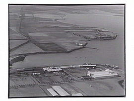
North Shore in 1927. Corio Quay is in the foreground.Population: 319 (2006)[1] Postcode: 3214 Area: 2.2 km² (0.8 sq mi) LGA: City of Greater Geelong State District: Lara Federal Division: Corio Suburbs around North Shore: Corio Norlane North Shore Corio Bay North Geelong North Shore is an industrial and residential suburb of Geelong, Victoria, Australia. The suburb overlooks Corio Bay. A small residential area is east of the North Shore railway station with a few neighbourhood shops.
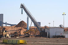 Midway Limited's Woodchipping Plant at North Shore
The suburb is bounded by the Geelong to Melbourne railway line to the west, St Georges Road to the north, Corio Bay to the east, and Cowies Creek to the south.
Contents
History
In 1892 the North Shore area was subdivided as a residential area and bayside retreat. An esplanade and linear park were laid out and planted with trees, the remaining fragment now being Moorpanyal Park. A small jetty was constructed and 10 years later North Shore was a small holiday resort.[2]
The Post Office opened on 27 August 1898. It was known as Corio from 1908 until 1913, before reverting to North Shore.[3]
Industrialisation commenced in 1899 when a meat freezing works was opened.[4]
During the 1920s there were several land subdivisions in the Geelong area. One of them was "Fordtown", and the name was well enough accepted to appear on a 1923 Army Survey map. To the west of the bayside industry residential areas were developed.
In 1925 the Ford Motor Works and the Pivot phosphate works opened,[5] and in 1929 the Corio distillery opened.[6]
The mouth of Cowies Creek was excavated to become Corio Quay from 1909,[7] with the creation of Lascelles Wharf to the north in later years. In the postwar years International Harvester opened its plant near Ford in 1946,[8] and at the northern end of North Shore the Shell Oil refinery was built from 1952. Later factories included Coca Cola Bottlers, Pilkington Glass and BHP Steel processing mills.
As well as having port facilities the industries had the Melbourne - Geelong railway line for freight carriage.
The suburb has an Australian Rules football team competing in the Geelong Football League.
Census populations
- 1921 - 124
- 1947 - 365
See also
- North Shore railway station
- North Shore Primary School
References
- ^ Australian Bureau of Statistics (25 October 2007). "North Shore (State Suburb)". 2006 Census QuickStats. http://www.censusdata.abs.gov.au/ABSNavigation/prenav/LocationSearch?collection=Census&period=2006&areacode=SSC22111&producttype=QuickStats&breadcrumb=PL&action=401. Retrieved 2007-10-01.
- ^ City of Greater Geelong - North Shore
- ^ Premier Postal History, Post Office List, https://www.premierpostal.com/cgi-bin/wsProd.sh/Viewpocdwrapper.p?SortBy=VIC&country=, retrieved 2008-04-11
- ^ Rail Geelong: North Shore Freezing Works
- ^ Rail Geelong: North Shore Phosphate Works
- ^ Rail Geelong: Corio Distillery
- ^ Rail Geelong: Corio Quay
- ^ Rail Geelong: international Harvester
Coordinates: 38°05′56″S 144°22′23″E / 38.099°S 144.373°E
 Suburbs and localities of GeelongArmstrong Creek Growth Area • Bell Park • Bell Post Hill • Belmont • Breakwater • Corio • Drumcondra • East Geelong • Fyansford • Geelong City • Geelong West • Grovedale • Hamlyn Heights • Herne Hill • Highton • Lara • Leopold • Lovely Banks • Manifold Heights • Marshall • Moolap • Mount Duneed • Newcomb • Newtown • Norlane • North Geelong • North Shore • Rippleside • Rosewall • St Albans Park • South Geelong • Thomson • Wandana Heights • Waurn Ponds • WhittingtonAnakie • Avalon • Balliang • Barwon Heads • Batesford • Breamlea • Ceres • Clifton Springs • Connewarre • Curlewis • Drysdale • Indented Head • Little River • Mannerim • Marcus Hill • Moorabool • Ocean Grove • Point Wilson • Portarlington • Staughton Vale • St Leonards • Swan Bay • WallingtonCategories:
- Suburbs of Geelong


Wikimedia Foundation. 2010.