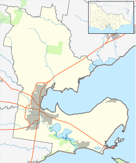
- Corio, Victoria
-
Corio
Geelong, VictoriaPopulation: 14,919 (2006)[1] Established: 1860s Postcode: 3214 Area: 12.6 km² (4.9 sq mi) Location: 9 km (6 mi) from Geelong LGA: City of Greater Geelong State District: Lara Federal Division: Corio Suburbs around Corio: Lara Lovely Banks Corio Bell Park Norlane North Shore Corio is a residential, industrial and one of the largest suburbs of Geelong, Victoria, Australia, located approximately 9 km north of the Geelong central business district. The area was formerly known as Cowie's Creek after James Cowie, an early land owner active in Local and State Government.[2]
Contents
History
Explorers Hume and Hovell reached the area of Corio and reported Aboriginals referring to the area as 'Corago', possibly leading to the current name of Corio. Land was first subdivided and sold in the area of Cowies Creek in 1852. By the 1860s, Cowie's Creek was home to two hotels and a population of approximately 500 people. The Post Office opened on November 16, 1864 (Corio from 1913). The current Post Office is situated within the Corio Shopping Centre on the ground floor having moved from its original first floor location.[3]
In 1914 the Geelong Grammar School moved to its current location near Corio Bay.
The Corio Village Shopping Centre was opened in 1973. The Shopping Centre currently includes a K-Mart, Coles, Woolworths, Best and Less, McDonalds, Subway, Gloria Jean's Coffees, Angus and Robertson book store, Optus and Telstra outlets, Cotton On, Millers, a Tattslotto agency, major banks and Australian Government agencies including Australia Post and a Centrelink office. After a re-developent in 2007/08, it is now known as the Corio Shopping Centre.
The Aldi supermarket chain built a store adjacent to Beckley Park in the mid 2000's, whilst Harvey Norman, Bunnings and Hungry Jacks are located on the Princes Highway entering Geelong from Melbourne. Near here is a new retail development currently being built (2008) with a Red Rooster store at its entrance.
Industry
Industry in Corio includes a Shell refinery built in 1956.
Transport
Cars are a popular method of transport within Corio. Benders Busways provides bus transport from most areas of Corio to the Geelong Central business district. Taxis are also available. Corio also has a railway station, served by V/Line trains to Geelong. Corio will be bypassed by traffic on the Princes Freeway by the creation of the Geelong Bypass that was completed in 2009.
Sport
The town has an Australian rules football football team, founded in 1974, competing in the Geelong & District Football League. Also linked with the Corio Sporting Club is the cricket club, little league, founded in 1977 and the netball club.[4]
The Corio Athletic Club, founded in 1969, competes at Landy Field in South Geelong and the Corio Little Athletics Centre, founded in 1967 competes at the Corio Athletics Stadium in Goldsworthy Road, which was opened in 1972 by Ron Clarke.
See also
References
- ^ Australian Bureau of Statistics (25 October 2007). "Corio (State Suburb)". 2006 Census QuickStats. http://www.censusdata.abs.gov.au/ABSNavigation/prenav/LocationSearch?collection=Census&period=2006&areacode=SSC22026&producttype=QuickStats&breadcrumb=PL&action=401. Retrieved 2007-10-01.
- ^ City of Greater Geelong - Ward Boundaries 2004
- ^ Premier Postal History, Post Office List, https://www.premierpostal.com/cgi-bin/wsProd.sh/Viewpocdwrapper.p?SortBy=VIC&country=, retrieved 2008-04-11
- ^ Full Points Footy, Corio, http://www.fullpointsfooty.net/corio.htm, retrieved 2008-07-25
External links
Coordinates: 38°04′26″S 144°21′32″E / 38.074°S 144.359°E
 Suburbs and localities of GeelongArmstrong Creek Growth Area • Bell Park • Bell Post Hill • Belmont • Breakwater • Corio • Drumcondra • East Geelong • Fyansford • Geelong City • Geelong West • Grovedale • Hamlyn Heights • Herne Hill • Highton • Lara • Leopold • Lovely Banks • Manifold Heights • Marshall • Moolap • Mount Duneed • Newcomb • Newtown • Norlane • North Geelong • North Shore • Rippleside • Rosewall • St Albans Park • South Geelong • Thomson • Wandana Heights • Waurn Ponds • WhittingtonAnakie • Avalon • Balliang • Barwon Heads • Batesford • Breamlea • Ceres • Clifton Springs • Connewarre • Curlewis • Drysdale • Indented Head • Little River • Mannerim • Marcus Hill • Moorabool • Ocean Grove • Point Wilson • Portarlington • Staughton Vale • St Leonards • Swan Bay • WallingtonCategories:
- Suburbs of Geelong
- Victoria (Australia) geography stubs
Wikimedia Foundation. 2010.

