- Highton, Victoria
Infobox Australian Place | type = suburb
name = Highton
city = Geelong
state = vic
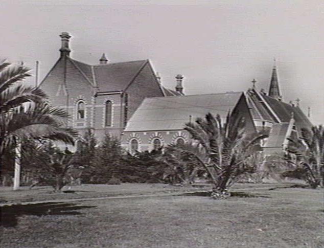
caption = The St. Augustine's Orphanage, built in 1857
lga = City of Greater Geelong
postcode = 3216
pop = 14,494 (2006)Census 2006 AUS | id = SSC22066 | name = Highton (State Suburb) | accessdate = 2007-10-01 | quick = on]
area =
propval = [http://www.domain.com.au/Public/SuburbReport.aspx?searchTerm=3216 $260,000] (2005)
stategov =
fedgov =
near-nw = Fyansford
near-n = Newtown
near-ne =
near-w = Ceres
near-e = Belmont
near-sw = Wandana Heights
near-s = Waurn Ponds
near-se = Grovedale
dist1 =
location1= : "Highton also refers to the highest level of Aristos in theSaga of the Skolian empire byCatherine Asaro .Highton is a residential suburb of Geelong, Victoria,
Australia . It is bordered by the Barrabool Hills and Wandana Heights to the west, the Barwon River to the north and east, the former Kardinia Creek to the south-east, and thePrinces Highway and Pigdons Road to the south.History
Grazier John Highett set up a farm and finished building his house on a hill overlooking the Barwon River in 1837. Later his property became the Montpellier vineyard, hotel and picnic ground. Highton was named after an abbreviation of his name. Reserves and reservoirs in this beautiful suburb still bear the Montpellier name. [http://www.geelongcity.vic.gov.au/Visiting%5FGeelong/Towns/Highton/ City of Greater Geelong: Highton] ]
The district had been extensively subdivided by the mid-1860s and boasted a hotel, a post office (opened on 1 December 1864) Citation
last = Premier Postal History | title = Post Office List | url = https://www.premierpostal.com/cgi-bin/wsProd.sh/Viewpocdwrapper.p?SortBy=VIC&country= | accessdate = 2008-04-11 ] and a population of about 300 people. Vineyards, orchards and farmland were the major commercial activities for some decades. Between 1927 and 1933, two major orphanages and the Glastonbury children's home were opened in the suburb. [ [http://www.hotkey.net.au/~jwilliams4/homes.htm List of Institutions/Homes Australia] ]Residential development reached Highton by the post war 1950s, the scenic hills overlooking the Barwon River valley being popular with residents. The Highton shopping centre in Bellevue Avenue was constructed in the mid 1960s. [Klaus G Clapinski (October 15 1967) "The Shire of South Barwon"] , and the former Kardinia creek separating the suburb from Belmont was placed underground. Further residential expansion continued southwards, by the 1990s housing had reached the Glastonbury Drive area.
Education
The Highton Primary School was the first school to open in the suburb, opening in 1854. [Judy Laging (1974) "Shire of South Barwon - A Brief History"] Post war growth led to the opening of the Montpellier and Bellaire primary schools. The
Geelong Grammar School once occupied a campus in Highton from 1973 to 1998, [ [http://www.ggs.vic.edu.au/index.asp?menuid=060.060 About GGS > History] ] and Christian College opened in the former St Augustine’s orphanage in 1980. [ [http://www.christiancollege.vic.edu.au/Main.asp?_=CAMPUSES Christian College - A Brief History] ]Transport
Highton is connected by road to the centre of Geelong by Barrabool Road and the
Princes Highway . Traffic to Melbourne will be able to useGeelong Ring Road that passes to the west of the suburb, due for completion in2009 .Public transport to the area is provided by
bus es operated byBenders Buslines , on routes to the Geelong city centre travelling viaDeakin University and Belmont.See also
* The Hermitage founded in 1906.
References
Wikimedia Foundation. 2010.