- Gladstone, Queensland
-
Gladstone
Queensland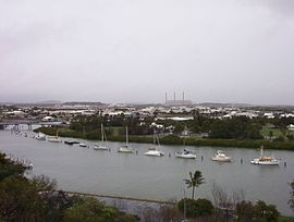
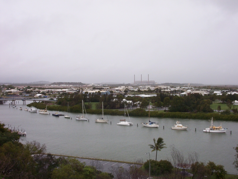
Auckland Inlet, with the Gladstone Power Station in the background
 Gladstone
Population: 28,808[1] Area: 147 km² (56.8 sq mi) Time zone: AEST (No Daylight Saving) (UTC+10) Location: 532 km (331 mi) from Brisbane LGA: Gladstone Regional Council, City of Gladstone State District: Gladstone Federal Division: Flynn Mean max temp Mean min temp Annual rainfall 27.7 °C
82 °F18.5 °C
65 °F880.0 mm
34.6 inGladstone is an Australian city located approximately 550 kilometres by road north of Brisbane and 100 kilometres south-east of Rockhampton. Situated between the Calliope and Boyne Rivers, Gladstone is home to Queensland's largest multi-commodity port.
The city's population at the 2006 Census was 28,808,[1] of whom 3.7 percent are of Aboriginal and Torres Strait Islander origin.[1]
The City of Gladstone contains a land area of 128 square kilometres. In addition to the mainland area, the Local Authority Area contains fourteen (14) islands. The Gladstone Regional Council, formed in 2008, amalgamates multiple previous local government areas.
Contents
History
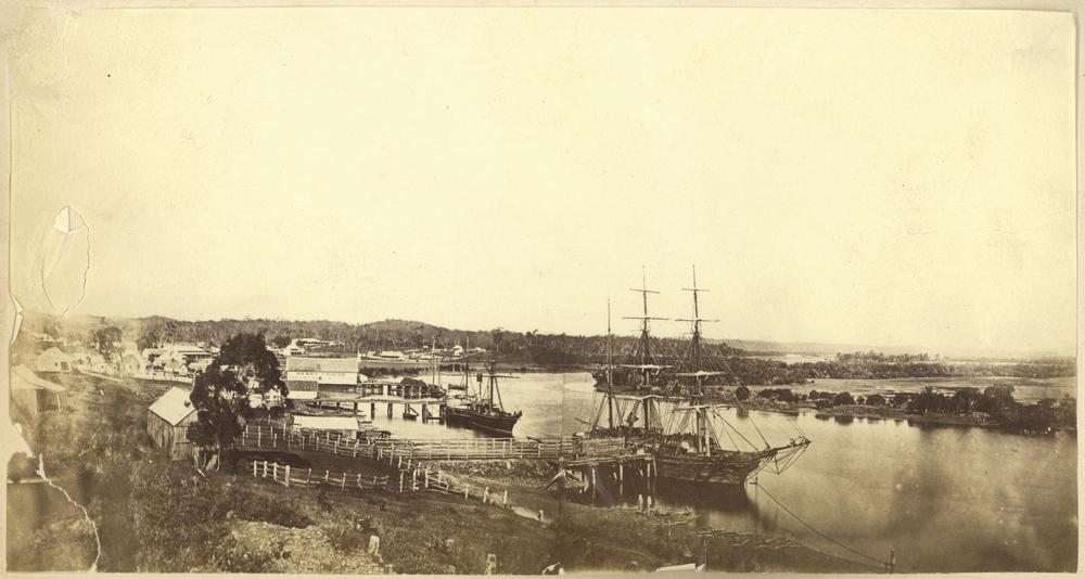
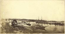 Ships moored at the docks at Gladstone, ca. 1868.
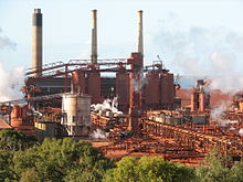 Qld Alumina Refinery
Prior to European settlement, the Gladstone region was home of the Baiali (or Byellee), Goereng and Goreng Goreng Aboriginal tribes.
In May 1770, the HM Bark Endeavour, under the command of James Cook, sailed by the entrance to Gladstone Harbour under the cover of darkness. Matthew Flinders, during his 1801–1803 circumnavigation of Australia, became the first recorded European to sight the harbour in August 1802. He named the harbour Port Curtis, after Admiral Roger Curtis, a man who was of assistance to Flinders years earlier at the Cape of Good Hope. John Oxley conducted further exploration of the harbour and surrounding countryside in November 1823. Oxley was dismissive of the region, noting the harbour was difficult to enter, the countryside was too dry, and the timber useless for construction purposes.
Nevertheless, a colony was eventually established at Port Curtis. Colonel George Barney's expedition was eventful. On 25 January 1847, the Lord Auckland, carrying 87 soldiers and convicts, arrived off the southern entrance of Port Curtis and promptly ran aground on shoals off the southern tip of Facing Island. The settlers spent seven weeks on the island before being rescued by the supply ship Thomas Lowry and delivered the intended site of settlement, the region now known as Barney Point.
On 30 January at a proclamation ceremony, Barney was officially sworn in as Lieutenant Governor of the colony of North Australia.[2] The convict settlement lasted barely two months. A change of government in Britain ordered the withdrawal of Barney and the settlers. However, interest in the region remained. By 1853, Francis MacCabe was surveying the site of a new town on the shores of Port Curtis. Maurice O'Connell was appointed government resident the following year, resulting in an influx of free settlers as land became available throughout the region. In 1863, the town became a Municipality with Richard Hetherington elected Gladstone's first mayor.
The fledgling town was named after the British statesman William Ewart Gladstone and has a 19th century marble statue on display in its town museum.[3]
Development of Gladstone was slow until 1893, when a meatworks was established at Parsons Point. In 1963, Queensland Alumina Limited established its alumina refinery on the site of the old meatworks. Gladstone's port facilities were expanded and the city launched into an era of industrial development and economic prosperity.
In the sister city program, Gladstone is twinned with the Japanese port of Saiki.[4]
Geography
Climate
Gladstone experiences a tropical savanna climate (Köppen climate classification Aw) and is one of the southernmost places in Australia to have this type of climate.
Climate data for Gladstone Month Jan Feb Mar Apr May Jun Jul Aug Sep Oct Nov Dec Year Average high °C (°F) 31.2
(88.2)30.9
(87.6)30.2
(86.4)28.4
(83.1)25.7
(78.3)23.2
(73.8)22.8
(73.0)24.0
(75.2)26.4
(79.5)28.4
(83.1)29.9
(85.8)31.0
(87.8)27.7 Average low °C (°F) 22.5
(72.5)22.4
(72.3)21.5
(70.7)19.6
(67.3)17.0
(62.6)14.3
(57.7)13.3
(55.9)14.2
(57.6)16.4
(61.5)18.7
(65.7)20.5
(68.9)21.9
(71.4)18.5 Precipitation mm (inches) 143.4
(5.646)143.4
(5.646)82.6
(3.252)46.2
(1.819)60.5
(2.382)39.4
(1.551)35.2
(1.386)32.4
(1.276)26.5
(1.043)62.3
(2.453)74.2
(2.921)128.8
(5.071)880.0
(34.646)Source: Australian Bureau of Meteorology[5] Education
Gladstone has several primary schools, three high schools, and one university campus, Central Queensland University. It is also home to CQIT (TAFE) Gladstone Campus.
Recreation
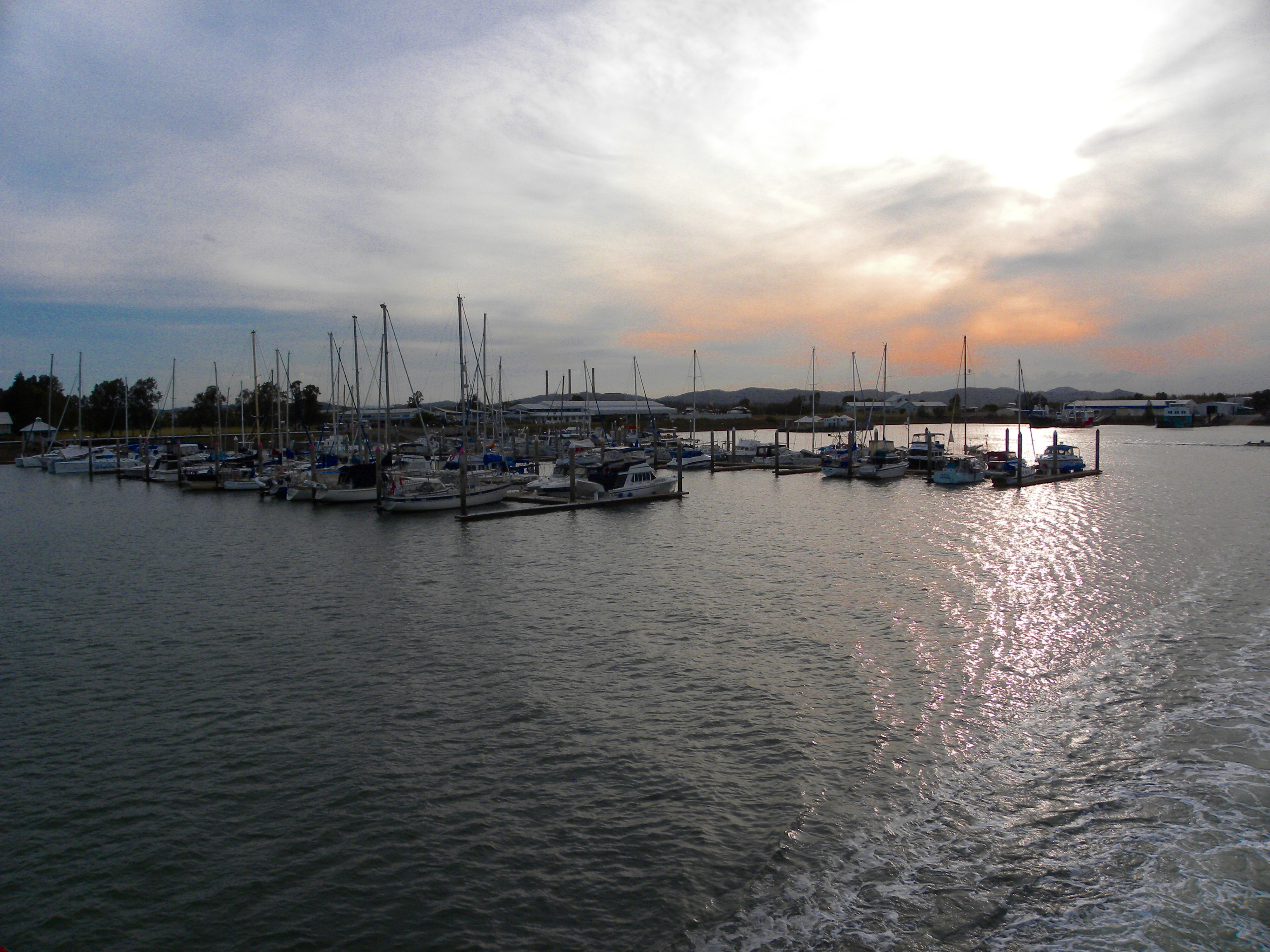
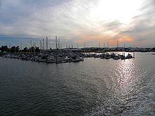 Sunset from the Gladstone Marina
Gladstone has direct access to Heron Island, Wilson Island and other islands from the marina and local airstrips.
Boyne Island and Tannum Sands
Main articles: Boyne Island, Queensland and Tannum Sands, QueenslandBoyne Island and Tannum Sands have grown in popularity because of their beautiful beaches and relaxed lifestyle. The Millennium Esplanade is a big attraction where there are lots of shelters, barbecues and walking paths, and long stretches of beach. Boyne Island and Tannum Sands are not part of the Gladstone township but are part of the Gladstone region and formerly part of the Calliope Shire.[6]
Lake Awoonga
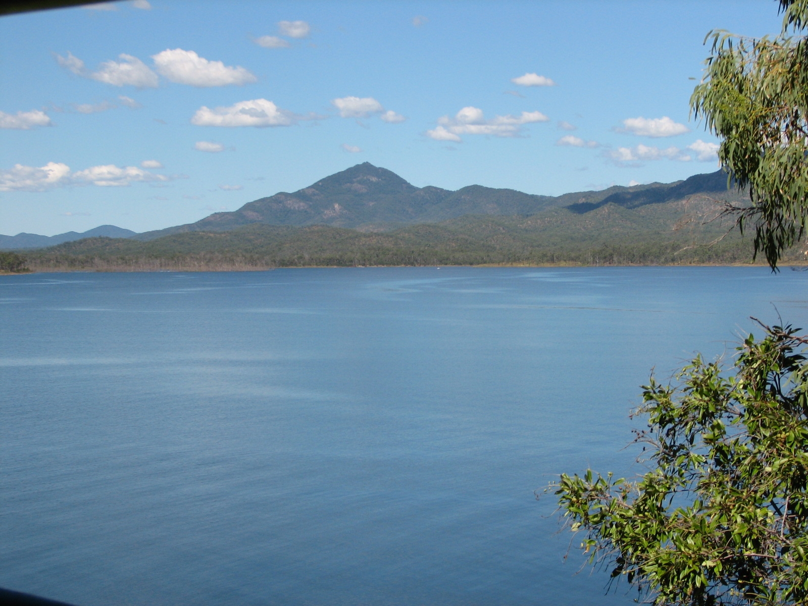
Main article: Lake Awoonga Lake Awoonga
A little further afield (25 km south of Gladstone) is Lake Awoonga. The recreation area has free barbecues, swimming, landscaped walking trails, as well as a caravan park. The lake has been stocked with several fish species since 1996, and over 2 million barramundi have been released. In addition to the fishing, Lake Awoonga has many natural attractions, especially the wildlife, with more than 225 species of birds (or over 27% of Australia's bird species) found in the region. Lake Awoonga is also the primary source of Gladstone's water supply. Awoonga dam is not part of the Gladstone township but is part of the Gladstone region and formerly part of the Calliope Shire.
Politics
Gladstone is located in the federal electoral division of Flynn, a marginal seat in Federal elections, and the state electoral division of Gladstone. 40% of voters in Flynn are located in Gladstone. Gladstone is represented by Liz Cunningham in State Parliament, who sits as an independent, and Flynn by Ken O'Dowd in Federal Parliament, who is a member of the Liberal National Party of Queensland.[7]
Transport
The Dawson Highway originates in Gladstone, and it runs for approximately 400 km to Springsure.
Rail
Gladstone is also a major stop on the North Coast railway line, with many long-distance passenger trains operated by QR Traveltrain stopping in the area. Freight trains also pass through the region.
Long Distance services Inbound Service Outbound Miriam Vale The Sunlander Mount Larcom Miriam Vale Electric Tilt Train Mount Larcom Bundaberg Diesel Tilt Train Rockhampton Miriam Vale Spirit of the Outback Mount Larcom Air
Gladstone Airport is located in the western suburbs of Gladstone about 6 km (8 minute drive) from the centre of the city.
The main provider of scheduled passenger air services has been Qantaslink, though Flight West Airlines also previously offered service. Strategic Airlines began to offer service in 2011 and Virgin Australia will commence flights in October 2011. Most flights are non-stop to Brisbane.
In May 2009, a $65 million upgrade to the airport and nearby area was undertaken,[8] which reached completion in 2011.
Sea
The Port of Gladstone is Queensland's largest multi-commodity port and the fifth largest multi-commodity port in Australia. It is the world's fourth largest coal exporting terminal.[9]
See also
- Kroombit Tops National Park
- Beautiful Betsy
- The Boyne Valley
- Monto
- Calliope, Queensland
- Tannum Sands, Queensland
- Ubobo, Queensland
- Nagoorin, Queensland
- Builyan, Queensland
- Many Peaks, Queensland
- Lake Awoonga
These above places are part of the Gladstone Region but were formerly part of the Calliope & Miriamvale Shires
References
- ^ a b c Australian Bureau of Statistics (25 October 2007). "Gladstone (Urban Centre/Locality)". 2006 Census QuickStats. http://www.censusdata.abs.gov.au/ABSNavigation/prenav/LocationSearch?collection=Census&period=2006&areacode=UCL322800&producttype=QuickStats&breadcrumb=PL&action=401. Retrieved 17 May 2010.
- ^ Early History of Port Curtis[dead link]
- ^ Gladstone City & Hinterland[dead link]
- ^ Saiki Sister City[dead link]
- ^ "Climate statistics for Gladstone AWS". Australian Bureau of Meteorology. June 2011. http://www.bom.gov.au/climate/averages/tables/cw_039123.shtml. Retrieved 11 May 2009.
- ^ Gladstone Regional Council Website 2011. Gladstone.qld.gov.au. Retrieved on 18 August 2011.
- ^ http://vtr.aec.gov.au/HouseDivisionFirstPrefs-15508-311.htm
- ^ Media Release: Opening marks milestone in region’s history. None. Retrieved on 18 August 2011.
- ^ "Mystery carrier causing a buzz". Gladstone Observer (APN News & Media). 3 December 2010. http://www.gladstoneobserver.com.au/story/2010/12/03/carrier-causing-a-buzz-gladstone-port-army-tanks/. Retrieved 5 December 2010.
External links
Coordinates: 23°50′56″S 151°15′47″E / 23.849°S 151.263°E
Cities of Queensland, Australia
Capital: BrisbaneRegional: Bundaberg · Cairns · Gladstone · Gympie · Hervey Bay · Mackay · Maryborough · Mount Isa · Rockhampton · Toowoomba · Townsville
Categories:- Cities in Queensland
- Port cities in Australia
- Coastal cities in Australia


Wikimedia Foundation. 2010.