- Rockhampton, Queensland
Infobox Australian Place
type = city
name = Rockhampton
state = qld
imagesize = 250
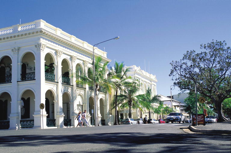
caption = Quay Street
pop = 74,530
pop_footnotes = (June 2007 Resident Population - Statistical District)Cite web|url=http://www.abs.gov.au/AUSSTATS/abs@.nsf/DetailsPage/3218.02006-07?OpenDocument|title=3218.0 - Regional Population Growth, Australia, 2006-07|publisher=Australian Bureau of Statistics |date=2008-03-31|accessdate=2008-07-19]
poprank = 24th
density =
density_footnotes =
est = 1858
postcode = 4700, 4701, 4702
coordinates = coord|23|22.5|S|150|30.7|E|type:city_region:AU-QLD|display=inline,title
elevation = 11.3
elevation_footnotes=
area =
area_footnotes =
timezone = AEST
utc = +10
dist1 = 636
dir1 = NW
location1 =Brisbane
lga =Rockhampton Regional Council
region =Capricorn Coast
county =
stategov = Rockhampton
stategov2 = Fitzroy
stategov3 = Keppel
fedgov = Capricornia
maxtemp = 28.3
mintemp = 16.6
rainfall = 795.0Rockhampton is a regional city and Local Government Area located in
Queensland ,Australia . Rockhampton is the largest urban centre inCentral Queensland with the 2006 census recording the Rockhampton Statistical Subdivision population to be 68,835 people. Rockhampton is seen as the unofficial capital Fact|date=May 2008 ofCentral Queensland as it hosts a significant number of governmental, community and major business administrative offices for the central part of the state.Rockhampton enjoys over 300 days of sunshine each year, [ [http://www.rockhamptoninfo.com.au/about/lifestyle/ Rockhampton Lifestyle] "Rockhampton Regional Council" - Accessed
4 June 2008 ] which lends itself to tourism activities all year round and an abundance of outdoor activities. Popular attractions include Riverbank Parklands, a riverfront parkland attraction located on the banks of Fitzroy River; theCapricorn Coast , the coastal strip betweenYeppoon andEmu Park andGreat Keppel Island , a large neighbouring island off theCapricorn Coast , the vast majority of which is national park.History
The Rockhampton district is the traditional home of the
Darumbal Aboriginal people. [McDonald, L: "Rockhampton - A History of City & District", page 1. Rockhampton City Council, 1995]The European history of the area began in 1853, when the area that would become Rockhampton was visited by the brothers Charles and William Archer, who were seeking grazing lands. They were acting on information from earlier expeditions by
Ludwig Leichhardt andThomas Mitchell , who had explored the area in 1844 and 1846 and noted suitable land for grazing then. [McDonald, L: "Rockhampton - A History of City & District", pages 17 & 18. Rockhampton City Council, 1995]In January 1854, the
New South Wales Government proclaimed two new districts: Port Curtis and Leichhardt (roughly today's Fitzroy Region), and settlement began in earnest in 1855.McDonald, L: "Rockhampton - A History of City & District", page 19. Rockhampton City Council, 1995]The Fitzroy River provided a convenient waterway for shipping of supplies for those who followed them, and a settlement grew on the riverbanks just downstream of a bar of rocks which prevented further upstream navigation from the coast. These rocks were incorporated with the traditional English term for a village, and the name "Rockhampton" was born around 1856, though was not proclaimed officially until
25 October 1858 .In the 1880s and 1890s, sea ports were established on the coast, adjacent to the mouth of the Fitzroy River. Broadmount was on the northern side and Port Alma on the south. Railways were subsequently constructed to carry goods to the wharves at these locations, the railway to Broadmount opening on 1 January, 1898 and the line to Port Alma opened on 16 October, 1911. Maintenance on the Broadmount line ceased in August, 1929. The following month, the wharf caught fire and the line was effectively closed in July, 1930. The line to Port Alma closed on 15 October, 1986. ["The Port Railways of Rockhampton" Kerr, John Australian Railway Historical Society Bulletin, August, 2001 pp283-306]
Like many other Australian cities, Rockhampton's fortunes were assured with the discovery of
gold , in this case at Canoona to the north. Fact|date=April 2008 Later, the significant gold deposit at Mount Morgan to the southwest was discovered, and Rockhampton became a service town for the local area. The early tents and shanties were slowly replaced by more substantial buildings. The historic streetscape of Quay Street still displays a number of substantial historic buildings, built when Rockhampton was envisaged as being capital of a state of North Queensland. Most prominent of these is the sandstone Customs House (1900), which today houses an information centre. Other important nineteenth century buildings include the Post Office (1892), the Supreme Court House (1888), and St Joseph's Cathedral (1892).The
City of Rockhampton was proclaimed in 1902. [ [http://www.rockhampton.qld.gov.au/articledetail.asp?item=9630 History of Rockhampton City Council] "Rockhampton City Council" - Accessed20 September 2007 ]A passenger tramway began operating in the city on
16 June 1909 , making Rockhampton the only provincial in Queensland to have a street tramway. [ [http://steamtram.rockhampton.qld.gov.au/showarticle.aspx?id=12512 History of Purrey Steam Trams] "Rockhampton City Council" - Accessed5 June 2008 ]Purrey steam trams ran on a number of routes throughout South Rockhampton, totalling 10 kilometres of track. The discomfort of passengers riding in steam trams in a tropical climate in part led to their demise in 1939, replaced by a bus network run by the City Council. [Brimson, S: "The Tramways of Australia", page 169. "Dreamweaver Books", 1983]
During the
Second World War , a US army base was established outside the city; it hosted up to 70,000 servicemen en route to action in thePacific Ocean andNew Guinea . [ [http://www.catholicleader.com.au/index.php?search=1406 Catholic Leader online ] ]The Fitzroy River Barrage was commissioned in 1971. The barrage has a capacity of 81,300 megalitres and holds back a lake 60 kilometres long. [ [http://www.frw.com.au/showarticle.aspx?id=10877 Fitzroy River Barrage] "Fitzroy River Water" - Accessed
21 September 2007 ] The barrage was funded by the City Council to provide a reliable source of water to the city, and to effectively drought proof Rockhampton.In 2003, Rockhampton was the centre of significant national media interest after local teenager Cheney Ryan was found in her boyfriend, Scott Black's North Rockhampton home after being missing for five years. Cheney Ryan had been presumed to be murdered. [ [http://www.news.com.au/story/0,23599,22823401-2,00.html 'Cupboard girl' will never reveal her secret | NEWS.com.au ] ] [ [http://www.theage.com.au/news/national/twelve-months-jail-for-runaway-helper/2005/08/12/1123353489499.html Twelve months' jail for runaway helper - National - theage.com.au ] ] [ [http://www.news.com.au/couriermail/story/0,23739,22822600-3102,00.html Cheney Ryan's secret still in the closet | The Courier-Mail ] ] [ [http://www.abc.net.au/mediawatch/transcripts/s847494.htm Media Watch | Kerry's losers ] ]
Governance
Rockhampton is governed by the
Rockhampton Regional Council . The Council consists of a mayor and ten councillors. The Mayor is elected by the public, and the Councillors are elected from ten single-member divisions (or wards) using an optional preferential voting system. Elections are held every four years.The
Rockhampton Regional Council local government area consists of four former local government areas. The first was the originalCity of Rockhampton , consisting of theRockhampton City region as listed above. The second, was theShire of Livingstone (comprising of the Capricorn Coast and Byfield). The third area was theShire of Fitzroy , (comprising of the Gracemere and smaller surrounding towns), and the fourth areas was theShire of Mount Morgan , (comprising of the town of Mount Morgan.)Before the time of the 2008 amalgamation,
Rockhampton City had a population of approximately 74,530,Livingstone Shire had a population of approximately 28,266,Fitzroy Shire had a population of approximately 11,357, andMount Morgan Shire had approximately 2,925.Geography
Rockhampton lies just north of the
Tropic of Capricorn in Central Queensland. A sculpture originally marking thelatitude was later moved into town to be more accessible to tourists. Although the Tropic of Capricorn is represented on maps as a "dotted line" that lies at 23° 26' 22", there is actually a bio-geographical overlap of Tropical and Temperate zones more than 500km wide; Rockhampton is roughly at its centre on the East Coast of Australia.The city is located on the banks of the Fitzroy River, approximately 40 kilometres from the river mouth. The Berserker Range lies on the eastern side of the city, with the Athelstane Range to the west.The coastal area to the east of the city is known as the
Capricorn Coast , with the rapidly growing town of Yeppoon its major centre.uburbs
Rockhampton is made up of a number of suburbs or neighbourhoods, including:
*Allenstown
*Berserker
*Depot Hill
*Fairy Bower
*Frenchville
*Kawana
*Koongal
*Lakes Creek
*Limestone Creek
*Mount Archer
*Norman Gardens
*Park Avenue
*Parkhurst
*Port Curtis
*Rockhampton City
*The Common
*The Range
*Wandal
*West RockhamptonEconomy
Known as the "Beef Capital of Australia" [ [http://www.beefaustralia.com.au/documents/RockhamptonPromo.pdf Rockhampton also claims to be more than just the Beef Capital of Australia] "Beef Australia" - Accessed
20 September 2007 ] , few people realise just how much this city and its immediate surrounds have to offer. It is hard to go past the fact that beef is a big part of Rockhampton's economy and existence. There are reminders to be found on the Bruce Highway at the city's exit and entrance and within the city where there are statues of Santa Gertrudis, Brahman, Braford and Droughtmaster bulls.Grazing is still a dominant industry in Central Queensland. Two large abattoirs are located in the Rockhampton area. Due to a long term drought and general economic conditions, one of these facilities has experienced a number of closures over the years and was closed from 2002 until 2004, but has now reopened. Fact|date=May 2008 The Gracemere Saleyards, one of the largest livestock sales facilities in the country, lies just to the west of the city.
Queensland Rail has a large workforce in the city, which is the meeting point for the main north coast rail line and the line to the major coalfields to the west. Enormous coal trains regularly pass from the west to the coal port of Gladstone to the south. The coal fired 1440 megawatt Stanwell Power Station lies 30 kilometers west. [ [http://www.stanwell.com/frame.asp?ContentURL=/sites/locations.asp Stanwell Power Station] "Stanwell Corporation Ltd" - Accessed20 September 2007 ]The proximity of Rockhampton's airport, the base of operations for several major trucking companies and the largest port on the Australian East Coast Fact|date=March 2008 features heavily in infrastructure projects and planning for the city and Capricorn Coast Region.
Tourism is increasingly playing a role in the development of city and surrounds. The city is a convenient distance north from Brisbane to provide an overnight stop for tourists, who can then branch out to visit local attractions. The Capricorn Coast is a 30 minute drive from Rockhampton, with the islands of the Keppel group easily accessible from there.
To the north of the city lies the extensive
Shoalwater Bay Military Training Area , where large scale ground, air and amphibious operations can be conducted. A detachment office of theSingapore Armed Forces has been based in Rockhampton since 1995. [ [http://www.mindef.gov.sg/imindef/news_and_events/nr/2006/Nov/27nov06_nr.html MINDEF - News - Minister for Defence Mr Teo Chee Hean Visits Australia from 28 to 29 November 2006 (27 Nov 06) ] ]Culture, Events and Festivals
The Rockhampton region has many renowned festivals, celebrating some of the various international cultures that call the region home. The annual Multicultural Festival and CQU Open Day held at the CQUniversity, showcases hundreds of market stalls and dislays, international foods, music and cultures are popular with the locals and tourists alike. [ [http://www.cqu.edu.au/openday/ Multicultural Festival and CQU Open Day] ]
The Annual Big River Jazz is a three day program showcasing a variety of jazz bands from the 12-14 September. [ [http://www.rockhamptoninfo.com.au/news-and-events/news-and-events-ux/ Big River Jazz] "Rockhampton Tourism and Business"- Accessed
4 June 2008 ]The city also has a vibrant pub and night-club scene, many of them located in Denham Street. Local and national music groups can often be found performing live in these venues. The East and Denham Streets streetscape was renewed in 2002 and now caters for sidewalk dining at many new cafes located in the street.
The Pilbeam Theatre, seating 1200 people, and is host to many national and international music shows, as well as sporting and trade shows. Since its opening in 1978, the Theatre has been a centre of entertainment and performing arts, providing an environment to further develop the performing arts in Rockhampton and the region.
Climate
Rockhampton's climate may be classified as
Subtropical . The city is situated on theTropic of Capricorn and lies within the southeast trade wind belt, too far south to experience regular north westmonsoonal influence, and too far north to gain much benefit from higher latitude cold fronts.Typical daytime temperature ranges are 32 max 22 min in the summer /wet season and 23 max 9 min in the winter/dry season.
Rockhampton lies within the
cyclone risk zone and the area is subject to summer thunderstorms. There is a high incidence of winter and early spring fogs. Maximum temperatures in the low to mid 40's have been recorded in October to March. Fact|date=August 2008The
Fitzroy River at Rockhampton has a long and well documented history of flooding with flood records dating back to 1859. The highest recorded flood occurred in January 1918 and reached 10.11 metres on the Rockhampton gauge. The two most recent major floods occurred in January and March 2008. [ [http://www.bom.gov.au/weather/qld/rockhampton/climate.shtml CBoM - Rockhampton Climate ] ]The highest recorded official temperature in Rockhampton was 45.3 degrees
Celsius . [ [http://www.bom.gov.au/climate/averages/tables/cw_039083.shtml Rockhampton weather data at BOM] ]Sister City
* Ibusuki,
Japan (sinceNovember 20 ,1980 )References
* McDonald L. (1981) Rockhampton: A History of City and District. University of Queensland Press, St Lucia, Qld. ISBN 0-7022-1620-8
* Bird JTS. (1904) The Early History of Rockhampton. The Morning Bulletin, Rockhampton, Qld.
*External links
* [http://www.rockhamptonregion.qld.gov.au Rockhampton Regional Council]
* [http://www.rockhampton.org Rockhampton Community Organisations]
* [http://www.cqris.com.au Central Queensland Regional Information System]
* [http://steamtram.rockhampton.qld.gov.au/showarticle.aspx?id=12512 Steam Tram Museum at Archer Park Station]
* [http://localdirectories.dirxion.com/guide/Rockhampton/1.htm Rockhampton Local Phone Book Index]
Wikimedia Foundation. 2010.