- Devonport, Tasmania
-
Devonport
Tasmania
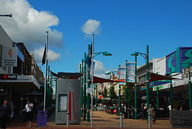
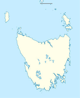
Devonport MallPopulation: 25,551 (2010)[1] Coordinates: 41°10′50″S 146°20′47″E / 41.18056°S 146.34639°ECoordinates: 41°10′50″S 146°20′47″E / 41.18056°S 146.34639°E Time zone: • Summer (DST)
AEST (UTC+10) AEDT (UTC+11)
Location: - 47 km (29 mi) from Burnie
- 98 km (61 mi) from Launceston
- 277 km (172 mi) from Hobart
LGA: City of Devonport State District: Braddon Federal Division: Braddon Devonport is a city in the northwestern part of Tasmania, Australia, situated at the mouth of the Mersey River. Along with the slightly smaller city of Burnie, Devonport is the major regional centre of the northwestern part of the state.
Contents
History
During the 1850s the twin settlements of Formby and Torquay were established on opposite banks at the mouth of the Mersey River. Torquay was the larger community with police, post, magistrate, at least three hotels, shipyards and stores. From 1870–1880 the shipping industry grew and work was undertaken to deepen the mouth of the river. When the mouth of the river could support a shipping industry the first regular steamer services commenced operating directly between the Mersey and Melbourne.
In 1889 the Bluff lighthouse was completed and the turn of the Century saw the railway make a significant difference to the Formby community. It combined a railhead and port facilities in the one place. A wharf was created on the west bank close to the railway and warehouses and situated in the main wharf area. The railway brought a building boom to Formby. In 1890 a public vote united Torquay and Formby, and the settlements became the town of Devonport.
Facilities
The main CBD is on the west side of the Mersey River and includes a pedestrian mall, cinema, speciality stores, chain stores and the Quality Gateway Hotel. Local restaurants include Bellas, Sharkies, Indian Affair and La Pisa. The former Devonport Hospital is now being considered to be transformed into over fifty apartments.
Government
Lyn Laycock was elected Mayor of the City of Devonport in 2005.[2] There are 12 aldermen that govern the Devonport City Council[3]
Transport
- Ferry Terminal
Devonport has the terminal for the Spirit of Tasmania ferries – Spirit I and II travel the 11 hours to Melbourne, Victoria.[4]
- Devonport Airport
Devonport Airport is located approximately 7 km to the east of the city of Devonport, about a 15 min drive by car. The airport is serviced by Bombardier Dash 8 aircraft, operated by QantasLink, with 4 daily services to Melbourne, Victoria. Tasair Regional Airlines operate daily passenger and freight services from Devonport to King Island.
There are several Bus companies serving Devonport including Mersey Link, Redline and Phoenix coaches.
Education
Primary Schools include Devonport Primary School, Miandetta Primary School, East Devonport Primary School, Nixon Street Primary School, Spreyton Primary School, Hillcrest Primary School, Devonport Christian School and Our Lady of Lourdes Catholic Primary School. Secondary schools include Devonport High School, Reece High School and St Brendan-Shaw College. Senior Secondary Education (Years 11–12) is provided by The Don College and St Brendan-Shaw College.
Climate
Devonport has mild to warm summers and cold winters with high humidity (about 70%) all year round. Most days from January to March average 20 °C to 25 °C with sunshine almost every day, the warmest and driest days can pass 30 °C but the humid air from the bass straight often prevents extreme heatwaves. Winters are more overcast with more rainfall with July and August been the wettest months of the year. September to December usually has overcast and windy weather.
Climate data for Devonport Airport Month Jan Feb Mar Apr May Jun Jul Aug Sep Oct Nov Dec Year Average high °C (°F) 21.2
(70.2)21.6
(70.9)20.3
(68.5)17.6
(63.7)15.3
(59.5)13.3
(55.9)12.7
(54.9)13.1
(55.6)14.1
(57.4)15.7
(60.3)17.5
(63.5)19.5
(67.1)16.8 Average low °C (°F) 12.2
(54.0)12.6
(54.7)10.8
(51.4)8.5
(47.3)6.8
(44.2)5.1
(41.2)4.6
(40.3)5.0
(41.0)6.0
(42.8)7.3
(45.1)9.0
(48.2)10.5
(50.9)8.2 Precipitation mm (inches) 41.5
(1.634)36.5
(1.437)45.7
(1.799)60.9
(2.398)74.4
(2.929)78.5
(3.091)96.7
(3.807)90.6
(3.567)74.5
(2.933)64.5
(2.539)56.6
(2.228)52.8
(2.079)773.0
(30.433)Source: Bureau of Meteorology[5] Sport
The Devonport Football Club is an Australian Rules team competing in the Tasmanian Statewide League. The Devonport Rugby Club[6] is a Rugby Union team competing in the Tasmanian Rugby Union Statewide League. Devonport City Football Club is a football (soccer) club which represents Devonport in the Tasmanian Northern Premier League.
The Devonport Athletic Club[7] hosts a leg of the Tasmaninan Cycling Christmas Carnival Series[8] each year in December attended by local and international cyclists, other sports at the carnivals include athletics and woodchopping. Woodchopping events are also held at the Devonport Agricultural & Pastoral Society Spring Show[9] in November. Local theatre and Conventions are held at the Devonport Entertainment and Convention Centre in the city's CBD
Sister cities
The city of Devonport has a formal sister city agreement with Minamata City in Japan. This was ratified in 1996. Both cities share a similar setting and area.
See also
References
- ^ "Estimated Resident Population". http://profile.id.com.au/Default.aspx?id=355&pg=210.
- ^ "Tasmanian Legislative Council 2009 Elections". abc.net.au. http://www.abc.net.au/elections/tas/2009/legislativecouncil/mersey.htm. Retrieved June 2009.
- ^ "Mayor and Aldermen". devonport.tas.gov.au. http://www.devonport.tas.gov.au/index.php?option=com_content&task=view&id=72&Itemid=82. Retrieved June 2009.
- ^ "Devonport to Melbourne Ferry Journey Length". http://www.travelaust.com/tasmania/ferry/devonport-melbourne/004. Retrieved 9 March 2011.
- ^ "Climate Data". BoM. http://www.bom.gov.au/climate/averages/tables/cw_091126.shtml. Retrieved 22 April 2010.
- ^ "Devonport Rugby Club". devonportbulls.rugbynet.com.au. http://devonportbulls.rugbynet.com.au/. Retrieved June 2009.
- ^ "Devonport Athletic Club". tas.cycling.org.au. http://www.tas.cycling.org.au/default.asp?Page=17482&MenuID=Affiliated_Clubs/20088/0/. Retrieved June 2009.
- ^ "Sports Carnival Association of Tasmania". tascarnivals.com. http://www.tascarnivals.com/. Retrieved June 2009.
- ^ "Agricultural Show Council of Tasmania". ascti.com.au. http://www.ascti.com.au/. Retrieved June 2009.
Cities of Australia Australian Capital Territory New South Wales Albury · Armidale · Bathurst · Broken Hill · Cessnock · Coffs Harbour · Dubbo · Gosford · Goulburn · Grafton · Griffith · Lake Macquarie · Lismore · Lithgow · Maitland · Newcastle · Nowra · Orange · Queanbeyan · Sydney · Tamworth · Wagga Wagga · WollongongNorthern Territory Queensland Brisbane · Bundaberg · Cairns · Caloundra · Gladstone · Gold Coast · Gympie · Hervey Bay · Mackay · Maryborough · Mount Isa · Rockhampton · Sunshine Coast · Toowoomba · TownsvilleSouth Australia Adelaide · Mount Gambier · Murray Bridge · Port Augusta · Port Lincoln · Port Pirie · Victor Harbor · WhyallaTasmania Victoria Western Australia Categories:- Port cities in Australia
- Cities in Tasmania
- Coastal cities in Australia
- Bass Strait ferries
- Devonport, Tasmania
- North West Tasmania
Wikimedia Foundation. 2010.


