- Hobart
Infobox Australian Place | type = city
name = Hobart
state = Tasmania
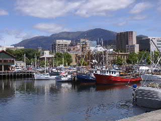
caption = Hobart downtown district and Mount Wellington viewed from Constitution Dock
pop = 205,566 (2006)cite news|url=http://www.abs.gov.au/AUSSTATS/abs@.nsf/2f762f95845417aeca25706c00834efa/5A717784C2562A99CA2573D20010FF17?opendocument|title=Geographic distribution of the population|author=Australian Bureau of Statistics |date=7 February 2008|accessdate=2008-03-26]
poprank = 11th
density = 895
density_footnotes = (2006) [cite web|url=http://abs.gov.au/websitedbs/d3310114.nsf/4a256353001af3ed4b2562bb00121564/45b3371f4a681356ca25740e007c92bf!OpenDocument|title=Explore Your City Through the 2006 Census Social Atlas Series|author=Australian Bureau of Statistics |date=17 March 2008|accessdate=2008-05-19]
area = 1357.3
est = 1803
timezone = AEST
utc = +10
timezone-dst= AEDT
utc-dst = +11
location1= New Norfolk
dist1=35
location2= Huonville
dist2=38
location3= Launceston
dist3=198
location4= Queenstown
dist4=248
location5= Burnie
dist5=297
landdistrict = Buckingham
stategov = Denison, Franklin
fedgov = Denison, Franklin
mintemp = 8.3
maxtemp = 16.9
rainfall = 619.5Hobart is the state capital and most populous city of the
Australia n island state ofTasmania . Founded in 1803 as apenal colony , [Frank Bolt, "The Founding of Hobart 1803-1804", ISBN 0 975 71660 3] it is one of Australia's oldest cities and the eleventh most populous, with a greater area population of approximately 205,566 in 2006. The city is the financial and administrative heart of Tasmania, and also serves as the home port for both Australian and French Antarctic operations.The city is located in the state's south-east on the estuary of the Derwent River. The skyline is dominated by Mount Wellington at 1,271 metres high.
History
The first settlement began in 1803 as a penal colony at
Risdon Cove on the eastern shores of the Derwent River, amid British concerns over the presence of Frenchexplorers . In 1804 it was moved to a better location at the present site of Hobart at Sullivan's Cove. The city, initially known as Hobart Town or Hobarton, was named after Lord Hobart, the Colonial Secretary. The area's original inhabitants were members of the semi-nomadicMouheneener tribe. [ [http://www.parliament.tas.gov.au/ha/So&Sessionals.htm Parliament of Tasmania - House of Assembly Standing Orders] "We acknowledge the traditional people of the land upon which we meet today, the Mouheneener people."] A series of bloody encounters with the Europeans and the effects of diseases brought by the settlers forced away the aboriginal population, which was rapidly replaced by free settlers and theconvict population.Charles Darwin visited Hobart Town in February, 1836 as part of the Beagle expedition. He writes of Hobart and the Derwent estuary in his "Voyage of the Beagle":...The lower parts of the hills which skirt the bay are cleared; and the bright yellow fields of corn, and dark green ones of potatoes, appear very luxuriant... I was chiefly struck with the comparative fewness of the large houses, either built or building. Hobart Town, from the census of 1835, contained 13,826 inhabitants, and the whole of Tasmania 36,505.
But since the Derwent River was one of Australia's finest deepwater ports and was the centre of the
Southern Ocean whaling and thesealing trade, it rapidly grew into a major port, with allied industries such as shipbuilding. Hobart Town became a city on 21 August 1842, and was renamed Hobart in 1875.Geography
Hobart is located on the estuary of the Derwent River in the state's south-east at coord|42|52|S|147|19|E|type:city(245,000)_region:AU-TAS. The
central business district is located on the western shore, adjacent to Sullivan's Cove, with the inner suburbs spread out along the shores of the Derwent and climbing up the hills at the foot of Mount Wellington. The Port of Hobart occupies the whole of the original Sullivan's Cove.The Greater Hobart Metropolitan area consists of three self-governing cities,
City of Hobart ,City of Glenorchy andCity of Clarence , plus the urbanised areas of theMunicipality of Kingborough andMunicipality of Brighton . The suburban areas cover a significant amount of both the western and eastern sides of the river. Apart from the city, the main commercial centres are Glenorchy (the "northern suburbs") and Rosny Park (the "eastern shore"). The satellite town Kingston, south of the city, is fast becoming an outlying suburb of Hobart. Other surrounding towns such as Sorell, Margate, Brighton and New Norfolk are popular residential areas for commuters.See also "List of Hobart suburbs "Climate
Hobart has a mild temperate
oceanic climate (Koppen "Cfb"), with four distinctseason s. The highest maximum temperature recorded was 40.8°C on 4 January 1976 and the lowest minimum was -2.8°C on 25 June 1972. Compared to other major Australia cities Hobart has the second least daily average hours of sunshine, with 5.9 hours. (Melbourne has the least) [www.bom.gov.au] The city rarely receives snow in winter; however, the adjacent Mount Wellington is often seen with a covering in winter, and it has received unseasonal snowfalls in all seasons, including summer. Hobart during the 20th century did receive many snowfalls at sea level because of cold air from Antarctica. These winds often carried on through Tasmania and Victoria until the winds reached theSnowy Mountains in New South Wales and Northern Victoria. Though snow isn't regular at sea level in Australia, Hobart has most probably had the most sea level snowfalls thoughSydney ,Melbourne andAdelaide have recorded at sea level. Mount Wellington has regular snowfalls through every season even summer because of the roaring forties which decides on the temperature of the mountain and the suburbs on the footstep of the mountain.:"See also:"
Infobox Weather
metric_first=yes
single_line=yes
location =Hobart
Jan_Hi_°C =21.6
Feb_Hi_°C =21.6
Mar_Hi_°C =20.1
Apr_Hi_°C =17.3
May_Hi_°C =14.4
Jun_Hi_°C =11.9
Jul_Hi_°C =11.6
Aug_Hi_°C =13.0
Sep_Hi_°C =15.0
Oct_Hi_°C =16.9
Nov_Hi_°C =18.7
Dec_Hi_°C =20.3
Year_Hi_°C =16.9
Jan_Lo_°C =11.8
Feb_Lo_°C =12.0
Mar_Lo_°C =10.8
Apr_Lo_°C =8.9
May_Lo_°C =6.9
Jun_Lo_°C =5.2
Jul_Lo_°C =4.5
Aug_Lo_°C =5.2
Sep_Lo_°C =6.4
Oct_Lo_°C =7.7
Nov_Lo_°C =9.2
Dec_Lo_°C =10.8
Year_Lo_°C =8.3
Jan_Precip_mm =48.0
Feb_Precip_mm =39.9
Mar_Precip_mm =45.2
Apr_Precip_mm =51.4
May_Precip_mm =46.8
Jun_Precip_mm =54.0
Jul_Precip_mm =52.5
Aug_Precip_mm =52.9
Sep_Precip_mm =52.7
Oct_Precip_mm =62.1
Nov_Precip_mm =53.7
Dec_Precip_mm =57.0
Year_Precip_mm =616.2
source =Bureau of Meteorologycite web
url=http://www.bom.gov.au/climate/averages/tables/cw_094029.shtml|title=Climate Data|accessmonthday=14 February|accessyear=2008
publisher=BoM|language=]
accessdate =1882-2008Infobox Weather
metric_first=yes
single_line=yes
location =Hobart Airport
Jan_Hi_°C =22.4
Feb_Hi_°C =22.3
Mar_Hi_°C =20.7
Apr_Hi_°C =18.1
May_Hi_°C =15.2
Jun_Hi_°C =12.9
Jul_Hi_°C =12.4
Aug_Hi_°C =13.4
Sep_Hi_°C =15.3
Oct_Hi_°C =17.3
Nov_Hi_°C =18.9
Dec_Hi_°C =20.6
Year_Hi_°C =17.5
Jan_Lo_°C =12.0
Feb_Lo_°C =12.0
Mar_Lo_°C =10.7
Apr_Lo_°C =8.7
May_Lo_°C =6.6
Jun_Lo_°C =4.6
Jul_Lo_°C =4.1
Aug_Lo_°C =4.6
Sep_Lo_°C =6.0
Oct_Lo_°C =7.5
Nov_Lo_°C =9.1
Dec_Lo_°C =10.7
Year_Lo_°C =8.0
Jan_Precip_mm =41.6
Feb_Precip_mm =36.6
Mar_Precip_mm =36.1
Apr_Precip_mm =43.0
May_Precip_mm =34.5
Jun_Precip_mm =30.1
Jul_Precip_mm =44.1
Aug_Precip_mm =46.8
Sep_Precip_mm =41.2
Oct_Precip_mm =47.7
Nov_Precip_mm =42.9
Dec_Precip_mm =54.2
Year_Precip_mm =498.6
source =Bureau of Meteorologycite web
url=http://www.bom.gov.au/climate/averages/tables/cw_094029.shtml|title=Climate Data|accessmonthday=14 February|accessyear=2008
publisher=BoM|language=]
accessdate =1882-2008Demographics
As of the 2006 census there were 200,525 people in the greater Hobart area Census 2006 AUS|id=605|name=Greater Hobart (Statistical Division)|accessdate=2007-09-27|quick=on] and the City of Hobart local government area has a population of 47,700. According to the 2006 census, approximately 12.0% of greater Hobart's residents were born overseas, commonly the
United Kingdom ,New Zealand ,Germany andNetherlands .Most common occupations are Professionals 21.6%, Clerical and Administrative Workers 16.1%, Technicians and Trades Workers 13.8%, Managers 11.5% and Community and Personal Service Workers 10.6%. Median weekly household income was $869, compared with $1,027 nationally.
In the 2006 census, 63.8% of residents specified a
Christian religion. Major religious affiliations areAnglican 29.8%,Catholic 21.1%,Uniting Church 4.2% andPresbyterian and Reformed 2.0%. In addition, 21.6% specified "No Religion" and 12.0% did not answer. [ [http://www.censusdata.abs.gov.au/ABSNavigation/download?format=xls&collection=Census&period=2006&productlabel=Religious%20Affiliation%20(broad%20groups)%20by%20Sex&producttype=Census%20Tables&method=Place%20of%20Usual%20Residence&areacode=605 Religious Affiliation (broad groups) by Sex - Greater Hobart] ]Economy
Hobart is a busy seaport, notably serving as the home port for the Antarctic activities of
Australia andFrance . The port loads around 2,000 tonnes of Antarctic cargo a year for the Australian research vessel "Aurora Australis." [cite news| last =Collyer |first =Sam |coauthors = |title =Potential Antarctic boost for Hobart port | work =Lloyd's List Daily Commercial News | pages = | publisher =Informa Australia Pty Ltd | date =2008-08-05 | url =http://www.lloydslistdcn.com.au/informaoz/LLDCN/news/daily-news/1217861971938/Potential-Antarctic-boost-for-Hobart-port.html | accessdate =2008-08-15 ]The city also supports several other industries, including a high-speed
catamaran factoryIncat and azinc smelter operated byNyrstar , as well as a vibrant tourist industry. Visitors come to the city to explore its historic inner suburbs, to visit the weekly craft market in Salamanca Place, as well as to use the city as a base from which to explore the rest ofTasmania .Other notable businesses in the area include the Cadbury chocolate factory and the
Cascade Brewery located in South Hobart near the natural spring waters of Mount Wellington. The Hobart surrounding area has many vineyards, includingMoorilla Estate at Berriedale.Development
* 12 Storey building that includes; car park, supermarket and offices. It's expected to cost between $50-55 million.
* Radical makeover of Hobart Waterfront.
* $290 million Myer and Cat and Fiddle Arcade development. (Development uncertain, because of Centro's collapse.)
* $300 million Canal and Quay development in the Eastern Shore suburb of Lauderdale (pending RPDC approval)Distinctive Features
The
Royal Tasmanian Botanical Gardens is a popular recreation area a short distance from the City centre. It is the second-oldest Botanic Gardens inAustralia and holds extensive significant plant collections as well as built heritage.Mount Wellington, accessible by passing through Fern Tree, is the dominant feature of Hobart's skyline, indeed many descriptions of Hobart have used the phrase "nestled amidst the foothills", so undulating is the geographical landscape. At 1,271 metres, the mountain has its own ecosystems, is rich in biodiversity and plays a large part in determining the local weather. An attempt to construct a cable car from the Cascade Brewery to the summit in the early 1990s was met with vocal disparagement, indicating just how important Hobartians consider "The Mountain".
The
Tasman Bridge is also a uniquely important feature of the city, connecting the two shores of Hobart and visible from many locations.Culture
Events
Hobart is internationally famous among the yachting community as the finish of the
Sydney to Hobart Yacht Race which starts inSydney on Boxing Day (the day after Christmas Day). The arrival of the yachts is celebrated as part of theHobart Summer Festival , a food and wine festival beginning just after Christmas and ending in mid-January. TheTaste of Tasmania is a major part of the festival, where locals and visitors can taste fine local and international food and wine.Hobart is the finish point of the
Targa Tasmania rally car event held annually in April since 1991.The annual
Tulip Festival at theRoyal Tasmanian Botanical Gardens is a popular Spring celebration in the City.The
Australian Wooden Boat Festival is a bi-annual event held inHobart celebratingwooden boats . It is held concurrently with theRoyal Hobart Regatta , which began in 1830 and is therefore Tasmania's oldest sporting event.Hobart also hosts the bulk of the
10 Days on the Island festival, a biannual international arts festival.Entertainment
Australia's first legal
casino was the 17-storeyWrest Point Hotel Casino in Sandy Bay, opened in 1973. It is still the tallest building in the city, despite being several kilometres out of the CBD, and is a nationally recognised icon.The Hobart nightlife primarily revolves around Salamanca Place, the waterfront area and Elizabeth St in North Hobart, but popular pubs, bars and
nightclub s exist around the city as well. Major national and international music events are usually held at theDerwent Entertainment Centre , or the Casino.Popular restaurant strips include Elizabeth Street in North Hobart, and Salamanca Place near the waterfront. These include a large number of ethnic restaurants including Chinese, Thai, Greek, Italian, Indian and Mexican.
Hobart is home to Australia's oldest theatre, the Theatre Royal. It also has three Village Cinema complexes, one each in the city, Glenorchy and Rosny. The State Cinema in North Hobart specializes in
arthouse and foreign films. [ [http://www.statecinema.com.au/ State Cinema] ]Hobart is home to the
Tasmanian Symphony Orchestra , which is resident at theFederation Concert Hall on the city's waterfront. It offers a year-round program of concerts and is thought to be one of the finest small orchestras in the world.Hobart also plays host to the University of Tasmania's acclaimed
Australian International Summer Orchestra Institute (AISOI) which brings pre-professional advanced young musicians to town from all over Australia and internationally. The AISOI plays host to a public concert season during the first two weeks of December every year focusing on large symphonic music. Like the Tasmanian Symphony Orchestra, the AISOI uses the Federation Concert Hall as its performing base.Hobart has also long been home to a thriving classical, jazz, folk, punk, hip-hop, electro, metal and rock music scene. Nationally recognised musicians such as singer/songwriters Michael Noga (of
The Drones ), two thirds of indie rock band Love Of Diagrams, Tim Evans (of bands Sea Scouts, Mouth andBird Blobs ),Monique Brumby , blues guitarist Phil Manning (of blues-rock bandChain ), power-pop group The Innocents and metal bandPsycroptic are all successful expatriates. In addition, founding member ofViolent Femmes ,Brian Ritchie , now calls Hobart home, and has formed a local band, The Green Mist.Several festivals such as the
Hobart Fringe Festival ,Hobart Summer Festival ,Southern Roots Festival ,Ten Days On The Island and theFalls Festival in Marion Bay all capitalise on the Hobart's artistic communities.Media
Hobart's major newspaper is "The Mercury", which was founded by John Davies in 1854 and has been continually published ever since. The paper is currently owned and operated by Rupert Murdoch's
News Limited .Six free-to-air television channels service Hobart. Commercial television channels are provided by
Southern Cross Tasmania ,Tasmanian Digital Television (TDT) andWIN Television . TheAustralian Broadcasting Corporation provides ABC1 andABC2 . Multicultural broadcaster SBS providesSBS Television .Until 1986, television broadcasts in the city were restricted to two channels:
TVT-6 and the ABC. In 1986, SBS began transmission to the city. In 1994 market aggregation allowed Launceston based stationTNT-9 (nowSouthern Cross Tasmania ) to broadcast to Hobart as well. TVT-6 (since known asTasTV , nowWIN Television ) took on aNine Network affiliation, with Southern Cross carrying both Seven and Ten programming. All stations commenced digital broadcasting during 2003, and in December 2003, a fifth station, TDT, began broadcasting. TDT is a joint venture between Southern Cross and WIN. In March 2005, ABC2 came on-line.Pay TV services are provided byAustar andSelecTV via satellite.Commercial radio stations licensed to cover the Hobart market include 7HO FM, Sea FM and
Heart 107.3 . Local community radio stations include Christian radio stationUltra106five , youth stationEdge Radio and92FM which targets the wider community with specialist programmes. All five ABC radio networks broadcast to Hobart via936 ABC Hobart ,Radio National ,Triple J ,Newsradio andABC Classic FM .port
Due to Tasmania's widely distributed population, most Hobart sporting teams in national competitions are statewide teams rather than exclusively city teams. These include the
Tasmanian Tigers cricket team, which plays home games atBellerive Oval on the eastern shore. Current Australian Cricket CaptainRicky Ponting 's Home Ground is Hobart, even though he was born in Launceston. DespiteAustralian rules football 's huge popularity in the state, Tasmania does not have a team in theAustralian Football League . It does, though, have a team (the Tasmanian Devils) in the VFL (Victorian league), and a team in the national league is a popular topic among supporters as well as the state government (one of the potential sponsors of such a team). Some AFL teams play scheduled games atAurora Stadium (atYork Park in Launceston) and occasionally atNorth Hobart Oval .Tasmania's small population and low sponsorship potential results in the state not being represented in national,
rugby union ,rugby league ,netball , soccer andbasketball leagues; although the OasisHobart Chargers do represent Hobart in theSouth East Australian Basketball League (SEABL). Also, there are bids lobbying for Tasmania to receive teams in the AFL and in theA-League .With boat registrations reportedly doubling in recent years, many residents follow the strong maritime history of the Island State by participating in a range of water sports including sailing and fishing.
Politics
Parliament House in Salamanca Place is a focal point for political activity in the state. The lawns outside Parliament House are frequently used for political protests.
Education
Hobart is home to the main campus of the
University of Tasmania , situated in Sandy Bay. On-site accommodation colleges include Christ College,Jane Franklin Hall and St John Fisher College. Other campuses are in Launceston and Burnie.Senior secondary colleges in the Hobart area include Hobart College, at the top of Mount Nelson just south of the city; inner-city Elizabeth College and St Michael's Collegiate School; The Friends' School in North Hobart; St Mary's College and
Guilford Young College in North Hobart;The Hutchins School andFahan School in Sandy Bay;Rosny College at Rosny on the eastern shore; andClaremont College at Claremont in the northern suburbs. Some of these colleges also function as community colleges, open to students outside the formal secondary school system. Many of these colleges are not exclusively colleges as they also provide primary and high school education.Transport
Most
public transport within the city is via an extensive network of Metro buses and some privatebus services. The main arterial routes within the urban area are theBrooker Highway to Glenorchy and the northern suburbs, theTasman Bridge andBowen Bridge across the river to Rosny and the Eastern Shore, and the Southern Outlet south to Kingston and theD'Entrecasteaux Channel .Leaving the city, motorists can travel the
Lyell Highway to the west coast, Midland Highway to Launceston and the north,Tasman Highway to the east coast, or theHuon Highway to the far south.Hobart is served by
Hobart International Airport , and the smallerCambridge Aerodrome (which mainly serves small charter airlines offering local tourist flights).Like many large cities, Hobart once operated passenger
tram services, aTrolleybus network consisting of six routes which operated until 1968. However, the tramway closed in the early 1960s. Suburban passenger trains, run by the Tasmanian Government Railways, closed in 1974 and the intrastate passenger service, the Tasman Limited, ceased in 1979.ee also
*
List of Tasmanians References
Further reading
*Bolt, Frank (2004) "The Founding of Hobart 1803 - 1804" Peregrine Pty Ltd, Kettering Tasmania. ISBN 0975716603
External links
* [http://www.hobartcity.com.au Hobart City Council]
*Satellite image from [http://maps.google.com/maps?q=hobart&ll=-42.88,147.35&spn=0.049270,0.098173&t=k&hl=en Google Maps]
*Street map from [http://www.whereis.com/whereis/mapping/renderMapAddress.do?name=&streetNumber=&street=City%20Center&streetType=&suburb=Hobart&state=Tasmania&latitude=-42.881&longitude=147.3265&navId=$01006046X0OL9$&brandId=1&advertiserId=&requiredZoomLevel=3 Whereis.com]
Wikimedia Foundation. 2010.