- Moorabool River
-
Moorabool River River 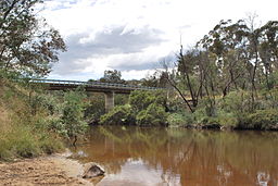
Country Australia State Victoria Tributaries - right Lal Lal Creek City Geelong Landmark Lal Lal Reservoir Source Moorabool Reservoir, near Ballarat - coordinates 37°30′33″S 144°5′0″E / 37.50917°S 144.083333°E Mouth confluence with Barwon River at Fyansford - coordinates 38°8′39″S 144°18′54″E / 38.14417°S 144.315°E Wikimedia Commons: Moorabool River The Moorabool River is a river in Victoria, Australia that runs past several small towns and areas such as Meredith, Anakie, and Staughton Vale (north-west of Geelong). The river joins with the Barwon River at Fyansford.
Contents
Bridges
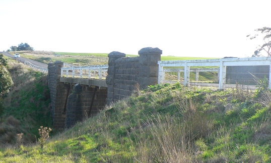
 Bluestone bridge over the Moorabool on Yendon-Egerton Road
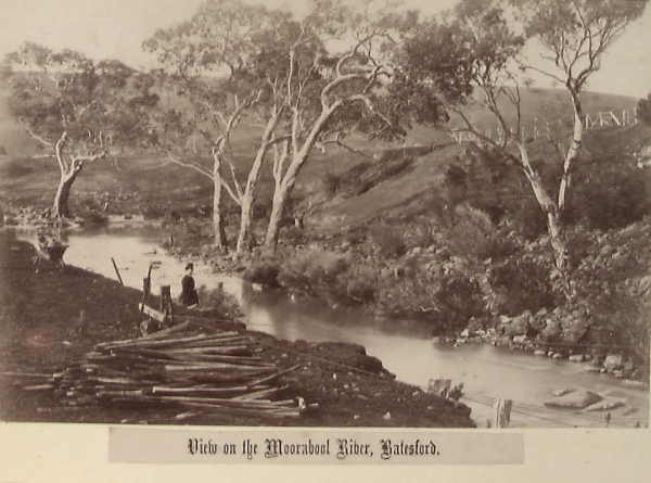
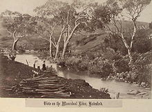 The Moorabool River, at Batesford, 1882
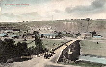 Bridge at Fyansford, 1908
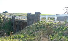
The river features several historic bridges, many built in colonial bluestone.
Batesford Bridge
Batesford was originally the site of a ford over the Moorabool River.
The first bridge at Batesford was built by the Corio and Bannockburn shire councils in 1846. Provided with a tollgate, the wooden bridge was located upstream from the ford, and collapsed in 1847. It was again rebuilt in wood in 1848, and was damaged by flood in 1852 and later repaired. A bluestone bridge was built in 1859, which still exists today as a service road. The current concrete bridge of the Midland Highway was built in 1972 on a new alignment.[1]
Fyansford Bridge
The first river crossing at Fyansford was again a ford.
The first wooden bridge was built downriver from the ford by the Shire of Corio and Shire of Bannockburn in 1854, and was tolled until 1877. It was in poor condition by 1898, with load restrictions being put into place. A new bridge was built nearby in 1900 by John Monash and J. T. N. Anderson, the three arch bridge being the largest Monier reinforced concrete bridge in world at the time.[1]
In 1970 a new bridge was built on the site of the old wooden bridge to cater for heavier traffic on the Hamilton Highway, the 1900 bridge retained for pedestrians.[1]
Geelong Ring Road
Work on the Geelong Ring Road bridge commenced in late 2006. Costing $15.5 million,[2] it carries four lanes of traffic and is the largest bridge on the road featuring 70 beams and 12 piers. The final span was installed on March 6, 2008.[3] It has since been named the Lewis Bandt Bridge.[4]
Moorabool Viaduct
The 1450 feet (442 metres) long bluestone and iron Moorabool Viaduct was opened in 1862 to carry the Geelong-Ballarat railway over the river valley. It remains in use today, having been rebuilt in steel in 1918 to a design of Victorian Railways engineer Frederick Esling.[5][6]
References
- ^ a b c John, McNeil (1990) A Journey to Destiny 1890-1990 100 Years of Cement Manufacturing at Fyansford by Australian Cement Limited
- ^ "GEELONG BYPASS SECTION 2 OFFICIALLY LAUNCHED". Media Release: MINISTER FOR PUBLIC TRANSPORT. www.legislation.vic.gov.au. September 27, 2006. http://www.legislation.vic.gov.au/domino/Web_Notes/newmedia.nsf/bc348d5912436a9cca256cfc0082d800/743b36e641bac878ca2571f700037588!OpenDocument. Retrieved 2008-07-18.
- ^ Jeff Whalley (March 7, 2008). "MPs crane their necks to see the ring road milestone". Geelong Advertiser. www.geelongadvertiser.com.au. http://www.geelongadvertiser.com.au/article/2008/03/07/11977_news.html. Retrieved 2008-07-18.
- ^ "Brumby Declares Geelong Ring Road Open". Geelong Advertiser. 2008-12-14. http://www.geelongadvertiser.com.au/article/2008/12/14/37395_news.html. Retrieved 2009-04-16.
- ^ "Rail Geelong - Geelong Line Guide". www.railgeelong.com. http://www.railgeelong.com/lineguide/geelong. Retrieved 2008-04-23.
- ^ "Rail Geelong - Gallery - Moorabool Viaduct". www.railgeelong.com. http://www.railgeelong.com/gallery/geelong-ballarat/moorabool-viaduct. Retrieved 2009-09-05.
External links
- Corangamite Catchment Management Authority
- Moorabool River at BIRD (wiki)
- People for A Living Moorabool
Rivers of Victoria Rivers flowing towards the coast Agnes · Aire · Albert · Anglesea · Avon · Barham · Barwon · Bass · Bemm · Benedore · Betka · Brodribb · Bunyip · Calder · Cann · Cumberland · Darby · Dargo · Elliott · Eumeralla · Fitzroy · Ford · Franklin · Geary · Gellibrand · Glenelg · Grey · Hartland · Hopkins · Jamieson · Johanna · Jordan · Kennett · Lang Lang · La Trobe · Lerderderg · Little · Little Yarra · Macalister · Maribyrnong · Merri · Mitchell · Moorabool · Morwell · Moyne · Mueller · Nicholson · O'Shannassy · Parker · Patterson · Perry · Plenty · Powlett · Red · St George · Shaw · Snowy · Surry · Tambo · Tarra · Tarwin · Thomson · Thurra · Tidal · Timbarra · Wannon · Watts · Wentworth · Werribee · Wingan · Woady Yaloak · Wye · Yarra · Yarrowee · YeerungRivers of the Murray basin Rivers draining inland Categories:- Geography of Geelong
- Rivers of Victoria (Australia)


Wikimedia Foundation. 2010.