Shire of Corio

Shire of Corio

Infobox Australian Place | type = lga
name = Shire of Corio
state = vic
region =
area = 704.66
est = 1861
seat = Geelong North
pop = 57,720 (1992) [cite book|title=Victorian Year Book|author=Australian Bureau of Statistics, Victoria Office|year=1994|page=49-52|id=ISSN 0067-1223]

logosize =


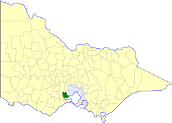
caption = Location in Victoria
county = Grant
near-nw = Ballan
near-n = Bacchus Marsh
near-ne = Werribee
near-w = Bannockburn
near-e = Werribee
near-sw = Bannockburn
near-s = Geelong
near-se = "Corio Bay"
_noautocat = yes

The Shire of Corio was a Local Government Area located between Geelong and Werribee about convert|60|km|mi|0 southwest of Melbourne, the state capital of Victoria, Australia. The shire, which included all of Geelong's northern suburbs, covered an area of convert|704.66|km2|sqmi|1, and existed from 1861 until 1993.

History

Corio was first incorporated as a district on 3 April 1861, and became a shire on 21 June 1864. Part of the Lara Riding was lost to Shire of Bacchus Marsh on 15 March 1911, but the same riding gained part of the Shire of Bannockburn on 31 May 1916. The Moorpanyal riding transferred to the City of Geelong West on 9 December 1926, becoming its West Ward.cite book|title=Victorian Municipal Directory|year=1992|publisher=Arnall & Jackson|location=Brunswick|pages=636-637 Accessed at State Library of Victoria, La Trobe Reading Room.]

On 18 May 1993, the Shire was abolished, and merged with Cities of Geelong, Geelong West and Newtown, Rural City of Bellarine, part of the City of South Barwon and parts of the Shires of Barrabool and Bannockburn into the City of Greater Geelong.

Wards

Corio was divided into four ridings, each of which elected three councillors:
* Flinders Riding
* Hovell Riding
* Hume Riding
* Peak Riding

Towns and Localities

Population

* Estimate in 1958 Victorian Year Book.

References


Wikimedia Foundation. 2010.

Игры ⚽ Нужна курсовая?

Look at other dictionaries:

  • Shire of Bannockburn — Infobox Australian Place | type = lga name = Shire of Bannockburn state = vic region = area = 702.28 est = 1862 seat = Bannockburn pop = 4,560 (1992) [cite book|title=Victorian Year Book|author=Australian Bureau of Statistics, Victoria… …   Wikipedia

  • Shire of Bacchus Marsh — Infobox Australian Place | type = lga name = Shire of Bacchus Marsh state = vic region = area = 565 est = 1862 seat = Bacchus Marsh pop = 12,590 (1992) [cite book|title=Victorian Year Book|author=Australian Bureau of Statistics, Victoria… …   Wikipedia

  • Shire of Ballan — Infobox Australian Place | type = lga name = Shire of Ballan state = vic region = area = 919.45 est = 1862 seat = Ballan pop = 4,900 (1992) [cite book|title=Victorian Year Book|author=Australian Bureau of Statistics, Victoria… …   Wikipedia

  • City of Greater Geelong — This article is about a local government area. For the city centre of Geelong, see Geelong city centre, Victoria. City of Greater Geelong Victoria …   Wikipedia

  • Osborne House (Geelong) — Coordinates: 38°07′10″S 144°21′29″E / 38.11945°S 144.35795°E / 38.11945; 144.35795 …   Wikipedia

  • City of Geelong West — Victoria Location in Victoria Population: 13630 (1992)[1 …   Wikipedia

  • Rural City of Bellarine — Infobox Australian Place | type = lga name = Rural City of Bellarine state = vic region = area = 331.78 est = 1853 seat = Drysdale pop = 44,180 (1992) [cite book|title=Victorian Year Book|author=Australian Bureau of Statistics, Victoria… …   Wikipedia

  • Moorabool River — Coordinates: 38°8′39″S 144°18′54″E / 38.14417°S 144.315°E / 38.14417; 144.315 …   Wikipedia

  • City of Geelong — This article is about the Local Government Area. For the city of the same name, see Geelong, Victoria. City of Geelong Victoria Location in Victoria P …   Wikipedia

  • City of Newtown — Victoria Location in Victoria Population: 10210 (1992)[1] …   Wikipedia

Share the article and excerpts

Direct link
Do a right-click on the link above
and select “Copy Link”