- Shire of Buninyong
Infobox Australian Place | type = lga
name = Shire of Buninyong
state = vic
region =
area = 785.1
est = 1858
seat = Buninyong
pop = 12,760 (1992) [cite book|title=Victorian Year Book|author=Australian Bureau of Statistics, Victoria Office|year=1994|page=49-52|id=ISSN 0067-1223]
logosize =
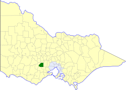
caption = Location in Victoria
county = Grenville, Grant
near-nw = Ballaarat
near-n = Bungaree
near-ne = Bungaree
near-w = Grenville
near-e = Ballan
near-sw = Grenville
near-s = Leigh
near-se = Bannockburn
_noautocat = yesThe Shire of Buninyong was a Local Government Area located south and southeast of the regional city of Ballarat, Victoria,
Australia . The shire covered an area of convert|785.1|km2|sqmi|1, and existed from 1858 until 1994.History
Buninyong was first incorporated as a district on 9 July 1858, and became a shire on 18 February 1864. On 1 October 1915, it absorbed the Borough of Buninyong, which had been created on 15 July 1859.cite book|title=Victorian Municipal Directory|year=1992|publisher=Arnall & Jackson|location=Brunswick|pages=623-625 Accessed at
State Library of Victoria , La Trobe Reading Room.]On 6 May 1994, the Shire was abolished, and split between the
City of Ballarat and theShire of Moorabool . A small section near Grenville was added to theGolden Plains Shire .Wards
Buninyong was divided into three ridings , each of which elected three councillors:
* Centre Riding
* West Riding
* Northeast RidingTowns and Localities
* Buninyong
* Cambrian Hill
* Canadian
* Clarendon
* Dunnstown
* Durham Lead
* Elaine
* Grenville
* Lal Lal
* Magpie
* Millbrook
* Mount Clear
* Mount Helen
* Scotchman
* Warrenheip
* YendonPopulation
* Estimate in 1958 Victorian Year Book.
References
Wikimedia Foundation. 2010.