- Coliban River
-
Coliban River 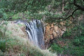
Trentham Falls in the upper stretches of the RiverOrigin Great Dividing Range Mouth Lake Eppalock Basin countries Australia The Coliban River is a river in central Victoria, in Australia. It is a major water supply source for towns and cities in the region.
Contents
Course
The river begins at the Great Dividing Range near Lyonville and plunges 33 metres at Trentham Falls, flowing northward to the Upper Coliban, Lauriston and Malmsbury reservoirs. Subsequently it flows through Malmsbury and Metcalfe and finally meets the Campaspe River at Lake Eppalock.[1]
Water Supply
Gold was found in the river in 1858, and water from the river was used to supply the goldfields cities of Bendigo and Castlemaine. As the population of those cities grew a water supply system consisting of 70 kilometres of tunnels and aqueducts was constructed. Over time, the water supply was extended to Kyneton, as well as many other smaller towns in the region. Today the system supplies drinking water to a population exceeding 200,000.[1]
Fauna and flora
The river is home to the platypus as well as eight native fish species including the Macquarie perch. Four of the fish species are endangered and the trout cod is regarded as critically endangered in the river, and may no longer be present. Indigenous vegetation in the area includes the black gum (Eucalyptus aggregata) which, though once plentiful in the area, is now rare due to vegetation clearance over many years.[1]
Management
The Coliban Region Water Corporation (Coliban Water) manages the three major water supply reservoirs, which are part of the Eppalock Proclaimed Water Supply Catchment.[2]
References
- ^ a b c "Your River: The Coliban - River Recovery". Greening Australia. http://www.coliban.com.au. Retrieved 2008-01-19.
- ^ "Coliban Water". Coliban Water. http://www.coliban.com.au. Retrieved 2008-01-19.
External links
- Public Record Office Victoria Photograph of Victorian Railways passenger train crossing the viaduct over the Coliban River at Malmsbury, November 1945.
Coordinates: 36°56′S 144°33′E / 36.933°S 144.55°E
Rivers of Victoria Rivers flowing towards the coast Agnes · Aire · Albert · Anglesea · Avon · Barham · Barwon · Bass · Bemm · Benedore · Betka · Brodribb · Bunyip · Calder · Cann · Cumberland · Darby · Dargo · Elliott · Eumeralla · Fitzroy · Ford · Franklin · Geary · Gellibrand · Glenelg · Grey · Hartland · Hopkins · Jamieson · Johanna · Jordan · Kennett · Lang Lang · La Trobe · Lerderderg · Little · Little Yarra · Macalister · Maribyrnong · Merri · Mitchell · Moorabool · Morwell · Moyne · Mueller · Nicholson · O'Shannassy · Parker · Patterson · Perry · Plenty · Powlett · Red · St George · Shaw · Snowy · Surry · Tambo · Tarra · Tarwin · Thomson · Thurra · Tidal · Timbarra · Wannon · Watts · Wentworth · Werribee · Wingan · Woady Yaloak · Wye · Yarra · Yarrowee · YeerungRivers of the Murray basin Rivers draining inland Categories:- Rivers of Victoria (Australia)
- Murray-Darling basin

Wikimedia Foundation. 2010.