- Camperdown, Victoria
Infobox Australian Place | type = town
name = Camperdown
state = Victoria

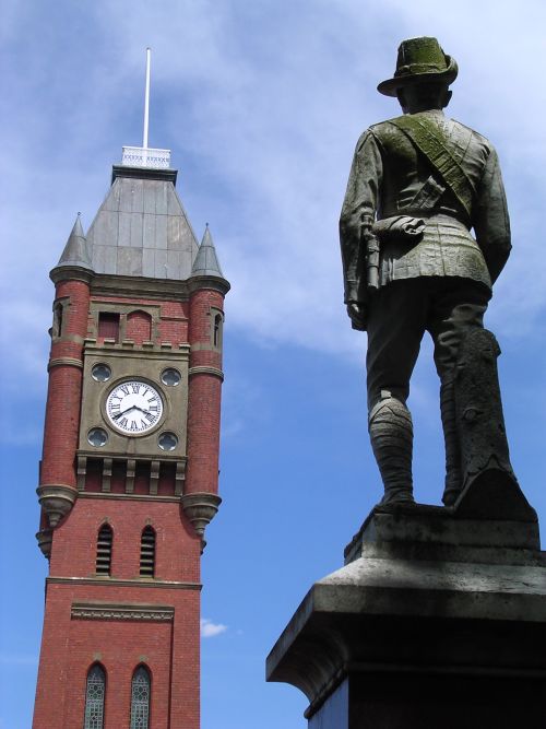
caption = Camperdown clock tower and war memorial.
lga = Corangamite Shire
postcode = 3260
est = 1854
pop = 3541 (2006)Census 2006 AUS | id = SSC25291 | name = Camperdown (State Suburb) | accessdate = 2007-10-01 | quick = on]
elevation= 165
maxtemp = 19.1
mintemp = 8.1
rainfall = 762.4
stategov = Polwarth
fedgov = Wannon
dist1 = 194
dir1 = SW
location1= Melbourne
dist2 = 45
dir2 = W
location2= ColacCamperdown is an historically significant rural town in western Victoria,
Australia , 194 kilometres (121 mi) km south west of the state capital,Melbourne . At the 2006 census, Camperdown had a population of 3541.History
The town was surveyed in 1851 and named Camperdown after a Scottish Naval hero (the
Earl of Camperdown ). The first dwelling was erected on the site of the present Commercial Hotel in 1853 Citationlast = Gatewaybbs | title = Camperdown Attractions | url = http://www.gatewaybbs.com.au/Campdown/Attract.htm | accessdate = 2008-07-21] and the Post Office opened on
January 1 ,1854 replacing an earlier one in the area named Timboon.Citationlast = Premier Postal History | title = Post Office List | url = https://www.premierpostal.com/cgi-bin/wsProd.sh/Viewpocdwrapper.p?SortBy=VIC&country=| accessdate = 2008-04-11]
It became the service centre for the vast pastoral empires of the region. The railway through the town was opened in 1883,cite journal
year = 1990
month = March
title = Tracks Across the State
author = Sid Brown
journal = Newsrail
publisher = Australian Railway Historical Society (Victorian Division)
pages = pages 71–76 ] and later extended as part of the line to the south west of the state. The local railway station is served byV/Line passenger services on the Warrnambool line.By the mid 20th century Camperdown had emerged as a more diverse centre for dairy farming which drew on its rich volcanic soil, for woolgrowing and for produce processing industries. By the late 20th century the town had become a major centre for tourism because of its unspoiled 19th century architecture and as a gateway to the southern tourist attractions of the
Otway Ranges , theGreat Ocean Road and the 'Shipwreck Coast '.Geography
Camperdown lies within the 'Lakes and Craters' region, sitting at the foot of Mount Leura which together with nearby Mount Sugarloaf are part of a large extinct volcanic complex known as the "Leura
Maar ".Citation
last = Department of Primary Industry | title = Corangamite | url = http://www.dpi.vic.gov.au/DPI/Vro/coranregn.nsf/pages/corangamite_eruption_points_leura | accessdate = 2008-07-21] To the immediate west are the deep volcaniccrater lake s Bullen-Merri and Gnotuk while to the east is the craterlake Purrumbete popular for itsTrout andChinook Salmon fishing.Features
The town is renowned for its classic historical buildings. Central is the convert|103|ft|m|sing=on high Gothic Manifold Clock Tower, built 1897, which sits in a wide
Elm lined median between the dual carriageways of Manifold Street, named in honour of one of the pioneer pastoralists. Tower, avenue, Boer War memorial, Soldiers' memorial, memorial cross and JC Manifold statue are all listed on theVictorian Heritage Register .Among the many other classic buildings are the 1886-7 two storey Georgian style Court House, the 1863 two storey bluestone (
granite ) Post Office, Theatre Royal (1890) and Masonic Hall (1867-68).Community
The town has an
Australian Rules football team playing in theHampden Football League .Citationlast = Full Point Footy | title = Camperdown | url = http://www.fullpointsfooty.net/Camperdown.htm | accessdate = 2008-07-25 ]
ee also
References
* Victorian Heritage Register, Heritage Victoria
External links
* [http://web.archive.org/web/20040511090651/www.arts.monash.edu.au/ncas/multimedia/gazetteer/list/camperdown.html Australian Places - Camperdown]
Wikimedia Foundation. 2010.
