- Coeburn, Virginia
-
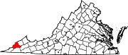
Coeburn, Virginia — Town — Location of Coeburn, Virginia
Coordinates: 36°56′38″N 82°27′58″W / 36.94389°N 82.46611°WCoordinates: 36°56′38″N 82°27′58″W / 36.94389°N 82.46611°W Country United States State Virginia County Wise Area – Total 2.0 sq mi (5.3 km2) – Land 2.0 sq mi (5.3 km2) – Water 0.0 sq mi (0.0 km2) Elevation 1,995 ft (608 m) Population (2000) – Total 1,996 – Density 973.8/sq mi (376.0/km2) Time zone Eastern (EST) (UTC-5) – Summer (DST) EDT (UTC-4) ZIP code 24230 Area code(s) 276 FIPS code 51-17952[1] GNIS feature ID 1482614[2] Coeburn is a town in Wise County, Virginia, along the Guest River. The population was 1,996 at the 2000 census with many small peaceful wooded communities in the outskirts. Camping is available nearby at Bark Camp Lake in the Jefferson National Forest with other activities including boating and fishing. Coeburn also has a racetrack and has many trails for riding 4-wheelers. The Guest River Gorge Trail, built along the Guest River on what was formerly the Interstate Railroad is also located in the Jefferson National Forest and is a popular place to walk or ride a bicycle.
Contents
Geography
Coeburn is located at 36°56′38″N 82°27′58″W / 36.943872°N 82.466069°W (36.943872, -82.466069).[3]
According to the United States Census Bureau, the town has a total area of 2.0 square miles (5.3 km2), all of it land. Coeburn has many mountains and hills.
Demographics
As of the census[1] of 2000, there were 1,996 people, 810 households, and 575 families residing in the town. The population density was 973.8 people per square mile (375.9/km2). There were 923 housing units at an average density of 450.3 per square mile (173.8/km2). The racial makeup of the town was 95.29% White, 2.81% African American, 0.20% Native American, 0.10% Asian, 0.05% Pacific Islander, 0.05% from other races, and 1.50% from two or more races. Hispanic or Latino of any race were 0.60% of the population.
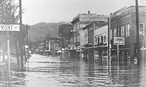 Flood in Coeburn in 1963
There were 810 households out of which 29.6% had children under the age of 18 living with them, 50.2% were married couples living together, 16.3% had a female householder with no husband present, and 28.9% were non-families. 26.0% of all households were made up of individuals and 11.6% had someone living alone who was 65 years of age or older. The average household size was 2.44 and the average family size was 2.92.
In the town the population was spread out with 22.5% under the age of 18, 9.4% from 18 to 24, 28.6% from 25 to 44, 23.9% from 45 to 64, and 15.6% who were 65 years of age or older. The median age was 39 years. For every 100 females there were 93.4 males. For every 100 females age 18 and over, there were 90.5 males.
The median income for a household in the town was $25,025, and the median income for a family was $28,929. The per capita income for the town was $12,802. About 17.0% of families and 20.5% of the population were below the poverty line, including 29.9% of those under age 18 and 7.8% of those age 65 or over.
Education
Coeburn is home to three public schools: Coeburn Primary, Coeburn Middle, and Eastside High. [1]
Notable residents
- Holly Kiser - Make Me a Supermodel winner.
- Jesse McReynolds - Bluegrass Musician.
- Danny O'Quinn Jr. - Professional stock car racer.
- Tracy Stallard - Baseball Player.
- Ralph Stanley - Bluegrass Musician.
References
- ^ a b "American FactFinder". United States Census Bureau. http://factfinder.census.gov. Retrieved 2008-01-31.
- ^ "US Board on Geographic Names". United States Geological Survey. 2007-10-25. http://geonames.usgs.gov. Retrieved 2008-01-31.
- ^ "US Gazetteer files: 2010, 2000, and 1990". United States Census Bureau. 2011-02-12. http://www.census.gov/geo/www/gazetteer/gazette.html. Retrieved 2011-04-23.
External links
Municipalities and communities of Wise County, Virginia Towns Appalachia | Big Stone Gap | Coeburn | Pound | St. Paul‡ | Wise
CDP Riverview
Footnotes ‡This populated place also has portions in an adjacent county or counties
 Commonwealth of Virginia
Topics - Climate
- Colleges and universities
- Colony
- Congressional Districts
- Culture
- Delegations
- Demographics
- Economy
- Education
- Environment
- Furniture
- Geography
- Government
- Governors
- History
- Historic Landmarks
- Magisterial Districts
- Homes
- Music
- People
- Police
- Politics
- Rights
- Rivers
- School divisions
- Scouting
- Slogan
- Sports teams
- State Fair
- State parks
- Symbols
- Towns
- Transportation
- Tribes
- Visitor Attractions
Regions - Allegheny Mountains
- Atlantic Coastal Plain
- Blue Ridge
- Chesapeake Bay
- Cumberland Mountains
- Delmarva Peninsula
- Eastern Shore
- Hampton Roads
- Middle Peninsula
- Northern Neck
- Northern Virginia
- Piedmont
- Ridge-and-Valley Appalachians
- Shenandoah Valley
- South Hampton Roads
- Southside
- Southwest Virginia
- Tennessee Valley
- Tidewater
- Tri-Cities
- Virginia Peninsula
Metro areas - Blacksburg-Christiansburg-Radford
- Bluefield
- Bristol
- Charlottesville
- Culpeper
- Danville
- Fredericksburg
- Harrisonburg
- Lynchburg
- Martinsville
- Richmond
- Roanoke
- Staunton
- Hampton Roads
- Washington-Arlington-Alexandria
- Waynesboro
- Winchester
Counties - Accomack
- Albemarle
- Alleghany
- Amelia
- Amherst
- Appomattox
- Arlington
- Augusta
- Bath
- Bedford
- Bland
- Botetourt
- Brunswick
- Buchanan
- Buckingham
- Campbell
- Caroline
- Carroll
- Charles City
- Charlotte
- Chesterfield
- Clarke
- Craig
- Culpeper
- Cumberland
- Dickenson
- Dinwiddie
- Essex
- Fairfax
- Fauquier
- Floyd
- Fluvanna
- Franklin
- Frederick
- Giles
- Gloucester
- Goochland
- Grayson
- Greene
- Greensville
- Halifax
- Hanover
- Henrico
- Henry
- Highland
- Isle of Wight
- James City
- King and Queen
- King George
- King William
- Lancaster
- Lee
- Loudoun
- Louisa
- Lunenburg
- Madison
- Mathews
- Mecklenburg
- Middlesex
- Montgomery
- Nelson
- New Kent
- Northampton
- Northumberland
- Nottoway
- Orange
- Page
- Patrick
- Pittsylvania
- Powhatan
- Prince Edward
- Prince George
- Prince William
- Pulaski
- Rappahannock
- Richmond
- Roanoke
- Rockbridge
- Rockingham
- Russell
- Scott
- Shenandoah
- Smyth
- Southampton
- Spotsylvania
- Stafford
- Surry
- Sussex
- Tazewell
- Warren
- Washington
- Westmoreland
- Wise
- Wythe
- York
Independent
cities- Alexandria
- Bedford
- Bristol
- Buena Vista
- Charlottesville
- Chesapeake
- Colonial Heights
- Covington
- Danville
- Emporia
- Fairfax
- Falls Church
- Franklin
- Fredericksburg
- Galax
- Hampton
- Harrisonburg
- Hopewell
- Lexington
- Lynchburg
- Manassas
- Manassas Park
- Martinsville
- Newport News
- Norfolk
- Norton
- Petersburg
- Poquoson
- Portsmouth
- Radford
- Richmond
- Roanoke
- Salem
- Staunton
- Suffolk
- Virginia Beach
- Waynesboro
- Williamsburg
- Winchester
Categories:- Towns in Virginia
- Populated places in Wise County, Virginia


Wikimedia Foundation. 2010.