- Occoquan, Virginia
-
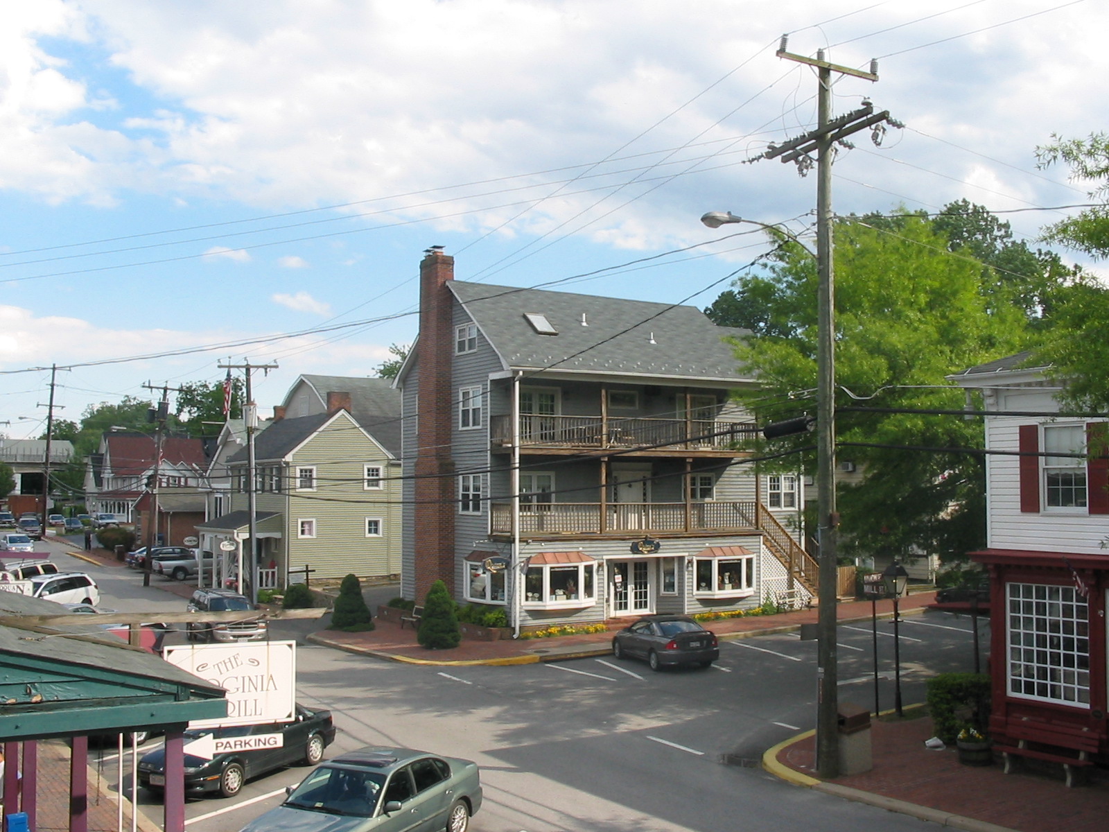
Occoquan, Virginia — Town — Mill Street, the center of Occoquan's historic and commercial district Location of Occoquan, Virginia
Coordinates: 38°40′58″N 77°15′39″W / 38.68278°N 77.26083°WCoordinates: 38°40′58″N 77°15′39″W / 38.68278°N 77.26083°W Country United States State Virginia Counties Prince William[1] Area – Total 0.2 sq mi (0.5 km2) – Land 0.2 sq mi (0.4 km2) – Water 0.0 sq mi (0.1 km2) Elevation 7 ft (2 m) Population (2000) – Total 759 – Density 4,868.7/sq mi (1,879.8/km2) Time zone Eastern (EST) (UTC-5) – Summer (DST) EDT (UTC-4) ZIP code 22125 Area code(s) 703, 571 FIPS code 51-58696[2] GNIS feature ID 1497059[3] Website http://www.occoquan.org/ Occoquan is a town in Prince William County in the U.S. state of Virginia. The population was 759 at the 2000 census, but as of the census of 2010, there were 934 people residing in the town of Occoquan. The town is a suburb of Washington, D.C. and is adjacent to Woodbridge. The current mayor is Earnest "Earnie" Porta, who was first elected in 2006, and won re-election in 2008.
Contents
History
Occoquan is derived from an Algonquian Doeg Indian word, meaning "at the end of the water". Located on the Occoquan River, Occoquan was long a site of indigenous peoples' habitation. Like the British colonists after them, they relied on the river for transportation and trade, as well as fish.
By 1765, Anglo-American colonists had established an industrial settlement at Occoquan, with grist mills and tobacco warehouses. The Merchant's Mill was the first automated grist mill in the nation. It operated for 175 years until destroyed by fire.
During the Civil War, the post office passed letters and packages between North and South. River silting reduced ship traffic to Occoquan and ended its days as a port, as did the shift in traffic to railroads.
The town has survived and thrived. Today, it is a restored artists' community, with shops, outdoor dining, ghost walks, a town boat dock and more. A number of structures in town, including many in the downtown commercial area, are part of the Occoquan Historic District listed on the National Register of Historic Places (NRHP). Rockledge, the former house of the town's founder, is also listed as a significant structure on the NRHP.
Geography
Occoquan is located at 38°40′58″N 77°15′39″W / 38.68278°N 77.26083°W (38.682916, -77.260830)[4].
According to the United States Census Bureau, the town has a total area of 0.2 square mile (0.5 km²) of which, 0.2 square mile (0.4 km²) is land and 0.04 square mile (0.1 km²) (15.79%) is water.
Occoquan lies on the south bank of the Occoquan River at the fall line.
Demographics
As of the census[2] of 2000, there were 759 people, 418 households, and 186 families residing in the town. The population density was 4,868.7 people per square mile (1,831.6/km²). There were 443 housing units at an average density of 2,841.7 per square mile (1,069.0/km²). The racial makeup of the town was 85.51% White, 8.17% Black, 0.53% Native American, 1.58% Asian, 0.13% Pacific Islander, 1.58% from other races, and 2.50% from two or more races. Hispanic or Latino of any race were 6.46% of the population.
There were 418 households out of which 11.5% had children under the age of 18 living with them, 35.6% were married couples living together, 6.2% had a female householder with no husband present, and 55.3% were non-families. 45.9% of all households were made up of individuals and 8.1% had someone living alone who was 65 years of age or older. The average household size was 1.82 and the average family size was 2.54.
 The Occoquan River as it passes the town
In the town the population was spread out with 11.1% under the age of 18, 8.0% from 18 to 24, 36.2% from 25 to 44, 33.6% from 45 to 64, and 11.1% who were 65 years of age or older. The median age was 42 years. For every 100 females there were 88.8 males. For every 100 females age 18 and over, there were 92.3 males.
The median income for a household in the town was $48,750, and the median income for a family was $77,420. Males had a median income of $50,938 versus $30,833 for females. The per capita income for the town was $33,007. None of the families and 5.7% of the population were living below the poverty line, including no under eighteens and 14.9% of those over 64.
As of the census of 2010, there were 934 people residing in the town of Occoquan.[citation needed]
References
- ^ "Charter of Town of Occoquan". Virginia Division of Legislative Services. http://dls.state.va.us/lrc/charters/OCCOQUAN.pdf. Retrieved 2009-06-14.
- ^ a b "American FactFinder". United States Census Bureau. http://factfinder.census.gov. Retrieved 2008-01-31.
- ^ "US Board on Geographic Names". United States Geological Survey. 2007-10-25. http://geonames.usgs.gov. Retrieved 2008-01-31.
- ^ "US Gazetteer files: 2010, 2000, and 1990". United States Census Bureau. 2011-02-12. http://www.census.gov/geo/www/gazetteer/gazette.html. Retrieved 2011-04-23.
External links
- Town of Occoquan
- Prince William County Government
- OccoquanWaterfront: A blog about living and boating in Historic Occoquan
- Historic Occoquan shopping, dining, and event information
- Occoquan Today
- Friends of the Occoquan
Administration Prince William Board of County Supervisors · Prince William County Public Schools · Prince William County Park Authority · Prince William County Service Authority · Prince William County Public Library · Prince William County Department of Fire and Rescue · Prince William County Police Department · Prince William County Sheriff's OfficeOrganizations Prince William Chamber of Commerce · Prince William Symphony OrchestraLandmarks National Museum of the Marine Corps · Marine Corps Base Quantico · Hylton Performing Arts Center · Manassas National Battlefield Park · Jiffy Lube Live · Old Dominion Speedway · Prince William Forest Park · Leesylvania State Park · Potomac MillsTransportation Culture BattlesEventsDale City 4th of July ParadeEducation Municipalities and communities of Prince William County, Virginia Towns 
CDPs Buckhall | Bull Run | Bull Run Mountain Estates | Cherry Hill | County Center | Dale City | Gainesville | Independent Hill | Lake Ridge | Linton Hall | Loch Lomond | Marumsco | Montclair | Neabsco | Nokesville | Potomac Mills | Quantico Station‡ | Sudley | Triangle | West Gate | Woodbridge | Yorkshire
Unincorporated
communitiesAden | Agnewville | Antioch | Batestown | Bethel | Brentsville | Bristow | Buckland | Canova | Catharpin | Cornwell | Featherstone | Greenwich | Groveton | Hickory Ridge | Hoadly | Joplin | Kopp | Minnieville | Rixlew | Southbridge | Sudley Springs | Thoroughfare | Wellington
Footnotes ‡This populated place also has portions in an adjacent county or counties
Categories:- Towns in Virginia
- Populated places in Prince William County, Virginia
- Populated places established in 1765


Wikimedia Foundation. 2010.