- Neabsco, Virginia
-
Neabsco — CDP — Location within the Commonwealth of Virginia
 Neabsco
Coordinates: 38°36′28″N 77°16′51″W / 38.60778°N 77.28083°WCoordinates: 38°36′28″N 77°16′51″W / 38.60778°N 77.28083°W Country United States State Virginia County Prince William Time zone Eastern (EST) (UTC-5) – Summer (DST) EDT (UTC-4) ZIP codes 22191 FIPS code 51-55272 GNIS feature ID 2629768 Neabsco is a census-designated place in Prince William County, Virginia. The population as of the 2010 Census was 12,068.[1] It includes the southernmost part of what was Woodbridge CDP up to 2000, and neighborhoods to the south near Neabsco Creek. Freedom High School and Northern Virginia Community College's Woodbridge campus are here.
References
- ^ Virginia Trend Report 2: State and Complete Places (Sub-state 2010 Census Data). Missouri Census Data Center. Accessed 2011-06-08.
Municipalities and communities of Prince William County, Virginia Towns 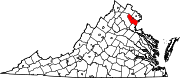
CDPs Buckhall | Bull Run | Bull Run Mountain Estates | Cherry Hill | County Center | Dale City | Gainesville | Independent Hill | Lake Ridge | Linton Hall | Loch Lomond | Marumsco | Montclair | Neabsco | Nokesville | Potomac Mills | Quantico Station‡ | Sudley | Triangle | West Gate | Woodbridge | Yorkshire
Unincorporated
communitiesAden | Agnewville | Antioch | Batestown | Bethel | Brentsville | Bristow | Buckland | Canova | Catharpin | Cornwell | Featherstone | Greenwich | Groveton | Hickory Ridge | Hoadly | Joplin | Kopp | Minnieville | Rixlew | Southbridge | Sudley Springs | Thoroughfare | Wellington
Footnotes ‡This populated place also has portions in an adjacent county or counties
Categories:- Populated places in Prince William County, Virginia
- Census-designated places in Virginia
- Northern Virginia geography stubs


Wikimedia Foundation. 2010.