- Chatham, Virginia
-
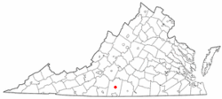
Chatham, Virginia — Town — Location of Chatham, Virginia Coordinates: 36°49′32″N 79°23′51″W / 36.82556°N 79.3975°WCoordinates: 36°49′32″N 79°23′51″W / 36.82556°N 79.3975°W Country United States State Virginia County Pittsylvania Area - Total 2.0 sq mi (5.3 km2) - Land 2.0 sq mi (5.3 km2) - Water 0.0 sq mi (0.0 km2) Elevation 748 ft (228 m) Population (2000) - Total 1,338 - Density 654.6/sq mi (252.8/km2) Time zone Eastern (EST) (UTC-5) - Summer (DST) EDT (UTC-4) ZIP code 24531 Area code(s) 434 FIPS code 51-15000[1] GNIS feature ID 1498464[2] Chatham is a town in Pittsylvania County, Virginia, United States. Chatham's population was 1,338 at the 2000 census. It is included in the Danville, Virginia Metropolitan Statistical Area. Chatham is home to Chatham High School and Hargrave Military Academy. It is also home to Chatham Hall (Official site), an all-female boarding high school. It is the county seat of Pittsylvania County[3].
It is the home to the oldest continually used building in Pittsylvania County, once an 18th century tavern, since turned into a house and now occupied by Chatham Hall faculty.
Chatham is also home to the country's top rated military preparatory boarding school, Hargrave Military Academy, which includes a special Colin Powell leadership program.[citation needed]
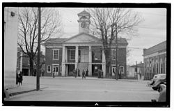
Chatham is the county seat for Pittsylvania County and has held that status since 1777.[4] There is a large U.S. Department of Agriculture office to support farmers in the area and a small branch office of the U.S. Forestry Service. The State of Virginia has built a new state prison at the site of an old work-release camp and this led to infrastructure upgrades in fire and water services to support the increased population.
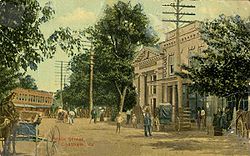
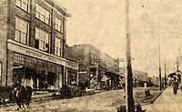
Chatham did not see any battle action during the Civil War although it is between Richmond, the capital of the Confederacy, and Danville, which contained Confederate prisons for captured Union soldiers. On Confederate Memorial Day each year, the local chapter of the Daughters of the Confederacy places flowers at the statute of a Confederate soldier which is prominent in the front of the historic Pittsylvania County Court House. There is a walking tour of this downtown historic district and a brochure for this is available at the Town Hall, or at the Historical Society building next to Town Hall. There are several bed & breakfast establishments located on Main Street in historic Greek Revival homes.
Geography
According to the United States Census Bureau, Chatham has a total area of 2.0 square miles (5.3 km²), all of it land.
Demographics
As of the census[1] of 2000, there were 1,338 people, 554 households, and 350 families residing in the town. The population density was 654.6 people per square mile (253.2/km²). There were 612 housing units at an average density of 299.4 per square mile (115.8/km²). The racial makeup of the town was 71.52% White, 26.08% African American, 0.60% Native American, 0.52% from other races, and 1.27% from two or more races. Hispanic or Latino of any race were 0.60% of the population.
There were 554 households out of which 21.7% had children under the age of 18 living with them, 49.8% were married couples living together, 10.6% had a female householder with no husband present, and 36.8% were non-families. 35.6% of all households were made up of individuals and 17.1% had someone living alone who was 65 years of age or older. The average household size was 2.22 and the average family size was 2.87.
In the town the population was spread out with 19.6% under the age of 18, 6.2% from 18 to 24, 26.8% from 25 to 44, 26.7% from 45 to 64, and 20.8% who were 65 years of age or older. The median age was 43 years. For every 100 females there were 100.0 males. For every 100 females age 18 and over, there were 100.7 males.
The median income for a household in the town was $38,938, and the median income for a family was $50,391. Males had a median income of $29,375 versus $23,472 for females. The per capita income for the town was $20,785. About 6.3% of families and 12.3% of the population were below the poverty line, including 16.4% of those under age 18 and 17.0% of those age 65 or over.
References
- ^ a b "American FactFinder". United States Census Bureau. http://factfinder.census.gov. Retrieved 2008-01-31.
- ^ "US Board on Geographic Names". United States Geological Survey. 2007-10-25. http://geonames.usgs.gov. Retrieved 2008-01-31.
- ^ "Find a County". National Association of Counties. http://www.naco.org/Counties/Pages/FindACounty.aspx. Retrieved 2011-06-07.
- ^ Crane, John (2008-06-10). "Chatham mayor blasts supervisors". Danville Register-Bee (Media General). http://www.godanriver.com/gdr/news/local/danville_news/article/chatham_mayor_blasts_supervisors/4271/. Retrieved 2008-06-11.
Municipalities and communities of Pittsylvania County, Virginia County seat: Chatham Towns CDPs Blairs | Motley | Mount Hermon
Unincorporated
communitiesAjax | Andersons Mill | Bachelors Hall | Banister | Berry Hill | Beverly Heights | Birnam Wood | Brights | Brosville | Brutus | Buford | Callahans Hills | Callands | Cartersville | Cascade | Cedar Forest | Cedar Hill | Chalk Level | Climax | Coles Hill | Dry Fork | Dundee | Ebenezer | Eldon Knolls | Fairfield Park | Farmers | Flint Hill | Fox Hollow | Galveston | Gilmer Terrace | Glenland | Glenwood | Grady | Green Acres | Green Pond | Greenfield | Grit | Halifax Hills | Henrys Mill | Hermosa | Hill Grove | Hinesville | Hollys Mill | Hollywood | Hopewell | Java | Jones Mill | Keeling | Kentuck | Lakewood | Laniers Mill | Laurel Grove | Leaksville Junction | Level Run | Lucks | Lumpkin Forest | Markham | Motleys Mill | Mt. Airy | Mount Cross | Mountain Hill | Museville | Natal | New Mount Cross | Oak Hill | Oak Hills | Oak Ridge | Oakland | Olde Hunting Hills | Peytonsburg | Pickaway | Pickerel | Pine Ridge | Pittsville | Pleasant Gap | Pleasant Grove | Pullens | Ray | Red Oak Hollow | Redeye | Renan | Riceville | Ridgecrest | Ridgeway | Ringgold | Rondo | Sandy River | Sharon | Sheva | Shockoe | Smothers | Soapstone | Sonans | Spring Garden | Stony Mill | Straightstone | Surry Hills | Sutherlin | Swansons Mill | Swansonville | Sycamore | Tightsqueeze | Toshes | Transco Village | Turkey Fork | Vadens Mill | Vance | Vandola | Weal | West Fork | Whitfield | Whitmell | Whittles | Whittletown | Witt | Woodlake Park | Woodlawn | Woodlawn Heights | Worlds | Wyndover Woods
Categories:- Populated places in Pittsylvania County, Virginia
- Towns in Virginia
- County seats in Virginia
- Danville, Virginia metropolitan area
Wikimedia Foundation. 2010.


