- Coteau du Missouri
-
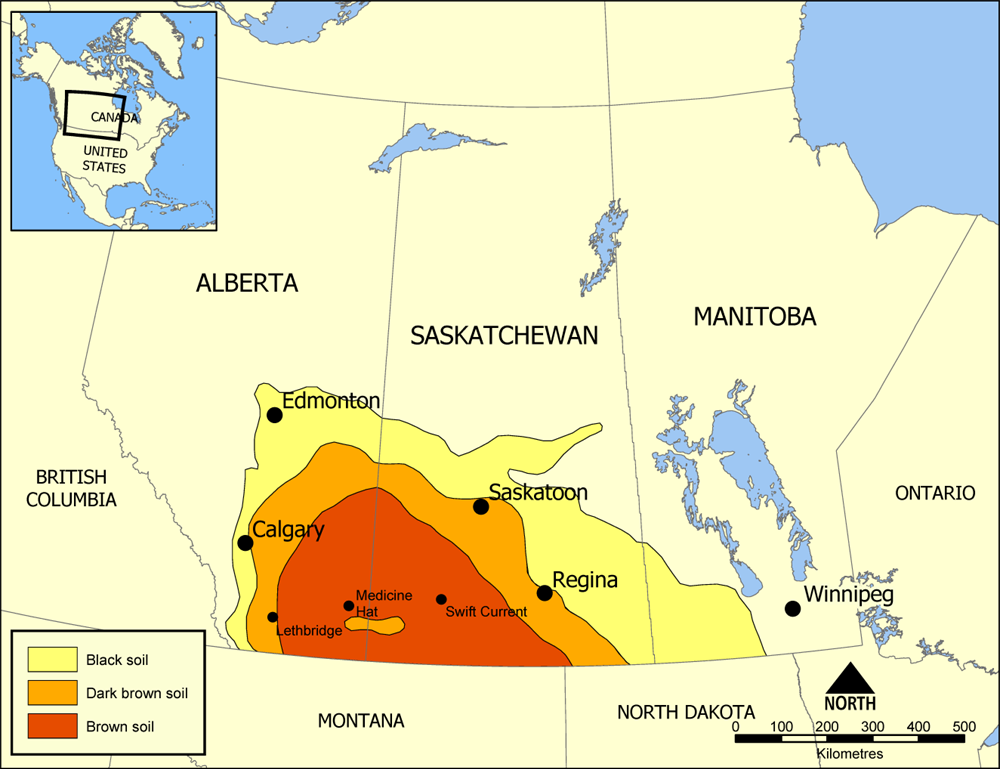
 Map of Palliser's Triangle. Canadian section of the Coteau du Missouri
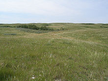
The Coteau du Missouri, or Missouri Plateau, is a large plateau that stretches along the eastern side of the valley of the Missouri River in central North Dakota and north-central South Dakota in the United States. This physiographic region of Saskatchewan and Alberta is classified as the uplands Missouri Coteau which is a part of the Great Plains Province or Alberta Plateau Region which extends across the south east corner of the province of Saskatchewan as well as the south west corner of the province of Alberta.[1] Historically, in Canada the area was known as the Palliser's Triangle regarded as an extension of the Great American Desert and unsuitable for agriculture and thus designated by Canadian geographer and explorer John Palliser. The terrain of the Missouri Coteau features low hummocky, undulating, rolling hills, potholes, and grasslands.[2]
 Missouri Plateau
Geologically the plateau is part of the extended plateau of the Great Plains in the Dakotas, and is separated from the main plateau to the west by the Missouri River Trench. The plateau is underlain by Pierre shale covered with hardened deposits from repeated glaciations. The plateau also contains deposits of lignite, mirabilite (sodium sulfate), and bentonite. While subjected to continental glaciation, it was north and west of the Driftless Area, an area which escaped glaciation.
The plateau is poorly drained and is interspersed with glacial kettle lakes. It is transversed by several broad sags marking the ancient stream valleys of the eastern continuations of the Grand, Moreau, Cheyenne, Cheyenne River, Bad, and White rivers.
To the east of the plateau, the lowland valley of the James River was formed by the lobe of the most recent ice age, separating the plateau from the Coteau des Prairies to the east.
Agriculturally the plateau is a grain and livestock region.
See also
- Coteau des Prairies
- Geography of Saskatchewan
- Cypress Hills Interprovincial Park
- Cypress Hills (Canada)
- List of highest points of Canadian provinces and territories
References
- ^ Penner, Lynden, The Encyclopedia of Saskatchewan, http://esask.uregina.ca/entry/missouri_coteau.html, retrieved 2007-05-16
- ^ Richards, J.H.; Fung, K.I. (1969), Atlas of Saskatchewan, Saskatoon: Modern Press
External links
 State of South Dakota
Pierre (capital) Topics Delegations · Famous South Dakotans · Geography · Government · History · Transportation · Symbols · Universities · Visitor Attractions
Society Culture · Crime · Demographics · Economy · Education · Politics
Regions Badlands · Black Hills · Coteau des Prairies · Coteau du Missouri · Dissected Till Plains · East River · Pine Ridge · Siouxland · West River
Larger cities
pop. over 5,000Aberdeen · Belle Fourche · Box Elder · Brandon · Brookings · Huron · Madison · Mitchell · Pierre · Rapid City · Sioux Falls · Spearfish · Sturgis · Vermillion · Watertown · Yankton
Smaller cities
pop. over 1,000Baltic · Beresford · Britton · Canton · Chamberlain · Clark · Clear Lake · Crooks · Custer · De Smet · Deadwood · Dell Rapids · Eagle Butte · Elk Point · Flandreau · Fort Pierre · Freeman · Garretson · Gettysburg · Gregory · Groton · Harrisburg · Hartford · Hot Springs · Lead · Lemmon · Lennox · Martin · Milbank · Miller · Mission · Mobridge · North Sioux City · Parker · Parkston · Platte · Redfield · Salem · Sisseton · Springfield · Summerset · Tea · Tyndall · Volga · Wagner · Webster · Winner ·
Largest CDPs
pop. over 1,000Counties Aurora · Beadle · Bennett · Bon Homme · Brookings · Brown · Brule · Buffalo · Butte · Campbell · Charles Mix · Clark · Clay · Codington · Corson · Custer · Davison · Day · Deuel · Dewey · Douglas · Edmunds · Fall River · Faulk · Grant · Gregory · Haakon · Hamlin · Hand · Hanson · Harding · Hughes · Hutchinson · Hyde · Jackson · Jerauld · Jones · Kingsbury · Lake · Lawrence · Lincoln · Lyman · Marshall · McCook · McPherson · Meade · Mellette · Miner · Minnehaha · Moody · Pennington · Perkins · Potter · Roberts · Sanborn · Shannon · Spink · Stanley · Sully · Todd · Tripp · Turner · Union · Walworth · Yankton · Ziebach
Lists 
Geography Missouri River Valley · Great Plains · Coteau du Missouri · Rocky Mountains · Big Belt Mountains · Wind River Range · Big Horn Mountains · Great Falls of the Missouri · Missouri BreaksNative American tribes History Sieur de Bourgmont · Louisiana Purchase · Lewis and Clark Expedition · Manuel Lisa · Missouri Fur Company · Independence, Missouri · Oregon Trail · Great Platte River Road · Bozeman Trail · Red Cloud's War · Treaty of Fort Laramie · Great Sioux War of 1876Engineering Pick-Sloan Plan · Flood Control Act of 1944 · U.S. Army Corps of Engineers · Montana Power Company · U.S. Bureau of ReclamationParks and preserves Categories:- Great Plains
- Plateaus of the United States
- Regions of North Dakota
- Landforms of South Dakota
- Landforms of North Dakota
- Landforms of Saskatchewan
- Landforms of Alberta
- Plateaus of Canada

Wikimedia Foundation. 2010.