- Upper Missouri River Breaks National Monument
-
This article is about the location. For the film, see The Missouri Breaks.
Upper Missouri River National Monument IUCN Category III (Natural Monument)

Location Chouteau, Fergus, Blaine, and Phillips counties, Montana, USA Nearest city Great Falls, MT Coordinates 47°47′0″N 109°1′17″W / 47.783333°N 109.02139°WCoordinates: 47°47′0″N 109°1′17″W / 47.783333°N 109.02139°W Area 377,000 acres
(1,530 km2)Established January 17, 2001 Visitors 63,512 (in 2002) Governing body U.S. Bureau of Land Management The Missouri Breaks is located in central Montana, U.S. and is managed by the U.S. Bureau of Land Management (BLM) under the full title of Upper Missouri River Breaks National Monument. Called "The Breaks" by locals, it is a series of badland areas characterized by rock outcroppings, steep bluffs and grassy plains. Created on January 17, 2001, it encompasses 377,000 acres (1,530 km2), most of which were already managed by the U.S. Government. The adjacent Missouri River was designated a Wild and Scenic River in 1976 and forms a western boundary while the Charles M. Russell National Wildlife Refuge is to the east. The Breaks country was a model for many of the paintings done by painter Charles M. Russell.
Contents
History
French trappers found the area in the late 18th century peopled by Native American tribes such as the Blackfoot, Northern Cheyenne, Sioux, Assiniboine, Gros Ventre (Atsina), Crow tribe, Plains Cree and Plains Ojibwa. The Lewis and Clark Expedition passed through the breaks in 1805 and were the first to document the region through notes and drawings, and their sighting and documentation of bighorn sheep in the breaks region was the first time this species was recorded in North America by white explorers. Much of the Breaks region has remained as it was when Lewis and Clark's party first saw it. "The confluence of the Judith and Missouri Rivers was the setting for important peace councils in 1846 and 1855. In 1877, the Nez Perce crossed the Missouri and entered the Breaks country in their attempt to escape to Canada. The Cow Island Skirmish occurred in the Breaks and was the last encounter prior to the Nez Perce's surrender to the U.S. Army at the Battle of Bear Paw just north of the monument." [1]
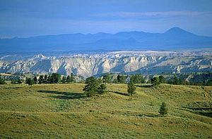 Missouri River carved the breaks into the Montana landscape
Management and conservation
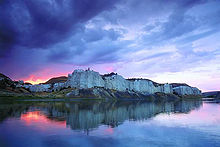 The breaks of the Upper Missouri River National Monument in Montana.
A full management plan is still under development due to various private inholdings and lease agreements between private citizens and the federal government. While conservationists would like to see some of the Breaks monument lands become designated as Wilderness, local ranchers and farmers, under long standing lease agreements with the federal government who graze upwards of 10,000 head of cattle annually within the new monument, are concerned that the monument status may adversely affect their livelihood and the economies of local towns. Under the proposed management plan from the Department of the Interior, although the resources of the monument will be given better protection, "currently permitted livestock grazing, hunting, fishing, and similar activities will generally not be affected, nor will private property (approximately 81,911 acres [331 km2]) and state land (approximately 38,722 acres [157 km2]) within the boundary of the proposed monument, as well as other valid existing rights." [2]
The Breaks is home to at least 60 mammal species and hundreds of bird species. Willows and shrubs are found along the Missouri River banks while sagebrush and short grass prairie are dominant elsewhere.
See also
External links
- "Welcome to the Upper Missouri River Breaks National Monument". U.S. Bureau of Land Management. http://www.blm.gov/mt/st/en/fo/lewistown_field_office/umrbnm.html. Retrieved 2006-08-13.
- "Upper Missouri Breaks National Monument". The Wilderness Society. Archived from the original on 2006-07-10. http://web.archive.org/web/20060710211831/http://www.wilderness.org/WhereWeWork/Montana/breaks.cfm. Retrieved 2006-08-13.
- "Upper Missouri River Breaks National Monument". Montana Wildlife Federation. http://www.montanawildlife.com/projectsissues/uppermissouri.htm. Retrieved 2011-08-11.
- Map Bureau of Land Management
Federal National Parks:National Monuments:National Battlefield:Lewis and Clark National Historic Trail • Nez Perce National Historic Trail • Continental Divide National Scenic Trail Pacific Northwest National Scenic TrailNational Recreation Area:Benton Lake • Black Coulee • Bowdoin • Charles M. Russell • Creedman Coulee • Hailstone • Halfbreed Lake • Hewitt Lake • Lake Mason • Lake Thibadeau • Lamesteer • Lee Metcalf • Lost Trail • Medicine Lake • National Bison Range • Ninepipe • Pablo • Red Rock Lakes • Swan River • UL Bend • War HorseNational Wild & Scenic Rivers:State Ackley Lake • Anaconda Smoke Stack • Bannack • Beaverhead Rock • Beavertail Hill • Big Arm • Black Sandy • Brush Lake • Camp Baker • Chief Plenty Coups • Clark's Lookout • Cooney • Council Grove • Eden Bridge • Elkhorn • Finley • First Peoples Buffalo Jump • Fort Owen • Frenchtown Pond • Giant Springs • Granite Ghost Town • Greycliff Prairie Dog Town • Hell Creek • Lake Elmo • Lake Mary Ronan • Lewis and Clark • Logan • Lone Pine • Lost Creek • Madison Buffalo Jump • Makoshika • Medicine Rocks • Missouri Headwaters • Painted Rocks • Parker Homestead • Pictograph Cave • Pirogue Island • Placid Lake • Rosebud Battlefield • Salmon Lake • Sluice Boxes • Smith River • Spring Meadow Lake • Thompson Falls • Tongue River Reservoir • Tower Rock • Travelers' Rest • Wayfarers • West Shore • Whitefish Lake • Wild Horse Island • Yellow BayState Forests:Coal Creek • Stillwater • Swan River
Wildlife Management Areas:Amelia Island • Aunt Molly • Badlands • Beartooth • Beckman • Big Lake • Blackfoot-Clearwater • Blackleaf • Blue Eyed Nellie • Bowdoin • Buffalo Head Park • Bull River • Calf Creek • Canyon Creek • Canyon Ferry • Dodson Creek • Dodson Dam • Dome Mountain • Ear Mountain • Elk Island • F Island • Flathead Lake • Flathead River • Fleecer Mountain • Fox Lake • Freezout Lake • Fresno Reservoir • Fresno Tailwater • Gallatin • Garrity Mountain • Grant Marsh • Gravelly-Blacktail • Haymaker • Hinsdale • Horseshoe Lake • Howard Valley • Isaac Homestead • Judith River • Kootenai/Falls • Kootenai/West • Kootenai/Woods Ranch • Lake Helena • Lost Creek • Lower Stillwater Lake • Madison-Bear Creek • Madison-Wall Creek • Milk River • Mount Haggin • Mount Jumbo • Mount Silcox • Nevada Lake • Ninepipe • North Swan Valley CE • Pablo • Ray Kuhns • Robb-Ledford • Rookery • Roundhom • Sanders • Seven Sisters • Silver Gate • Silver Run • Smith River • Sun River • Swan Lake • Thompson-Fisher CE • Three Mile • Threemile • Vandalia • War Dance Island • Warm SpringsHeritage registers:
World Heritage Sites • Biosphere Reserves • National Register of Historic Places • National Historic Landmarks • National Natural LandmarksLists 
Geography Missouri River Valley · Great Plains · Coteau du Missouri · Rocky Mountains · Big Belt Mountains · Wind River Range · Big Horn Mountains · Great Falls of the Missouri · Missouri BreaksNative American tribes History Sieur de Bourgmont · Louisiana Purchase · Lewis and Clark Expedition · Manuel Lisa · Missouri Fur Company · Independence, Missouri · Oregon Trail · Great Platte River Road · Bozeman Trail · Red Cloud's War · Treaty of Fort Laramie · Great Sioux War of 1876Engineering Pick-Sloan Plan · Flood Control Act of 1944 · U.S. Army Corps of Engineers · Montana Power Company · U.S. Bureau of ReclamationParks and preserves Charles M. Russell National Wildlife Refuge · Upper Missouri River Breaks National Monument · Missouri National Recreational RiverCategories:- IUCN Category III
- Federal lands in Montana
- Missouri River
- National Monuments in Montana
- Protected areas established in 2001
- Bureau of Land Management areas in Montana
- Protected areas of Chouteau County, Montana
- Protected areas of Fergus County, Montana
- Protected areas of Blaine County, Montana
- Protected areas of Phillips County, Montana


Wikimedia Foundation. 2010.