- Missouri Headwaters State Park
-
Three Forks of the Missouri
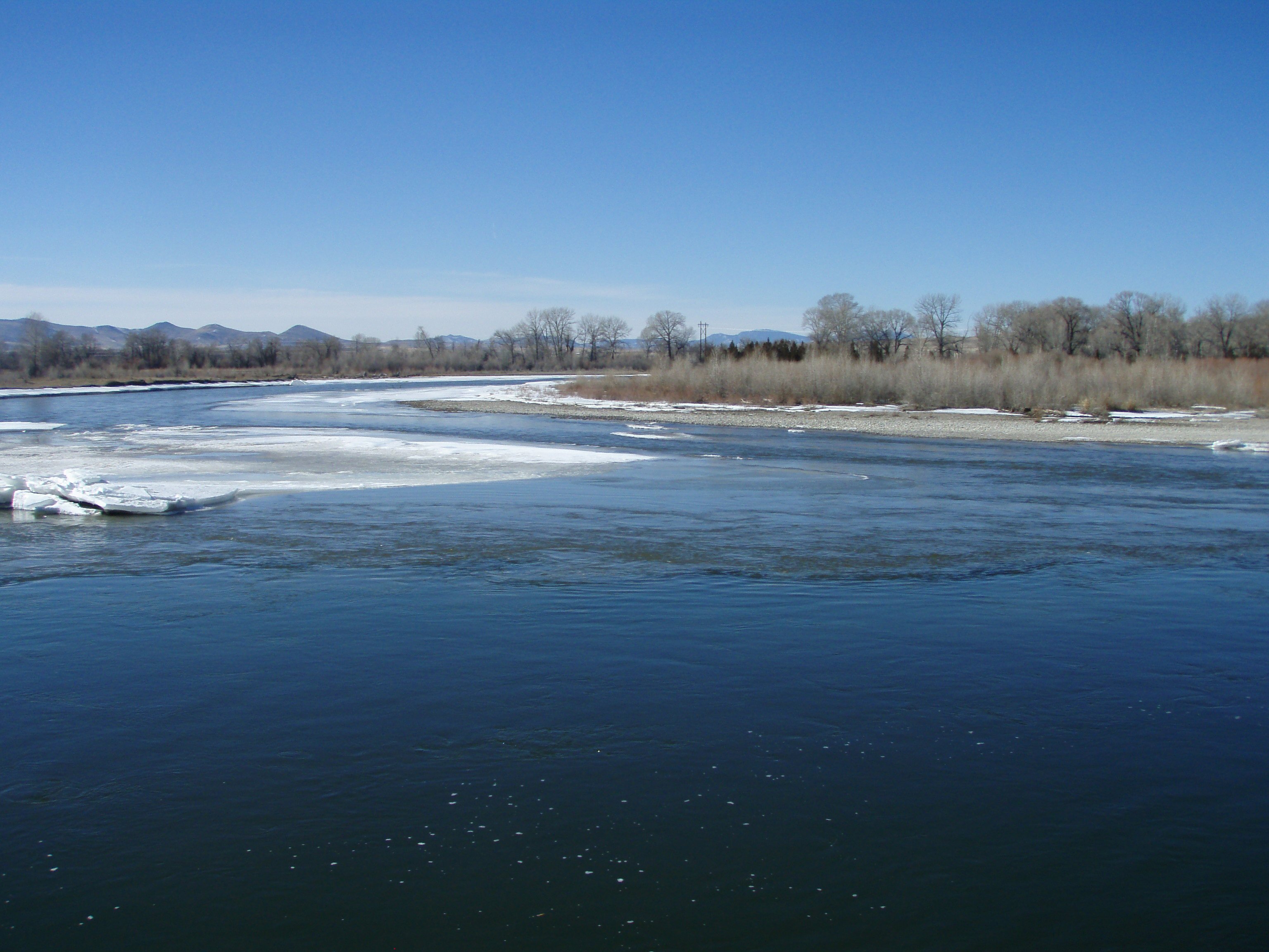
 Confluence of Madison and Jefferson

Location: Gallatin County, Montana Nearest city: Three Forks, Montana Coordinates: 45°55′15″N 111°29′53″W / 45.9207°N 111.4980°WCoordinates: 45°55′15″N 111°29′53″W / 45.9207°N 111.4980°W Built: 1805 Architect: Unknown Architectural style: No Style Listed Governing body: State NRHP Reference#: 66000433[1] Significant dates Added to NRHP: October 15, 1966 Designated NHL: October 9, 1960[2] Missouri Headwaters State Park is a Montana state park that marks the official start of the Missouri River. It includes the Three Forks of the Missouri National Historic Landmark.
It is located near Three Forks, Montana at an elevation of 4,045 feet (1,233 m).
The Missouri starts at the confluence of the Jefferson River and Madison River. It is joined about 0.6 mile down stream (northeast) by the Gallatin River.
Lewis and Clark visited the site on July 28, 1805. Meriwether Lewis in his journal entry wrote:
- Both Capt. C. and myself corresponded in opinon with rispect(sic) to the impropriety of calling either of these [three] streams the Missouri and accordingly agreed to name them after the President of the United States and the Secretaries of the Treasury and state.
The Lewis and Clark decision not to call the Jefferson the Missouri has spurred debate over what is the longest river in North America since the Missouri and Mississippi are nearly identical in length. The Missouri traditionally had been called the longest river in North America. However, 72 miles of it have been trimmed off in re-channeling its streambed — mainly for the many hydroelectric power plants in the region — so that it is now sometimes referred as second to the Mississippi in terms of length. If the Jefferson were included in the Missouri length, it would technically still be considered the longest river by the USGS experts.
The utmost headwaters of the Missouri are subject to debate but both locations ultimately drain into the Jefferson. Lewis on August 12, 1805 said he visited the headwaters on Trail Creek just above Lemhi Pass on the Continental Divide in the Beaverhead Mountains at around 8,600 feet which he described:
- the most distant fountain of the waters of the mighty Missouri in surch(sic) of which we have spent so many toilsome days and wristless(sic) nights.
However in 1888 Jacob V. Brower, who had championed turning the headwaters of the Mississippi River into a Minnesota state park, visited another site which today is believed to be the furthest point on the Missouri—now called Brower's Spring. Brower published his finding in 1896 in "The Missouri: It's Utmost Source."
The site of Brower's Spring at around 8,800 feet in the Centennial Mountains. The site now commemorated by a rock pile at the source of Hellroaring Creek which flows into Red Rock River and then into Clark Canyon Reservoir where it joins the Beaverhead then the Big Hole River before ultimately hooking up with the Jefferson.[3]
References
- ^ "National Register Information System". National Register of Historic Places. National Park Service. 2007-01-23. http://nrhp.focus.nps.gov/natreg/docs/All_Data.html.
- ^ "Three Forks of the Missouri". National Historic Landmark summary listing. National Park Service. http://tps.cr.nps.gov/nhl/detail.cfm?ResourceId=302&ResourceType=Site. Retrieved 2007-06-28.
- ^ The True Utmost Reaches of the Missouri - Montana Outdoors - July-August 2005
External links
U.S. National Register of Historic Places Topics Lists by states Alabama • Alaska • Arizona • Arkansas • California • Colorado • Connecticut • Delaware • Florida • Georgia • Hawaii • Idaho • Illinois • Indiana • Iowa • Kansas • Kentucky • Louisiana • Maine • Maryland • Massachusetts • Michigan • Minnesota • Mississippi • Missouri • Montana • Nebraska • Nevada • New Hampshire • New Jersey • New Mexico • New York • North Carolina • North Dakota • Ohio • Oklahoma • Oregon • Pennsylvania • Rhode Island • South Carolina • South Dakota • Tennessee • Texas • Utah • Vermont • Virginia • Washington • West Virginia • Wisconsin • WyomingLists by territories Lists by associated states Other  Category:National Register of Historic Places •
  Portal:National Register of Historic Places
Federal National Parks:National Monuments:National Battlefield:Lewis and Clark National Historic Trail • Nez Perce National Historic Trail • Continental Divide National Scenic Trail Pacific Northwest National Scenic TrailNational Recreation Area:Benton Lake • Black Coulee • Bowdoin • Charles M. Russell • Creedman Coulee • Hailstone • Halfbreed Lake • Hewitt Lake • Lake Mason • Lake Thibadeau • Lamesteer • Lee Metcalf • Lost Trail • Medicine Lake • National Bison Range • Ninepipe • Pablo • Red Rock Lakes • Swan River • UL Bend • War HorseNational Wild & Scenic Rivers:State Ackley Lake • Anaconda Smoke Stack • Bannack • Beaverhead Rock • Beavertail Hill • Big Arm • Black Sandy • Brush Lake • Camp Baker • Chief Plenty Coups • Clark's Lookout • Cooney • Council Grove • Eden Bridge • Elkhorn • Finley • First Peoples Buffalo Jump • Fort Owen • Frenchtown Pond • Giant Springs • Granite Ghost Town • Greycliff Prairie Dog Town • Hell Creek • Lake Elmo • Lake Mary Ronan • Lewis and Clark • Logan • Lone Pine • Lost Creek • Madison Buffalo Jump • Makoshika • Medicine Rocks • Missouri Headwaters • Painted Rocks • Parker Homestead • Pictograph Cave • Pirogue Island • Placid Lake • Rosebud Battlefield • Salmon Lake • Sluice Boxes • Smith River • Spring Meadow Lake • Thompson Falls • Tongue River Reservoir • Tower Rock • Travelers' Rest • Wayfarers • West Shore • Whitefish Lake • Wild Horse Island • Yellow BayState Forests:Coal Creek • Stillwater • Swan River
Wildlife Management Areas:Amelia Island • Aunt Molly • Badlands • Beartooth • Beckman • Big Lake • Blackfoot-Clearwater • Blackleaf • Blue Eyed Nellie • Bowdoin • Buffalo Head Park • Bull River • Calf Creek • Canyon Creek • Canyon Ferry • Dodson Creek • Dodson Dam • Dome Mountain • Ear Mountain • Elk Island • F Island • Flathead Lake • Flathead River • Fleecer Mountain • Fox Lake • Freezout Lake • Fresno Reservoir • Fresno Tailwater • Gallatin • Garrity Mountain • Grant Marsh • Gravelly-Blacktail • Haymaker • Hinsdale • Horseshoe Lake • Howard Valley • Isaac Homestead • Judith River • Kootenai/Falls • Kootenai/West • Kootenai/Woods Ranch • Lake Helena • Lost Creek • Lower Stillwater Lake • Madison-Bear Creek • Madison-Wall Creek • Milk River • Mount Haggin • Mount Jumbo • Mount Silcox • Nevada Lake • Ninepipe • North Swan Valley CE • Pablo • Ray Kuhns • Robb-Ledford • Rookery • Roundhom • Sanders • Seven Sisters • Silver Gate • Silver Run • Smith River • Sun River • Swan Lake • Thompson-Fisher CE • Three Mile • Threemile • Vandalia • War Dance Island • Warm SpringsHeritage registers:
World Heritage Sites • Biosphere Reserves • National Register of Historic Places • National Historic Landmarks • National Natural LandmarksCategories:- Protected areas of Gallatin County, Montana
- National Historic Landmarks in Montana
- Missouri River
- Montana state parks
- Lewis and Clark Expedition

Wikimedia Foundation. 2010.