- Charles M. Russell National Wildlife Refuge
-
Charles M. Russell National Wildlife Refuge IUCN Category IV (Habitat/Species Management Area)

Location Montana, USA Nearest city Billings, MT Coordinates 47°41′0″N 107°11′0″W / 47.683333°N 107.183333°WCoordinates: 47°41′0″N 107°11′0″W / 47.683333°N 107.183333°W Area 1,100,000 acres (4,450 km²) Established 1936 Governing body U.S. Fish and Wildlife Service  Map of Charles M. Russell National Wildlife Refuge
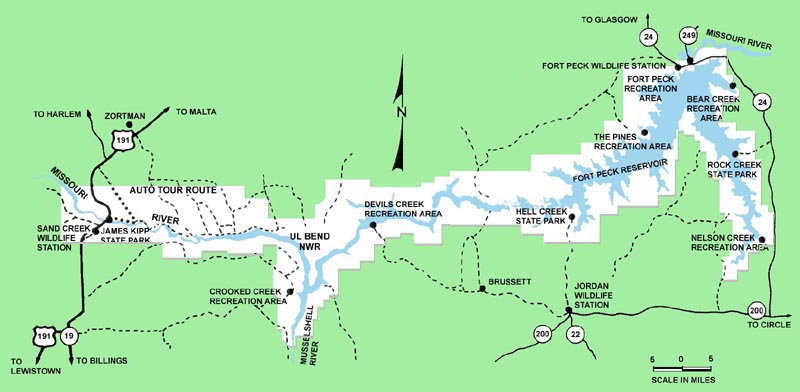
Charles M. Russell National Wildlife Refuge surrounds Fort Peck Reservoir and at 1,100,000 acres (4,450 km²) is the largest refuge in Montana, United States. Created in 1936, the refuge was named after famed painter of the American West, Charles M. Russell. Extending for a distance of 125 miles (200 km) along the shores of Fort Peck Reservoir and the Missouri River, the refuge is home to a wide variety of flora and fauna. The refuge is administered from offices in Lewistown, Montana.
245,000 acres (991 km²) of the refuge are part of the reservoir formed by the Missouri River impounded behind Fort Peck Dam which was built to provide irrigation, flood control and improve plant and animal species protection. The shores of the reservoir are host to grassy prairies, badlands and forest zones which provide an excellent blend for biodiversity. Consequently, the largest population of bighorn sheep outside the Rocky Mountains exist in the refuge. Elk, pronghorn, prairie dog, mule deer, coyote, porcupine and approximately 235 species of birds are also found here.
The UL Bend Wilderness is located in the western sections within the refuge while the Upper Missouri River Breaks National Monument is located along the western boundary of the refuge. The refuge land is spread into portions of six counties along the river; from west to east they are Fergus, Phillips, Petroleum, Garfield, Valley, and McCone counties.
U.S. Highway 191 provides access to the western sections of the refuge, but Montana Highway 24 passes along the eastern boundary, allowing better access to wildlife stations.
External links
- "Charles M. Russell National Wildlife Refuge". U.S. Fish and Wildlife Service. http://cmr.fws.gov/. Retrieved 2006-08-16.
- "Charles M. Russell National Wildlife Refuge Profile". U.S. Fish and Wildlife Service. http://www.fws.gov/refuges/profiles/index.cfm?id=61520. Retrieved 2011-08-10.
Federal National Parks:National Monuments:National Battlefield:Lewis and Clark National Historic Trail • Nez Perce National Historic Trail • Continental Divide National Scenic Trail Pacific Northwest National Scenic TrailNational Recreation Area:Benton Lake • Black Coulee • Bowdoin • Charles M. Russell • Creedman Coulee • Hailstone • Halfbreed Lake • Hewitt Lake • Lake Mason • Lake Thibadeau • Lamesteer • Lee Metcalf • Lost Trail • Medicine Lake • National Bison Range • Ninepipe • Pablo • Red Rock Lakes • Swan River • UL Bend • War HorseNational Wild & Scenic Rivers:State Ackley Lake • Anaconda Smoke Stack • Bannack • Beaverhead Rock • Beavertail Hill • Big Arm • Black Sandy • Brush Lake • Camp Baker • Chief Plenty Coups • Clark's Lookout • Cooney • Council Grove • Eden Bridge • Elkhorn • Finley • First Peoples Buffalo Jump • Fort Owen • Frenchtown Pond • Giant Springs • Granite Ghost Town • Greycliff Prairie Dog Town • Hell Creek • Lake Elmo • Lake Mary Ronan • Lewis and Clark • Logan • Lone Pine • Lost Creek • Madison Buffalo Jump • Makoshika • Medicine Rocks • Missouri Headwaters • Painted Rocks • Parker Homestead • Pictograph Cave • Pirogue Island • Placid Lake • Rosebud Battlefield • Salmon Lake • Sluice Boxes • Smith River • Spring Meadow Lake • Thompson Falls • Tongue River Reservoir • Tower Rock • Travelers' Rest • Wayfarers • West Shore • Whitefish Lake • Wild Horse Island • Yellow BayState Forests:Coal Creek • Stillwater • Swan River
Wildlife Management Areas:Amelia Island • Aunt Molly • Badlands • Beartooth • Beckman • Big Lake • Blackfoot-Clearwater • Blackleaf • Blue Eyed Nellie • Bowdoin • Buffalo Head Park • Bull River • Calf Creek • Canyon Creek • Canyon Ferry • Dodson Creek • Dodson Dam • Dome Mountain • Ear Mountain • Elk Island • F Island • Flathead Lake • Flathead River • Fleecer Mountain • Fox Lake • Freezout Lake • Fresno Reservoir • Fresno Tailwater • Gallatin • Garrity Mountain • Grant Marsh • Gravelly-Blacktail • Haymaker • Hinsdale • Horseshoe Lake • Howard Valley • Isaac Homestead • Judith River • Kootenai/Falls • Kootenai/West • Kootenai/Woods Ranch • Lake Helena • Lost Creek • Lower Stillwater Lake • Madison-Bear Creek • Madison-Wall Creek • Milk River • Mount Haggin • Mount Jumbo • Mount Silcox • Nevada Lake • Ninepipe • North Swan Valley CE • Pablo • Ray Kuhns • Robb-Ledford • Rookery • Roundhom • Sanders • Seven Sisters • Silver Gate • Silver Run • Smith River • Sun River • Swan Lake • Thompson-Fisher CE • Three Mile • Threemile • Vandalia • War Dance Island • Warm SpringsHeritage registers:
World Heritage Sites • Biosphere Reserves • National Register of Historic Places • National Historic Landmarks • National Natural LandmarksLists 
Geography Native American tribes History Sieur de Bourgmont · Louisiana Purchase · Lewis and Clark Expedition · Manuel Lisa · Missouri Fur Company · Independence, Missouri · Oregon Trail · Great Platte River Road · Bozeman Trail · Red Cloud's War · Treaty of Fort Laramie · Great Sioux War of 1876Engineering Pick-Sloan Plan · Flood Control Act of 1944 · U.S. Army Corps of Engineers · Montana Power Company · U.S. Bureau of ReclamationParks and preserves Charles M. Russell National Wildlife Refuge · Upper Missouri River Breaks National Monument · Missouri National Recreational RiverCategories:- IUCN Category IV
- Protected areas of Fergus County, Montana
- Protected areas of Garfield County, Montana
- Protected areas of McCone County, Montana
- National Wildlife Refuges in Montana
- Missouri River
- Protected areas of Petroleum County, Montana
- Protected areas of Phillips County, Montana
- Protected areas of Valley County, Montana

Wikimedia Foundation. 2010.