- Nez Perce National Historic Trail
-
Nez Perce National Historic Trail IUCN Category V (Protected Landscape/Seascape)
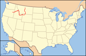
Location Oregon, Idaho, Wyoming, Montana, USA Nearest city Lewiston, ID Coordinates 46°8′31″N 116°21′34″W / 46.14194°N 116.35944°WCoordinates: 46°8′31″N 116°21′34″W / 46.14194°N 116.35944°W Established 1986 Governing body U.S. Forest Service The Nez Perce National Historical Trail follows the same journey undertaken by a band of the Nez Perce Indian tribe in 1877 during their attempt to flee the U.S. Cavalry. The 1,170 mile (1,883 km) trail was created in 1986 as part of the National Trails System Act and is managed by the U.S. Forest Service. The trail traverses through portions of the U.S. states of Oregon, Idaho, Wyoming and Montana and connects 38 separate sites across these four states that commemorate significant events which occurred to the Nez Perce during their attempt to escape capture by the U.S. Cavalry who were under orders to move the Indians onto a reservation.
Contents
History
One band of 750 Nez Perce who were not under any treaty with the U.S. Government, fought numerous engagements with the 7th Cavalry during their attempt to reach Canada and escape being forced into an Indian Reservation. Beginning near Wallowa Lake in eastern Oregon, the Nez Perce headed east into Idaho. They crossed Lolo Pass into Montana and fought a major battle at what is now known as Big Hole National Battlefield. After that, the Nez Perce continued traveling south and east, back into Idaho and then into Wyoming entering Yellowstone National Park near West Yellowstone, Montana. The tribe left the park crossing Sylvan Pass and followed the Clarks Fork River back into Montana. From there the Nez Perce headed almost straight north for Canada and almost made it. The Nez Perce were near starvation and exhaustion after fighting their last battle north of the Bear Paw Mountains, less than 40 miles (64 km) from the Canadian border, when they surrendered to U.S. authorities. Chief Joseph is widely credited with leading the Nez Perce on this journey, but he functioned more like a camp supervisor and guardian who was entrusted with handling the logistics of camp and travel and taking care of the women and children.[1]
At the time of the surrender, Chief Joseph was the most prominent surviving leader among the group and was ultimately the one who decided that they must surrender. A few members of the tribe did manage to escape to Canada, but the vast majority were relocated to Kansas and Oklahoma for eight years before being allowed to return to Idaho, near their ancestral home.
Trail description
The trail passes through numerous National Park Service managed areas, National Forests, and Bureau of Land Management Public Lands. While Oregon was already a state, the other three states the trail now passes through were still merely territories. None of the forest lands were managed by the federal government, but Yellowstone National Park was created 5 years prior to the Nez Perce journey. The trail also passes through privately owned property and it is best advised to obtain permission to enter these areas from local landowners. Little of the trail is actually a foot trail, but much of the journey can be closely followed by roads. Attempts are underway to continue to preserve right of way to allow greater access for visitors.
See also
External links
- Nez Perce National Historic Trail map
- U.S. Forest Service. "Nez Perce National Historical Trail". http://www.fs.fed.us/npnht/. Retrieved 2006-07-08.
References
Geothermal features, geography, historic structures and other attractions in the Lower and Midway Geyser Basins Lower Geyser Basin A-0 Geyser • Artesia Geyser • Azure Spring • Bead Geyser • Botryoidal Spring • Box Spring • Clepsydra Geyser • Dilemma Geyser • Fountain Geyser • Great Fountain Geyser • Jet Geyser • Labial Geyser • Narcissus Geyser • Ojo Caliente Spring • Pink Cone Geyser • Pink Geyser • Spindle Geyser • Surprise Pool • White Dome Geyser • Young Hopeful Geyser
Midway Geyser Basin Structures and History Firehole Village • Grand Loop Road Historic District • Marshall's Hotel • Nez Perce National Historic Trail • Queen's Laundry Bath HouseGeography and Geology Firehole Falls • Firehole RiverList of Yellowstone National Park related articles
 Media related to Lower Geyser Basin at Wikimedia CommonsCategories:
- IUCN Category V
- Nez Perce tribe
- National Historic Trails of the United States
- Historic districts in Montana
- Hiking trails in Oregon
- Hiking trails in Idaho
- Hiking trails in Montana
- Federal lands in Montana
Wikimedia Foundation. 2010.