- Little Bighorn Battlefield National Monument
-
Little Bighorn Battlefield National Monument 

Location Big Horn County, Montana, USA Nearest city Billings, Montana Coordinates 45°34′13″N 107°25′39″W / 45.57028°N 107.4275°WCoordinates: 45°34′13″N 107°25′39″W / 45.57028°N 107.4275°W Area 765.34 acres (3.0972 km2) Established January 29, 1879 Visitors 328,668 (in 2005) Governing body National Park Service Little Bighorn Battlefield National Monument preserves the site of the June 25, 1876, Battle of the Little Bighorn, near Crow Agency, Montana, in the United States. It also serves as a memorial to those who fought in the battle: George Armstrong Custer's 7th Cavalry and a combined Lakota-Northern Cheyenne and Arapaho force. Custer National Cemetery, on the battlefield, is part of the national monument. The site of a related military action led by Marcus Reno and Frederick Benteen is also part of the national monument, but is about three miles (5 km) southeast of the Little Bighorn battlefield.[1]
Contents
History of site
 Headquarters, from Last Stand monument
- 25 June 1876: Battle of Little Big Horn
- 29 January 1879: The Secretary of War first preserved the site as a U.S. National Cemetery, to protect graves of the 7th Cavalry troopers buried there.
- 1877: Custer, who had been buried there, was reinterred in West Point Cemetery.
- 7 December 1886: The site was proclaimed National Cemetery of Custer's Battlefield Reservation to include burials of other campaigns and wars. The name has been shortened to "Custer National Cemetery".
- 5 November 1887: Battle of Crow Agency, three miles north of Custer battlefield
- 14 April 1926: Reno-Benteen Battlefield was added
- 1 July 1940: The site was transferred from the United States Department of War to the National Park Service
- 22 March 1946: The site was redesignated "Custer Battlefield National Monument".
- 15 October 1966: The site was listed on the National Register of Historic Places.[2]
- 11 August 1983: A wildfire destroyed dense thorn scrub which over the years had seeded itself about and covered the site.[3] This allowed archaeologists access to the site.
- 1984, 1985: Archaeological digging on site.
- 10 December 1991: The site was renamed Little Bighorn Battlefield National Monument by a law signed by President George H. W. Bush.
Memorials
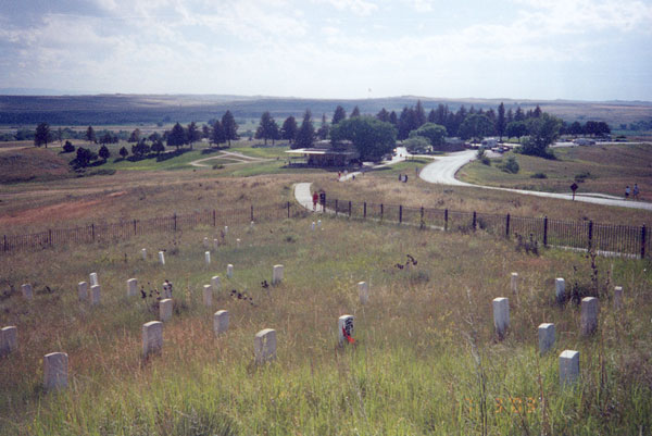
 Panoramic photo of Custer National Cemetery
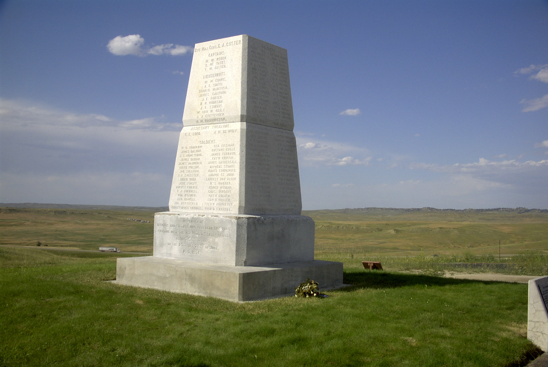
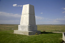 U.S. Army Memorial on Last Stand Hill
 Indian Memorial
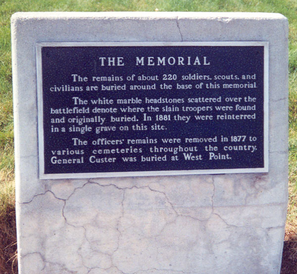
The first memorial on the site was assembled by Captain George K. Sanderson and the 11th Infantry. They buried soldiers' bodies where they were found and removed animal bones. In his official report dated April 7, 1879, Sanderson wrote:
"I accordingly built a mound out of cord wood filled in the center with all the horse bones I could find on the field. In the center of the mound I dug a grave and interred all the human bones that could be found, in all, parts of four or five different bodies. This grave was then built up with wood for four feet above ground. The mound is ten feet square and about eleven feet high; is built on the highest point immediately in rear of where Gen’l Custer’s body was found..."
 Memorial Marker
Lieutenant Charles F. Roe and the 2nd Cavalry built the granite memorial in July 1881 that stands today on the top of Last Stand Hill. They also reinterred soldiers' remains near the new memorial, but left stakes in the ground to mark where they had fallen. In 1890 these stakes were replaced with marble markers.
 Typical 7th Cavalry marker stone on the battlefield.
The bill that changed the name of the national monument also called for an "Indian Memorial" to be built near Last Stand Hill.
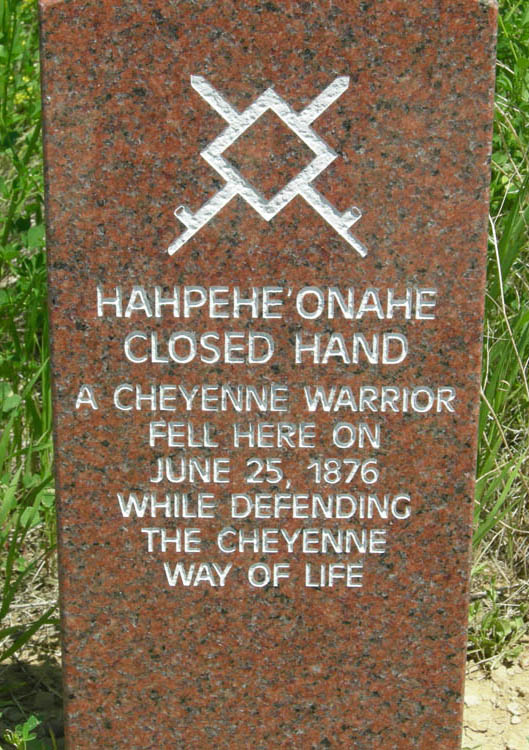
Markers honoring the Indians who fought at Little Big Horn, including Crazy Horse, have been added to those of the U.S. troops. On Memorial Day, 1999, the first of five red granite markers denoting where warriors fell during the battle were placed on the battlefield for Cheyenne warriors Lame White Man and Noisy Walking.
 Typical Indian combatant marker stone on the battlefield.
The warriors' red speckled granite memorial markers dot the ravines and hillsides just as do the white marble markers representing where soldiers fell. Since then, markers have been added for the Sans Arc Lakota warrior Long Road and the Minniconjou Lakota Dog's Back Bone.
On June 25, 2003, an unknown Lakota warrior marker was placed on Wooden Leg Hill, east of Last Stand Hill to honor a warrior who was killed during the battle as witnessed by the Northern Cheyenne warrior Wooden Leg.
See also
- List of military installations in Montana
References
- The National Parks: Index 2001-2003. Washington: U.S. Department of the Interior.
External links
 Media related to Little Bighorn Battlefield National Monument at Wikimedia Commons
- Official NPS website: Little Bighorn Battlefield National Monument
- Friends of the Little Bighorn Battlefield
- Custer National Cemetery register
- History/cultural Tours.-Custer Battlefield Tours during reenactment.
- Grave of Curly
- Grave of White Man Runs Him
- How the Battle of Little Bighorn Was Won, from the Indians' point of view
U.S. National Register of Historic Places Topics Lists by states Alabama • Alaska • Arizona • Arkansas • California • Colorado • Connecticut • Delaware • Florida • Georgia • Hawaii • Idaho • Illinois • Indiana • Iowa • Kansas • Kentucky • Louisiana • Maine • Maryland • Massachusetts • Michigan • Minnesota • Mississippi • Missouri • Montana • Nebraska • Nevada • New Hampshire • New Jersey • New Mexico • New York • North Carolina • North Dakota • Ohio • Oklahoma • Oregon • Pennsylvania • Rhode Island • South Carolina • South Dakota • Tennessee • Texas • Utah • Vermont • Virginia • Washington • West Virginia • Wisconsin • WyomingLists by territories Lists by associated states Other Federal National Parks:National Monuments:National Battlefield:Lewis and Clark National Historic Trail • Nez Perce National Historic Trail • Continental Divide National Scenic Trail Pacific Northwest National Scenic TrailNational Recreation Area:Benton Lake • Black Coulee • Bowdoin • Charles M. Russell • Creedman Coulee • Hailstone • Halfbreed Lake • Hewitt Lake • Lake Mason • Lake Thibadeau • Lamesteer • Lee Metcalf • Lost Trail • Medicine Lake • National Bison Range • Ninepipe • Pablo • Red Rock Lakes • Swan River • UL Bend • War HorseNational Wild & Scenic Rivers:State Ackley Lake • Anaconda Smoke Stack • Bannack • Beaverhead Rock • Beavertail Hill • Big Arm • Black Sandy • Brush Lake • Camp Baker • Chief Plenty Coups • Clark's Lookout • Cooney • Council Grove • Eden Bridge • Elkhorn • Finley • First Peoples Buffalo Jump • Fort Owen • Frenchtown Pond • Giant Springs • Granite Ghost Town • Greycliff Prairie Dog Town • Hell Creek • Lake Elmo • Lake Mary Ronan • Lewis and Clark • Logan • Lone Pine • Lost Creek • Madison Buffalo Jump • Makoshika • Medicine Rocks • Missouri Headwaters • Painted Rocks • Parker Homestead • Pictograph Cave • Pirogue Island • Placid Lake • Rosebud Battlefield • Salmon Lake • Sluice Boxes • Smith River • Spring Meadow Lake • Thompson Falls • Tongue River Reservoir • Tower Rock • Travelers' Rest • Wayfarers • West Shore • Whitefish Lake • Wild Horse Island • Yellow BayState Forests:Coal Creek • Stillwater • Swan River
Wildlife Management Areas:Amelia Island • Aunt Molly • Badlands • Beartooth • Beckman • Big Lake • Blackfoot-Clearwater • Blackleaf • Blue Eyed Nellie • Bowdoin • Buffalo Head Park • Bull River • Calf Creek • Canyon Creek • Canyon Ferry • Dodson Creek • Dodson Dam • Dome Mountain • Ear Mountain • Elk Island • F Island • Flathead Lake • Flathead River • Fleecer Mountain • Fox Lake • Freezout Lake • Fresno Reservoir • Fresno Tailwater • Gallatin • Garrity Mountain • Grant Marsh • Gravelly-Blacktail • Haymaker • Hinsdale • Horseshoe Lake • Howard Valley • Isaac Homestead • Judith River • Kootenai/Falls • Kootenai/West • Kootenai/Woods Ranch • Lake Helena • Lost Creek • Lower Stillwater Lake • Madison-Bear Creek • Madison-Wall Creek • Milk River • Mount Haggin • Mount Jumbo • Mount Silcox • Nevada Lake • Ninepipe • North Swan Valley CE • Pablo • Ray Kuhns • Robb-Ledford • Rookery • Roundhom • Sanders • Seven Sisters • Silver Gate • Silver Run • Smith River • Sun River • Swan Lake • Thompson-Fisher CE • Three Mile • Threemile • Vandalia • War Dance Island • Warm SpringsHeritage registers:
World Heritage Sites • Biosphere Reserves • National Register of Historic Places • National Historic Landmarks • National Natural LandmarksCategories:- IUCN Category III
- Battlefields of the wars between the United States and Native Americans
- 1879 establishments
- Protected areas of Big Horn County, Montana
- National Park Service National Monuments in Montana
- National Battlefields and Military Parks of the United States
- Great Sioux War of 1876–77
- Federal lands in Montana
- Archaeological sites in Montana


Wikimedia Foundation. 2010.