- McCone County, Montana
-
McCone County, Montana 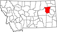
Location in the state of Montana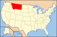
Montana's location in the U.S.Founded 1919 Seat Circle Largest city Circle Area
- Total
- Land
- Water
2,683 sq mi (6,949 km²)
2,643 sq mi (6,845 km²)
40 sq mi (104 km²), 1.50%Population
- (2010)
- Density
1,734
3/sq mi (1/km²)McCone County is a county located in the U.S. state of Montana. As of 2010, the population was 1,734. Its county seat is Circle[1].
Contents
Geography
According to the U.S. Census Bureau, the county has a total area of 2,683 square miles (6,950 km2), of which, 2,643 square miles (6,850 km2) of it is land and 40 square miles (100 km2) of it (1.50%) is water.
Major highways
 Montana Highway 13
 Montana Highway 24
 Montana Highway 200
Adjacent counties
- Valley County, Montana - north
- Roosevelt County, Montana - north
- Richland County, Montana - northeast
- Dawson County, Montana - east
- Prairie County, Montana - south
- Garfield County, Montana - west

Valley County and Roosevelt County Richland County Garfield County 
Dawson County  McCone County, Montana

Prairie County National protected area
Demographics
Historical populations Census Pop. %± 1920 4,747 — 1930 4,790 0.9% 1940 3,798 −20.7% 1950 3,258 −14.2% 1960 3,321 1.9% 1970 2,875 −13.4% 1980 2,702 −6.0% 1990 2,276 −15.8% 2000 1,977 −13.1% 2010 1,734 −12.3% As of the census[2] of 2000, there were 1,977 people, 810 households, and 596 families residing in the county. The population density was 1 people per square mile (0/km²). There were 1,087 housing units at an average density of 0 per square mile (0/km²). The racial makeup of the county was 96.97% White, 0.30% Black or African American, 1.06% Native American, 0.30% Asian, and 1.37% from two or more races. 0.96% of the population were Hispanic or Latino of any race. 37.4% were of German, 22.7% Norwegian, 8.8% American and 8.5% Irish ancestry according to Census 2000. 99.0% spoke English and 1.0% German as their first language.
There were 810 households out of which 30.20% had children under the age of 18 living with them, 66.90% were married couples living together, 3.80% had a female householder with no husband present, and 26.30% were non-families. 24.60% of all households were made up of individuals and 11.40% had someone living alone who was 65 years of age or older. The average household size was 2.44 and the average family size was 2.89.
In the county the population was spread out with 24.80% under the age of 18, 5.40% from 18 to 24, 24.30% from 25 to 44, 26.50% from 45 to 64, and 18.90% who were 65 years of age or older. The median age was 42 years. For every 100 females there were 99.70 males. For every 100 females age 18 and over, there were 103.30 males.
The median income for a household in the county was $29,718, and the median income for a family was $35,887. Males had a median income of $22,768 versus $15,368 for females. The per capita income for the county was $15,162. About 14.10% of families and 16.80% of the population were below the poverty line, including 19.40% of those under age 18 and 11.20% of those age 65 or over.
Communities
Town
Unincorporated communities
See also
- List of cemeteries in McCone County, Montana
- List of lakes in McCone County, Montana
- List of mountains in McCone County, Montana
- National Register of Historic Places listings in McCone County, Montana
References
- ^ "Find a County". National Association of Counties. http://www.naco.org/Counties/Pages/FindACounty.aspx. Retrieved 2011-06-07.
- ^ "American FactFinder". United States Census Bureau. http://factfinder.census.gov. Retrieved 2008-01-31.
External links
Municipalities and communities of McCone County, Montana Town 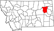
Unincorporated
communities State of Montana
Topics - Index
- History
- Governors
- People
- Geography
- State Government
- Delegations
- Visitor Attractions
Society - Crime
- Demographics
- Economy
- Education
- Politics
Regions - The Flathead
- Glacier National Park
- Regional designations of Montana
- Western Montana
- Yellowstone
Largest cities Counties - Beaverhead
- Big Horn
- Blaine
- Broadwater
- Carbon
- Carter
- Cascade
- Chouteau
- Custer
- Daniels
- Dawson
- Deer Lodge
- Fallon
- Fergus
- Flathead
- Gallatin
- Garfield
- Glacier
- Golden Valley
- Granite
- Hill
- Jefferson
- Judith Basin
- Lake
- Lewis and Clark
- Liberty
- Lincoln
- Madison
- McCone
- Meagher
- Mineral
- Missoula
- Musselshell
- Park
- Petroleum
- Phillips
- Pondera
- Powder River
- Powell
- Prairie
- Ravalli
- Richland
- Roosevelt
- Rosebud
- Sanders
- Sheridan
- Silver Bow
- Stillwater
- Sweet Grass
- Teton
- Toole
- Treasure
- Valley
- Wheatland
- Wibaux
- Yellowstone
Categories:- Montana counties
- McCone County, Montana


Wikimedia Foundation. 2010.