- Marshall County, South Dakota
-
Marshall County, South Dakota 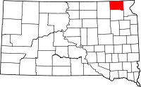
Location in the state of South Dakota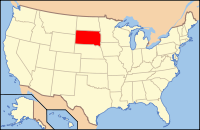
South Dakota's location in the U.S.Founded 1885[1] Named for Marshall Vincent Seat Britton Area
- Total
- Land
- Water
866 sq mi (2,294 km²)
838 sq mi (2,170 km²)
48 sq mi (124 km²), 5.41%Population
- (2010)
- Density
4,656
3/sq mi (1/km²)Time zone Central: UTC-6/-5 Marshall County is a county located in the U.S. state of South Dakota. As of the 2010 census, the population was 4,656.[2] It's county seat is Britton.[3] The county is named after Marshall Vincent, who homesteaded near Andover, South Dakota.[4]
Contents
Geography
According to the U.S. Census Bureau, the county has a total area of 886 square miles (2,290 km2), of which 838 square miles (2,170 km2) is land and 48 square miles (120 km2) is water. The total area is 5.41% water.
Townships
The county is divided into twenty-five townships: Buffalo, Dayton, Dumarce, Eden, Fort, Hamilton, Hickman, La Belle, Lake, Lowell, McKinley, Miller, Newark, Newport, Nordland, Pleasant Valley, Red Iron Lake, Sisseton, Stena, Veblen, Victor, Waverly, Weston, White, and Wismer.
Major Highways
Adjacent Counties
- Sargent County, North Dakota - north
- Roberts County, South Dakota - east
- Day County, South Dakota - south
- Brown County, South Dakota - west
Demographics
Historical populations Census Pop. %± 1890 4,544 — 1900 5,942 30.8% 1910 8,021 35.0% 1920 9,596 19.6% 1930 9,540 −0.6% 1940 8,880 −6.9% 1950 7,835 −11.8% 1960 6,663 −15.0% 1970 5,965 −10.5% 1980 5,404 −9.4% 1990 4,844 −10.4% 2000 4,576 −5.5% 2010 4,656 1.7% U.S. Decennial Census As of the census[5] of 2000, there were 4,576 people, 1,844 households, and 1,252 families residing in the county. The population density was 6 people per square mile (2/km²). There were 2,562 housing units at an average density of 3 per square mile (1/km²). The racial makeup of the county was 92.59% White, 0.09% Black or African American, 6.32% Native American, 0.09% Asian, 0.22% from other races, and 0.70% from two or more races. 0.76% of the population were Hispanic or Latino of any race.
There were 1,844 households out of which 29.80% had children under the age of 18 living with them, 57.20% were married couples living together, 6.50% had a female householder with no husband present, and 32.10% were non-families. 30.10% of all households were made up of individuals and 16.10% had someone living alone who was 65 years of age or older. The average household size was 2.43 and the average family size was 3.04.
In the county, the population was spread out with 27.00% under the age of 18, 5.10% from 18 to 24, 22.80% from 25 to 44, 23.80% from 45 to 64, and 21.30% who were 65 years of age or older. The median age was 42 years. For every 100 females there were 100.00 males. For every 100 females age 18 and over, there were 96.80 males.
The median income for a household in the county was $30,567, and the median income for a family was $36,295. Males had a median income of $27,241 versus $17,872 for females. The per capita income for the county was $15,462. About 10.40% of families and 13.90% of the population were below the poverty line, including 19.00% of those under age 18 and 14.00% of those age 65 or over.
Cities and towns
See also
References
- ^ Legislative Manual, South Dakota, 2005, p. 596
- ^ United States Census Bureau. "2010 Census Data". United States Census Bureau. http://2010.census.gov/2010census/data/. Retrieved 4 August 2011.
- ^ "Find a County". National Association of Counties. http://www.naco.org/Counties/Pages/FindACounty.aspx. Retrieved 2011-06-07.
- ^ Legislative Manual, South Dakota, 2005, p. 596
- ^ "American FactFinder". United States Census Bureau. http://factfinder.census.gov. Retrieved 2008-01-31.
Coordinates: 45°46′N 97°36′W / 45.76°N 97.60°W

Sargent County, North Dakota Brown County 
Roberts County  Marshall County, South Dakota

Day County Municipalities and communities of Marshall County, South Dakota Cities 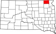
Towns Unincorporated
communityIndian reservation Footnotes ‡This populated place also has portions in an adjacent county or counties
Categories:- South Dakota counties
- Marshall County, South Dakota
- 1885 establishments


Wikimedia Foundation. 2010.