- North Fork Mountain
-
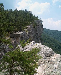
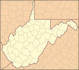
North Fork Mountain Mountain West-facing Tuscarora quartzite cliff along the crest of North Fork Mountain; pine tree in foreground.Country United States State West Virginia Counties Grant, Pendleton Range Allegheny Mountains Summit Pike Knob in Pendleton County, WV - elevation 4,291 ft (1,307.9 m) [1] - coordinates 38°40′03″N 79°26′16″W / 38.6675°N 79.43778°W Highest point Kile Knob - location Pendleton County, WV - elevation 4,588 ft (1,398.4 m) [2] - coordinates 38°36′58″N 79°28′55″W / 38.61611°N 79.48194°W Topo maps USGS Upper Tract, Moatstown, Circleville, Franklin, Hopeville Nearest town Circleville, West Virginia Website: Nature Conservancy: North Fork Mountain North Fork Mountain is a quartzite-capped mountain ridge in the Ridge and Valley physiographic province of the Allegheny Mountains (or "High Alleghenies" or "Potomac Highlands") of eastern West Virginia, USA. Kile Knob, at 4,588 feet (1,398 m), is the mountain's highest point,[2] and Panther Knob and Pike Knob are nearly as high.
North Fork Mountain is the driest high mountain in the Appalachians,[3] and has vegetation and flora different from nearby, wetter high mountain areas immediately to the west such as Spruce Knob and Dolly Sods, with pines (Pinus) abundant on the mountain's ridgecrest, in contrast with the spruces (Picea) so characteristic of these comparably high summits across the North Fork Valley.[3][4]
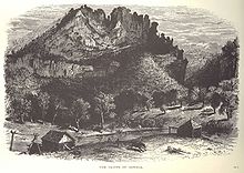
Structurally, North Fork Mountain is an anticline mountain, a major part of the Wills Mountain Anticline system. The mountain's strata (rock layers) are nearly flat, but the Tuscarora quartzite that forms the mountain's caprock is bent downwards (and now mostly eroded away) east and west of the ridge, becoming nearly vertical along the mountain's slopes, where the same quartzite stratum forms such dramatic outcrops as Seneca Rocks.
Much of the mountain is within the Monongahela National Forest, and a large portion of the mountain has been proposed for federal wilderness designation[5] or inclusion within a new unit of U.S. National Park System.[6] The Nature Conservancy's Panther Knob and Pike Knob preserves are also located on North Fork Mountain.[3]
The scenic North Fork Mountain Trail follows much of the ridge crest,[7] and only one road (U.S. Route 33) crosses the steep, rugged ridge.
Contents
Geography and geology
North Fork Mountain runs roughly northeast to southwest for 34 miles (55 km) throughout Grant and Pendleton counties in West Virginia, defining the eastern edge of the upper watershed of the North Fork of the South Branch of the Potomac River and the western edge of another portion of the watershed of the South Branch of the Potomac River. Near its northern end, it also forms the western edge of the Smoke Hole Canyon (the "Smoke Hole").
The north end of the mountain arises abruptly along the south side of North Fork Gap, a water gap along the North Fork river and West Virginia Route 28 near Cabins, west of Petersburg. The mountain continues southwest from there to Dry Run Gap in southern Pendleton County.[8]
North Fork Mountain reaches its highest elevation (4,588 feet, or 1,398 m) at Kile Knob.[2] Other notable points along the mountain include Panther Knob at 4,498 feet (1,371 m)[9] and Pike Knob, both having nature preserves owned and managed by The Nature Conservancy.
North Fork Mountain is part of the Wills Mountain Anticline,[8] a geological structure that extends from Pennsylvania through Maryland and West Virginia into Virginia. The same geologic ridge that forms North Fork Mountain is known as New Creek Mountain north of North Fork Gap. At North Fork's southern end, the ridge fragments into Devils Backbone, Brushy Mountain, and Monterey Mountain, with Snowy Mountain being a minor continuation into Virginia.
Tuscarora quartzite (or sandstone), a layer of erosion-resistant Silurian rock only about 50 feet (15 m) thick, the major ridge-forming stratum in eastern West Virginia, caps most of North Fork Mountain, often as a broad, slightly eastward-tilted slab, forming numerous west-facing cliffs and various larger outcrops such as Chimney Top and Harmon Rocks. Immediately west of the mountain, the same quartzite formation is nearly vertical, along the western limb of the anticline, forming such dramatic outcrops as Seneca Rocks, Champe Rocks, Nelson Rocks, and Judy Rocks
The lower, western slopes of the mountain and the adjacent Germany Valley are underlain by the easily eroded Ordovician-aged New Market Limestone and are penetrated by numerous caves, such as the celebrated Hellhole. Shales occur on some of North Fork Mountain's slopes.
There are no settlements on the mountain itself. Only one road, U.S. Route 33, crosses the mountain, although various smaller roads climb its slopes or reach particular points on the ridgetop.
History
Most of the forests on the North Fork Mountain were cut for timber in the late nineteenth and early twentieth centuries.[citation needed] Much of North Fork Mountain has been included in the Monongahela National Forest, established in 1911.
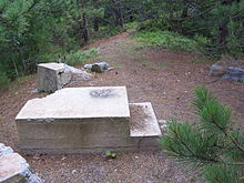
The foundations of a fire tower may still be seen on Pike Knob, with ruins of the watchman's cabin nearby.[3]
Rohrbaugh Cabin (or Allegheny Cabin), a log cabin built about 1880, still stands on the eastern slope of North Fork Mountain, along with various related structures.[10] It was listed on the National Register of Historic Places in 1993.[11]
Panther Knob, near the south end of North Fork Mountain, was first explored botanically by P.A. Rydberg of the New York Botanical Garden in 1926. He was astonished by the similarity of the mountaintop to the Pine Barrens of New Jersey, especially the presence of the beach heather (Hudsonia tomentosa).[4] However, his findings were doubted until the mountaintop was revised by a group of botanists in the 1950's.[12] Botanist Paul J. Harmon studied the flora of the entire length of North Fork Mountain's ridgetop, presenting his findings in 1981.[13]
Beginning in the early 1980's, The Nature Conservancy has become increasingly involved in habitat conservation on North Fork Mountain, working cooperatively with the U.S. Forest Service and with various private landowners, as well as establishing preserves on Panther Knob and on Pike Knob.[3]
Ecology
Vegetation
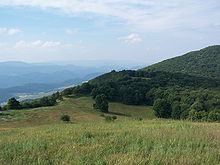
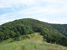
The forests on North Fork Mountain consists mainly of mixed oaks and other hardwoods, along with mountain laurel (Kalmia latifolia), flame azalea (Rhododendron calendulaceum), and wintergreen (Gaultheria procumbens). Pines (Pinus) are frequent along the ridgecrest, especially just back of clifftop openings. Fern beds and various wildflowers are common on the mountain's slopes. The mountain also supports a few high-elevation mountain meadows (sods), such as Nelson Sods near Pike Knob.[3]
The exposed sandstone cliff edges so characteristic of the west side of North Fork Mountain support narrow zones of persistingly open, treeless habitat characterized by several unusual or regionally endemic plant species, including the silvery nailwort (Paronychia argyrocoma) and the white alumroot (Heuchera alba).[4][13] Chestnut oak (Quercus montana) and Table Mountain pine (Pinus pungens) are often found just back of the cliff edges.
Pine barrens, maintained by frequent fires, cover several peaks;[13] Panther Knob supports the largest pine barren in the Central Appalachians.[citation needed] Other rocky summits, including the 4,300-foot (1,300 m) summit of Pike Knob, are blanketed by red pine (Pinus resinosa) forests,[13] here at their southernmost natural occurrences.[4][14] The Monongahela National Forest has designated 10 acres (40,000 m2) of old growth red pine forest on the mountain as the North Fork Mountain Red Pine Botanical Area.[15]
Another unusual vegetation type on North Fork Mountain is an elfin forest dominated by yellow birch (Betula alleghaniensis), mountain ash (Sorbus americana), and mountain holly.[3]
The oak-and-pine vegetation of North Fork Mountain contrasts strongly with the more diverse vegetation of the nearby mountains just west of the North Fork River, such as Spruce Mountain and the Allegheny Front, which receive considerably more rainfall.[4][3] The lower slopes of those mountains are covered by mixed Appalachian hardwood forests dominated by sugar maple (Acer saccharum), beech (Fagus grandifolia), and yellow birch (Betula alleghaniensis), with red spruce (Picea rubens) abundant at higher elevations.[4] Fraser magnolia (Magnolia fraseri) occurs on the slopes of the Allegheny Front, becoming abundant westward, but is not known from North Fork Mountain.[4]
The contrast is also great between North Fork Mountain's quartzite-outcrop vegetation and the superficially similar vegetation of the rocky sandstone-conglomerate openings of Spruce Knob, Dolly Sods, and similar sites just west of North Fork Mountain. While North Fork Mountain's lesser rainfall is a substantial factor in this difference, another consideration is the nature of the bedrock itself. North Fork Mountain's fine-grained Tuscarora quartzite erodes into sand, which either quickly disperses or persists in cracks and crevices, sometimes even forming tiny dunelets on wide, nearly flat open outcrops, as on Panther Knob. On the other hand, the various mountains along the Allegheny Front immediately west of North Fork Mountain are capped instead by the coarse Pottsville sandstone conglomerate, which erodes instead primarily into gravel rather than sand. While many widespread Appalachian rock-outcrop species are shared between the two areas, openings on Dolly Sods lack the silvery nailwort, the white alumroot, and table-mountain pine, and instead support a greater species diversity, even including such wetland plants as the small cranberry (Vaccinium oxycoccos).
Flora
Paper birch (Betula papyrifera) groves thrive along Little Creek[citation needed] and on Pike Knob;[14] this widespread northern tree is quite rare this far south. Other rare plant species on the mountain's slopes include butternut (Juglans cinerea)[citation needed] and the Smoke Hole bergamot (Monarda fistulosa var. brevis).[citation needed] Appalachian oak fern (Gymnocarpium appalachianum) and Allegheny onion (Allium alleghaniense) are also known from North Fork Mountain.[3]
Pike Knob supports not only extensive red pine (Pinus resinosa) stands but also various Appalachian-endemic species such as rusty woodsia (Woodsia ilvensis),[14] as well as boreal species such as the three-toothed cinquefoil (Potentilla tridentata)[14] and the bristly rose (Rosa acicularis),[3] here at its southernmost known stand.
The cliff-skirted 4,508-foot (1,374 m) summit of Panther Knob supports the world's largest population of variable sedge (Carex polymorpha),[citation needed] a fire-dependent globally vulnerable plant. Beach heather (Hudsonia tomentosa),[4][13] typically found on coastal dunes, and Michaux's saxifrage (Saxifraga michauxii),[4][13] a Southern Appalachian rock-outcrop endemic, also occur there.
Fauna
Wildlife on North Fork Mountain includes whitetail deer, wild turkey, black bear, and a variety of other bird, mammal, reptile, and amphibian species, including timber rattlesnakes (Crotalus horridus). Coyotes, bear, bobcats, and gray foxes are known from the area near Pike Knob.[14]
Two U.S. Fish and Wildlife Service Species of Concern are found on North Fork Mountain, the Peregrine Falcon (Falco peregrinus) and the Allegheny woodrat (Neotoma magister), and Golden Eagles (Aquila chrysaetos) are also known there. Various locally abundant but globally rare species of bats that roost in nearby limestone caverns are also often seen foraging over North Fork Mountain's western slopes. The Pink-edged Sulfur (Colias interior) is known from Panther Knob;[citation needed] the caterpillars of this widespread boreal butterfly feed on the blueberries (Vaccinium) that thrive atop this knob after fires.
Scenery and recreation
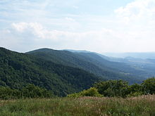
Judy Gap, through which U.S. Route 33 passes after descending the western slope of North Fork Mountain, as viewed from North Fork Mountain. One of the Fore Knobs is in the middle distance. Spruce Mountain is in the background; its highest point is Spruce Knob.
Spectacular views westward overlooking the North Fork River abound from many of North Fork Mountain's rocky outcrops. Places visible to the west from points on the ridgetop may include the River Knobs (including Seneca Rocks and Champe Rocks), the Germany Valley, the Fore Knobs, Hopeville Gorge, Spruce Mountain and Spruce Knob, and the Allegheny Front. Backpacker Magazine described these views as some of “the best mountain scenery in the East”.[citation needed]
North Fork Mountain and the River Knobs feature prominently in views from the mountaintops immediately west of the North Fork Valley, including Spruce Knob and Dolly Sods.
Nelson Sods on North Fork Mountain offers spectacular views of the Roaring Plains, Spruce Mountain, and the North Fork Valley, as well as Shenandoah Mountain to the east. Similar views are also offered by other open summits on the mountain.
State Route 28 follows the North Fork River from North Fork Gap south to Cherry Grove, offering diverse views of the River Knobs and North Fork Mountain to the east and the Fore Knobs, Allegheny Front, and Spruce Mountain to the west.
The Germany Valley Overlook on U.S. 33, on the west side of North Fork Mountain near Judy Gap, offers views of the Germany Valley and North Fork Valley, the River Knobs and the Fore Knobs, Spruce Mountain and Spruce Knob, and the Allegheny Front extending northwards toward Dolly Sods, as well as a view back to the sandstone cliffs along the crest of North Fork Mountain itself.
Panther Knob is easily viewed from the west from Snowy Mountain Road south of Cherry Grove. Other views of Seneca Rocks and North Fork Mountain are offered by U.S. 33 as it descends the Allegheny Front approaching Seneca Rocks, and by SR 28 approaching Cherry Grove from the southwest. North Fork Gap and the eastern sides of North Fork and New Creek mountains may be seen from SR 28 west of Petersburg, with the Dolly Sods portion of the Allegheny Front visible beyond the gap.
The 24-mile-long North Fork Mountain Trail (NFMT) follows much of the crest of the northern portion of the mountain.[7] This trail was called the best trail in West Virginia by Outside magazine.[16] The North Fork Mountain Trail provides access to the 4,300-foot (1,300 m) summit of Pike Knob.
Photo gallery
See also
References
- ^ "Pike Knob". Geographic Names Information System, U.S. Geological Survey. http://geonames.usgs.gov/pls/gnispublic/f?p=gnispq:3:::NO::P3_FID:1555348. Retrieved 2008-06-10.
- ^ a b c "West Virginia Summits". PeakList.org. Archived from the original on 2009-01-16. http://www.webcitation.org/5dsdeIkpq. Retrieved 2008-06-10.
- ^ a b c d e f g h i j "North Fork Mountain: Pike Knob and Panther Knob Preserves". Where we work. The Nature Conservancy. http://www.nature.org/ourinitiatives/regions/northamerica/unitedstates/westvirginia/placesweprotect/north-fork-mountain.xml. Retrieved 19 September 2011.
- ^ a b c d e f g h i Strausbaugh, P.D., and E.L. Core ([1978]). Flora of West Virginia (Second edition). Morgantown,West Virginia: Seneca Books, Inc.. pp. xl + 1079.
- ^ "North Fork Mountain Wilderness Area (Proposed)". West Virginia Wilderness Coalition. Archived from the original on 2009-07-28. http://www.webcitation.org/5ic2dASLy. Retrieved 2009-07-28.
- ^ Manchin (U.S. Senator), Joe, III (2011 (July 26)). Letter to Jerry Payne, Ripley, West Virginia. Washington, D.C.: Reprinted in the newsletter of the Friends of the Blackwater Canyon (September 2011 issue, page 10).
- ^ a b de Hart, Allen and Bruce Sundquist (2006), Monongahela National Forest Hiking Guide, 8th edition, West Virginia Highlands Conservancy, Charleston, West Virginia, pp 127-130.
- ^ a b Taylor, John Craft. "North Fork Mountain". West Virginia Encyclopedia, The. Charleston, West Virginia: West Virginia Humanities Council. ISBN 0-9778498-0-5.
- ^ "Panther Knob". Geographic Names Information System, U.S. Geological Survey. 1980-06-27. http://geonames.usgs.gov/pls/gnispublic/f?p=gnispq:3:::NO::P3_FID:1544552. Retrieved 2009-07-28.
- ^ C. Richard Bierce (January 1993). "National Register of Historic Places Inventory Nomination Form: Rohrbaugh Cabin". State of West Virginia, West Virginia Division of Culture and History, Historic Preservation. http://www.wvculture.org/shpo/nr/pdf/grant/93000490.pdf. Retrieved 2011-06-20.
- ^ "National Register Information System". National Register of Historic Places. National Park Service. 2009-03-13. http://nrhp.focus.nps.gov/natreg/docs/All_Data.html.
- ^ Core, Earl L. (1952). "Botanizing on Panther Knob, West Virginia". Wild Flower 28: 35–38.
- ^ a b c d e f Harmon, Paul J. (1981). Ridge Top Flora of North Fork Mountain, Grant and Pendleton Counties, West Virginia (MS Thesis). Carbondale: University of Illinois.
- ^ a b c d e The Nature Conservancy (Undated). Pike Knob Preserve, Central Appalachians. The Nature Conservancy. pp. 2.
- ^ Forest Service, U.S. Department of Agriculture (September 2006), Monongahela National Forest Land and Resource Management Plan; Chapter III, pp 46 and 62.
- ^ Outside, April 1996 issue.
External links
- At The Nature Conservancy Website:
- WV Wilderness Coalition Proposal
National Recreation Areas Wilderness Areas Big Draft Wilderness • Cranberry Wilderness • Dolly Sods Wilderness • Laurel Fork North Wilderness • Laurel Fork South Wilderness • Otter Creek Wilderness • Roaring Plains West Wilderness • Spice Run Wilderness
Observation Towers Lakes Lake Sherwood • Spruce Knob Lake • Summit Lake
Mountains and Summits Allegheny Front • Allegheny Mountain • Back Allegheny Mountain • Backbone Mountain • Barton Knob • Bickle Knob • Champe Rocks • Cheat Mountain • Gaudineer Knob • Mount Porte Crayon • North Fork Mountain • River Knobs • Seneca Rocks • Shavers Mountain • Spruce Knob • Spruce Mountain
Other Major Areas Blackwater Canyon • Camp Allegheny • Bear Rocks Preserve • Canaan Valley • Cheat Summit Fort • Cranberry Glades • Fernow Experimental Forest • Gaudineer Scenic Area • Germany Valley • Highland Scenic Highway • Sinks of Gandy • Smoke Hole Canyon
Rivers and Creeks US Forest ServiceCategories:- Mountains of West Virginia
- Allegheny Mountains
- Geography of Grant County, West Virginia
- Geography of Pendleton County, West Virginia
- Monongahela National Forest
- Ridges of the United States
Wikimedia Foundation. 2010.

